Wednesday, February 28, 2018

The Most Famous Andean Temple – Part II

Continuing from the previous post, “The Most Famous Andean Temple – Part I,” regarding the original pre-Inca period temple built in the Huatanay (Watanay) River Valley, that is the Cuzco Valley, located on the eastern end of the Knot of Cusco, where anciently the Killke culture first settled. At the time of the Spanish invasion, the Pre-Inca peoples and even the Inca themselves, filled the temple grounds with a fabulous wealth in life-sized statues and figurines of people, animals and plant life made of gold, silver and copper.
     Toward the west of the Illapa sanctuary on these grounds is the Temple of K'uychi (Rainbow), which size and characteristics were similar to those of the original, but it was partially mutilated on its northwest portion in order to build the Dominican Convent.
The famous stone of twelve angles, a most remarkable engineering fete in ancient Peru that attracts tourists from all over the world. It was part of the wall of the Inca Roca before the Spanish conquest
 
The Quechua name of this area is Tuq’ukachi which means “the opening of the salt.” The street of Hatun Rumiyuq, meaning “the one with the big stone,” is the most visited by tourists today. Here was the palace of Inca Roca, which was converted by the Spanish to the Archbishop’s residence. Along this street that runs from the Plaza de Armas to the Barrio de San Blas, one can see the “Stone of Twelve Angles,” which is viewed as a marvel of ancient stonework and has become emblematic of the city's history.
    In ancient Cuzco, the Rainbow was another important symbol, elevated to one of divinity during Incan Society because it was considered to have come from the sun, therefore, the Inca emperors adopted it as their emblem because they boasted of being descendants of the Sun.
    In the "Tawantinsuyo" they used an Unancha, that is, an emblem or flag having the seven colors of the rainbow; that banner was recovered and today is used as Qosqo City's flag. That temple was completely adorned with gold and over one of its walls there was a rainbow painted over the gold plates covering the whole temple. In the Peruvian Andes there are popular beliefs that are effective since immemorial times regarding the rainbow, and today there are numerous legends and myths surrounding the symbol.
    On the lateral eastern side there is a trapezoidal window coinciding exactly in size, shape, height and level with the two of the Illapa temple, creating an excellent perspective. Those three windows are leveled; for leveling Quechuas used water based devices. Water was stored in a ceramic jar with two small holes as finders in two opposing ends that constituted an incipient but useful level.
All that remains visible today is the foundation wall around the current Santo Domingo cathedral the Spanish built atop the pre-Inca masonry. The original, round stone wall is clearly seen at the base of the cathedral
 
    Between the K'uychi and Illapa temples there is an open area in which on the rear wall are three finely carved channels to which tradition and popular imagination call "phonic channels" because when being hit they emit "different musical notes". However, those channels on the original ground level served for draining rain waters concentrated in the complex's central patio, similar channels are found in all the complexes or buildings that did not have rooves.
    Obviously, inside the whole complex there were different enclosures for the "Willaq Uma" (High Priest) and the other lesser priests. During Inca times, these spaces were used for sheltering the different idols coming from the conquered, submitted or incorporated nations that were concentrated inside the Qorikancha. In this way, the Inca allowed the cult of conquered people, so that if there were rebellion attempts in the conquered nations, reprisals in Qosqo were against their gods, producing the religious intimidation that gave many benefits to the Inca.
    In the complex's southern sector there was a terracing that reached even as far as the edge of the channeled Saphi River (today the river flows beneath the Avenida el Sol). The terraces were part of the Qorikancha's Solar Garden which was probably the most extraordinary example of wealth found in this temple. It was a very special garden because it contained samples of the regional flora and fauna and even persons sculpted in natural size, made of gold and silver.
    Garcilaso and other chroniclers wrote that there were many animals, from insects to mammals; plants, from small flowers to native trees; children, men and women, and numerous other precious metal objects made by Quechua goldsmiths occupying this exceptional garden. Until some decades ago it was argued that chroniclers had written many lies and fantasies about this; however, recent archaeological diggings carried out were slowly demonstrating the truth as some golden plant and animal shaped artifacts were found. The magnificence, quality and amount of objects in this garden astounded all the conquerors that saw it. Of course, that did not keep the Spanish from ruining and looting the garden and its objects, which were melted down in order to make coins or bars to facilitate their transportation to Spain. That is one of the reasons why in the Peruvian museums there are not important Inca artifacts of precious metals.
    It is evident that the Qorikancha was the richest, most elaborate and dazzling temple of the pre-Inca period, where they concentrated and displayed the gold and silver of their territory, which arrived as offerings for the sacred city and the temple. During Inca times, gold and silver did not have economic value, only the beauty and prestige of their grandeur as did colored conch shells or "mullu" (genus Spondylus gaederopus) that came from the Ecuadorian coasts; they were highly appraised because they represented the "Qochamama" or "Mother Sea."
    Anciently, Peruvian gold was easily found in deposits near rivers, panned in stream beds, and exposed nuggets lying on the surface, as well as in ores mixed with silver and copper. By Inca times, it was extracted from diverse veins or mines, but still being panned in the Amazonian rivers where gold is found as dust or nuggets among the sand. In these later times, gold dust was concentrated or brought together with mercury and then burned at high temperatures in order to liberate the gold from mercury. The use of mercury among Quechuas was very controlled due to its harmfulness. Today, both gold and silver is still abundant in the Andean Countries, which have an important production of that metal.
    Also in this vast temple complex there were five water fountains, in which flowed clean water transported through underground channels from springs or sources kept completely secret. During Inca times, those water fountains had religious duties as water was another deity in the Andean Religion; they were also adorned with precious metals, had golden spillways, and large gold and silver jars. In colonial times the water was dried up as a consequence of lack of maintenance and deliberate Spanish destruction.
    Garcilaso indicates that he saw just one of them: the last one which Dominican monks used to irrigate their vegetable garden. Since 1975, the convent and church were reconstructed, at the same time some archaeological digs were performed uncovering one of the five original fountains, located before the "solar round building,” that tapped into the two rivers that had been channeled around the city, still flowed through its finely carved conduits. It is possible that in the future remains of the other fountains described by Garcilaso will be located.
    Until 1990 most of the Solar Garden's space was covered by different buildings; thanks to a law that was put into effect by the end of the 1980s, the central government and especially the Qosqo's Municipality bought the lands and houses of the sector and some archaeological works were carried out in an attempt to “uncover the Peruvian past” and more of the temple Cieza de Leon said, “...was one of the rich temples existing in the world."
    In the middle of the cloister's central patio is an eight-sided fountain carved in a single andesite piece that according to some historians was of Inca manufacture; however, its shape and characteristics are not classical in Incan stonemasonry. Far more likely, it was pre-Inca, as would have been the gold and silver imagery in the garden and the base of the colonial addition of St. Dominic Church.
    One of the important factors in all of this is the timing. Pedro Cieza de León was in Peru from 1536 to 1551; Gómez Suárez de Figueroa, known as Inca Garcilaso de la Vega was in Peru from 1539 to 1560; and Vicente de Valverde y Alvarez de Toledo (Vincent de Valley Viridi), a Spanish Dominican friar, who was involved in the Conquest of the Americas, was named Protector of the Natives and Inquisitor in 1536, the year that the Holy See established Cuzco as the seat of the first diocese of the Catholic Church in South America, covering the entire continent, up to modern Nicaragua. Emperor Charles V, named Valverde as the first Bishop of Cuzco, and Pope Paul III ratified this choice in a consistory held in January 1537.
    Valverde then returned to Peru in 1538, two years after Cieza first arrived in Cuzco. In 1539, and one year before Garcilaso was born in Cuzco, the first, small cathedral was begun on the grounds of the original temple and completed a year later. The main cathedral construction was not started until 1559 and took almost a century to complete, using blocks pilfered from the nearby site of Sacsayhuaman. Today it is joined by Iglesia del Triunfo, 1539 to its right and Iglesia de Jesus Maria, 1733, to the left.
    Thus, the pre-Inca temple, which the Inca occupied until their defeat by the Spanish, stood until 1559, eight years after Cieza’s death, and when Garcilaso was twenty years old, one year before he left Cuzco for Spain. This should suggest to all that both Cieza and Garcilaso’s descriptions of the temple and its grounds were both first hand views of the site and personal experiences within the temple and grounds and the palace next to it of which they both wrote.

Tuesday, February 27, 2018

The Most Famous Andean Temple – Part I

-->Qorikancha (Intikancha), the famous Sun Temple of Qosqo (Cusco) from the Amayra Qusqu Wanka, meaning “Rock of the owl,” was and is in practice a synthesis of the Incan organization, architecture and religion; that had already reached the summit of their level by 1438. It possibly represented the "Navel of the World"; therefore, the world's center in the pre-Hispanic Andean Cosmovision.
Watanay Valley, or Cuzco Valley, today with Wayna Tawqaray on th slopes of the distasnt slope; Muyu Urqu, or “circle mountain,” the hill on the right; Watanay River flows at the base of these two slopes

According to Inca history, it was the first Inka, MankoQhapaq who built the original temple in the Watanay Valley (Qosqo Valley). It is claimed that in 1438 the ninth Inka, Pachakuteq, reconstructed, enlarged, improved and modernized the most important religious complex of the vast Incan Society. There are certain discrepancies about the original name of the site that cause some confusion. Frequently in chronicles and historical treatises the name Intiwasi is listed, (inti= sun, wasi= house), which means "Sun House"; also the name Intikancha is used, which means "Sun Palace" (this is considering that almost all Inkan palaces had the noun "Kancha"). However, its most popular name is Qorikancha, which means "Golden Palace". According to Maria Rostworowski (Tovar de Diez Canseco), a Peruvian historian and Inca Empire researcher, the ancient temple was known as "Intikancha" and after Pachakuteq as "Qorikancha".
The Qorikancha, the ancient Pre-Inca Temple upon whose ruins the Santo Domingo Church and monastery was built by the Spanish conquerors

All the chroniclers appear to agree that the quality of the building was extraordinary, made with gray basaltic andesites coming from the quarries of Waqoto and Rumiqolqa. The walls have the "Sedimentary" style that is the height of architectural expression in pre-Columbian America. The stones are between medium to large which outer surface is rectangular; the structure is straight horizontal that in the most important temples exhibit side views with marked convexity. The joints between stones are polished, so perfectly made that not even a razor blade can be inserted between them.
    The cross section structure is "tied up” with "H" shaped bronze clamps or clips in the internal joints that fastened together the lithic pieces avoiding harmful horizontal displacements in case of earthquakes. The wall also have a decreasing vertical structure, that is, with bigger stones in the lower part and every time smaller toward the top. The walls are wider in the base than on the top; with the classical inclination inward balanced with the trapezoidal shape of doorways, niches and openings. Those characteristics make the walls support themselves forming a resistant, solid, anti-seismic structure that was able to resist the two huge earthquakes after the Spanish invasion, in 1650 and 1950 that destroyed every colonial building.
    Today in some of these walls there are a few cracks, that are not a result of bad calculation or technique of the Quechua architects, but simply, consequence of changes carried out in colonial times, the earthquakes and mainly exposition to inclement weather and erosion after all of them. According to some studies the finely carved stone walls had a continuation of sun-dried mud-bricks on the top forming very steep gable ends in order to enable drainage of rain waters. The roofing was thatched made in wood and "ichu" the wild Andean bunch grass, with eaves projecting out about 5 ¼  feet, and roofs often covered on festive days with showy multicolored rugs made with special feathers.
    Graziano Gasparini, the distinguished historian of architecture, conducting a series of lectures in Cuzco in 1975, claimed that the “gold edging” often mentioned by chroniclers, which served as a crown surrounding the whole outer upper side of the temple, which dissembled the difference between the fine stone wall and the upper adobe wall. The complete floor in the open areas of the temple were covered with finely paved flagstones while the floors inside the enclosures were made with kilned clay as a solid ceramic block like the treated floors found in Machupicchu.
    The temple's main gate faced toward the Northeast; almost in the same position of the present-day entrance to the Santo Domingo (St. Dominic) Convent, overlooking the Intipanpa ("Sun Plaza") that occupies the small park in front. According to chroniclers this was a religious complex constituted by temples dedicated to different deities. It had a layout very similar to that of a classical "kancha"; with enclosures around a central patio where according to Cieza de Leon, every doorway was veneered with gold plates.
Remains of the Qorikancha, now the foundation below Spanish colonial construction of the church and monastery of Santo Domingo

The Sun Temple stood out in the complex, covering the space occupied today by the Santo Domingo Church. Its eastern end was completely demolished while the western one still subsists partially forming what is known as "solar round building", that is, the original ancient Peruvian semicircular wall overlooking the present-day Arrayan street and the Avenida el Sol.
    As stated by Cusquenian Chronicler Garcilaso de la Vega who stated that "... what I swallowed in the milk and saw and heard from my ancestors..." in telling us that the Sun Temple had its four walls and even the wooden ceiling completely covered with gold plates and planks, with a rectangular floor plan and a very high thatched roof for facilitating ventilation. Also, on the eastern wall of this temple must have been the facade and Main Altar that as it is known contained the representation of the Sun God in a gold plate with the shape of a "round face and rays and flames". That solar representation was so huge that it covered all the temple front from wall to wall; in the treasures distribution among the conquerors, that golden piece corresponded by casting of lots to Mancio Sierra de Leguisamo, an incurable gambler who lost it all during one night playing dice—a game in which the famous saying "bet the sun before dawn" was created.
    Chronicler Sarmiento de Gamboa suggests that Pachakuteq ordered a layout so that the Sun would occupy the main place along with the Wiraqocha god representation on its right side and that of Chuquiylla ("Chuki Illapa" or thunder, lightning and thunderbolt) to its left side. Also, on both sides of the Sun image were the "Mallki" (mummies or embalmed bodies in a fetal position) of the dead Inka Kings, according to their antiquity, and over litters of solid gold.
    In the Andean Cosmogony it was considered that the Moon or Mamakilla was the Sun's wife. Therefore, the Moon Temple was located on the eastern side of the Solar Temple; it had a rectangular floor plan with the best quality of architecture, unfortunately it was almost completely destroyed by the Spanish in order to build the Catholic Church—one of its gates is still seen as well as its eastern wall with the classical trapezoidal niches. Among those niches is the horizontal dark stripe that is believed to be the support zone of the silver plates that completely covered its walls, and in the center of the temple was a silver Moon representation and on both sides of it the embalmed bodies of the dead Qoyas (Queens), according to their antiquity.
    In the eastern side of the Moon temple; divided by a narrow passage with an impressive double jamb doorway that has a stone with 14 carved angles on its outer face, is the Temple of Ch’aska and the Stars (Ch'aska was the Venus star). In ancient Peruvian lore, stars were particularly significant, that played a very important role in astral observation and future prediction with relationship to weather, agriculture, prosperity, welfare, etc. During Incan times, these stars became known as “moon’s maids.”
    Even today Andean peasants (descendants of Inkas) observe the brightness of stars formed in constellations in order to foresee their future. For example, almost always when some stars are very shiny it means that during the next farming season there will be droughts. Three walls of the temple are almost complete, and the fourth wall toward the West was destroyed in colonial times, but was reconstructed following its original characteristics—today, restorations are made with the original materials or stones, giving more importance to protection and solidification works in the monument.
    The considerably sized Venus Temple is surrounded by 25 trapezoidal niches that were used for holding statues, offerings and elements related to the stars. Also by the middle of the niches was the horizontal stripe that supported the silver "planks" covering the temple. In addition, the entire ceiling had star representations of different sizes "like the starry sky."
    It should be of interest to the Latter-day Saint that the symbols used in the construction of this temple had the Sun, Moon, and Stars, symbols tht have specific and clear meaning to us today.
    In addition, the temple had two very high entrance gates and in the wall, between them, are two very special trapezoidal niches having carvings of stripes and hollows around, to which Garcilaso called “tabernacles.” One of those niches overlooks inside the temple and the other outside, but they occupy the same height on both wall sides. Originally they were veneered with gold plates and planks, and "... on the molding's corners there were many encasings of precious stones such as emeralds and turquoises...".
    Inside the temple, close to a corner and over the stone wall, there was a plaster coat with murals that are a souvenir of the colonial occupation of this amazing temple. The original ancient Peruvian walls were used as foundations for the later Inca and Spanish mud-brick colonial building that is still seen over the rear stone wall.
    In front of the Stars Temple, on the other side of the present-day central patio is the Temple of “Illapa,” or "Chuki Illapa," the deity compound of “thunder, lightning and thunderbolt” that was considered as the "Sun's servant." During Inkan times, Illapa was the "Storm God," the ruler of rain, hail and snow, the hurler of thunderbolts; its shrine was adorned with gold. In addition, the temple had three trapezoidal single jamb doorways and its present-day northwestern lateral wall was partially reconstructed following its original characteristics. That enclosure is smaller than the previously described temples, with walls having the classical trapezoidal niches and two windows in its lateral walls; on the upper side of the front wall there were carved moldings which purpose is unknown.
(See the next post for more information on this original temple site)

Monday, February 26, 2018

The Meaning of Ziff – Part II

Continuing from the previous post regarding the probability that the Nephite Ziff mentioned in Mosiah is the modern semi-precious metal known today as bismuth. 
    As a relatively rare metal, sometimes classified as a metalloid, Bismuth is found in the earth's crust at about the same abundance as silver, and is usually associated with copper, lead, tin, wolfram (an important tungsten ore), silver, and gold ores.
The most common bismuth minerals are bismuthinite and bismite. Generally, these and other bismuth minerals occur in minute quantities within ores of other metals, such as gold, silver, lead, zinc, and tungsten

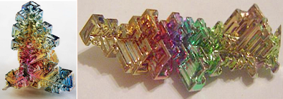
Bismuth usually forms in a non-attractive mass, though occasionally does form in aesthetic lustrous crystals, which thin layer of oxide on the otherwise pure crystal causes light of certain wavelengths to interfere constructively upon reflection giving rise to the color seen on the surface that provides an incredible iridescence. It is the variations in thickness of the oxide layer, that causes the fluctuating wavelengths of light to interfere with reflection and the resulting beautiful kaleidoscopic colors displayed through the trigonal crystal.
    Interestingly, while these decorative crystals can and do form naturally, they can also be created through heating the clean bismuth and then slow cooling it. They can also be manipulated by the cooling rate, which affects the size and structure of the resulting crystals—the slower the cooling, the larger the crystals.
    The difference in colors results from the variations in the thickness of the oxide layer on top of the crystal, thus causing direct light on the crystals to form variations of different light wavelengths that disrupt the reflection, which provides their beautiful rainbow effect.
    In their final stages, the bismuth provides beautiful decorative properties that anciently were used solely for decoration because of their shimmering iridescent colors. Anciently it was called tectum argenti, meaning “silver being made,” and was thought of as a “half-way form of silver,” that is, in the process of being formed but not yet finished. In ancient Andean Peru, where the metal is predominantly found, while the ancient name has been lost, it was used as late as the Incas for decoration, and found in burial chambers as a special bronze alloy for their knives. It was also used with bronze, and though bismuth can make bronze brittle, the ancient Peruvian smiths learned how to use it to give bronze new properties without such embrittlement (Robert C. Cowen, “Ingenious Metalsmiths,“ The Christian Science Monitor,1984).
Sican ceremonial tumi knife, distinctly characterized by a semi-circular blade, made of either bronze, copper, gold-alloy, wood, or silver alloy and is often inlayed with semi-precious stones such as lapis lazuli. Tumis are most often associated with Pre-Inca cultures in the Peruvian Coastal Region

According to Yale metallurgist Robert B. Gordon, and graduate student John W. Rutledge, the bronze of the tumi ceremonial knife found in pre-Inca Peru contained 18% bismuth and 9% tin, and was the first known use of bismuth in bronze anywhere in the world. The alloy was not embrittled by the bismuth because the bismuth-rich constituent did not penetrate the grain boundaries of the matrix phase, yet the use of bismuth facilitated the duplex casting process by which the tumi was made and formed an alloy of unusual color (Science, Vol 223, Iss 4636, Washington DC, 1984, pp585-586).
    Bismuth is one of the few materials that has a greater density as a liquid than as a solid, and when melted, can be poured into virtually any shape, from thin sheet layers to thick ingots where it solidifies once again. In ancient Egypt it was found to be mixed with copper in thin sheets to decoratively cover wood (Alfred Lucas and J.R. Harris, Ancient Egyptian Materials and Industries, Dover Publications, New York, 1929, p216). Today, in addition to Peru, major producers of Bismuth are Bolivia, Mexico, Japan and Canada.
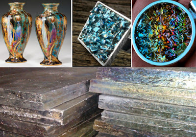
Versatile bismuth. Top Left: The lusters on the vases result from a particular metal amongst their various constituents: orange luster based on iron: yellow on uranium; mother-of-pearl despite its multi-color effect from only one metal, titanium or bismuth; Top Middle and Right: Bismuth in settings, small and large; Bottom: Pure bismuth metal ingots

Bismuth was used in early alloys, made by melting and mixing two or more metals, resulting in a mixture that has properties different from those of the individual metals. In addition, it is the most diamagnetic metal; that is, it resists being magnetized and is repelled by a magnetic field. It also has low electric conductivity and the greatest electrical resistance when placed in a magnetic field, a trait called the Hall effect. 
    It also has a very low thermal conductivity—lower than any other metal except mercury, and has a relatively low melting point, especially when alloyed with tin and lead. Bismuth burns with a blue flame and clouds of yellow oxide when heated in air (“The History and Use of Our Earth’s Chemical Elements: A Reference Guide,” Greenwood Publishing Group, 2006). 
    When liquid bismuth freezes, it expands rather than contracts because it forms a crystalline structure similar to water—only four other elements expand when they freeze: silicon, gallium, antimony and germanium.
    The name bismuth was probably taken from two German words, weisse masse, meaning "white mass," describing how the element appears in nature. Later the name was shortened to wismuth, and then to bisemutum, before bismuth came into common use. It is a soft, silvery metal with a bright, shiny surface and a yellowish or pinkish tinge, and the metal breaks easily so it cannot be fabricated (worked with) at room temperature. Its melting point is 520°F., though some bismuth alloys melt at 158ºF., and its boiling point is 2,847°F (58 of the 94 elements that have boiling points, have boiling points higher, such as lead with a boiling point of 3164ºF. (melting point 621º), with silver, tin, aluminum, copper, nickel, iron, gold, etc., even higher (though tin has a lower melting point)—carbon, needed to mix with iron to make steel, has a boiling point of 8720ºF).
    All of this suggests that bismuth is easy to work with as an alloy, and can be melted and poured into molds that have any shape or size, and as it cools, unlike most metals, it expands (instead of contract) as it solidifies (changes from a liquid to a solid), and in so doing it fills all the corners of the mold. Though it is relatively rare in the Earth (0.2 parts per million, about twice as abundant as gold), it is plentiful in China, Mexico and Peru (world mining production in 2010 was 8,900 tonnes, with the major contributions from China: 6,500 tonnes; Peru: 1,100 tonnes; and Mexico: 850 tonnes), and typically found with lead, silver and gold.
    However, the major ores of bismuth: bismuthinite (the sulfide), also called bismuth glance, and bismite (the oxide) are found extensively in South America, and are rare in the U.S. and Mexico. In fact, Peru is one of the world’s top mineral producing countries, extracting from the rich mountains gold, silver, copper, zinc, lead, tin, arsenic trioxide and minerals like bismuth and molybdenum.
A unique Julcani District, Peru mineral specimen - Bismuth Sulfosalts with Chalcopyrite, Tetrahedrite, and Siderite on Pyrite. Peru has many such Bismuth oddities
 
Bismuth in Mexico, is mostly found in the Arizpe district, Sonora, which is bordering on the U.S. in the north and the Gulf of California on the west in northern Mexico, and also in Culiacan, Choix in the State of Sinaloa, in western Mexico—neither place is in Mesoamerica; and there is no bismuth in Guatemala, having to be imported there. Even the U.S. was importing bismuth in 1906 (254,733 pounds, costing $318,452.
    The other suggestion by scholars for the term “ziff” is “platinum,” a name that comes from the Spanish word “platina,” meaning “little silver,” and requires 6920ºF to boil and has a melting point of 3222ºF. Not discovered until the middle of the 16th century, Julius C. Scaliger wrote about it in 1557, describing it as “a strange metal found in mines between Panama and Mexico,” and also stated that “no fire or any of the Spanish arts could melt it.”
    In 1783 French chemist Francois Chabaneaus discovered and patented a method of producing workable platinum, though the quality of the metal was inconsistent from batch to batch, because as later learned, there were impurities of undiscovered metals—later discovered osmium iridium rhodium and palladium. By the middle of the eighteenth century, its use in decoration was to provide a silver luster or iridescence on ceramics, a process known since around 900 A.D. in which silver and gold were used. With the invention of electroplating in 1840s, this process, using platinum, fell into disuse.
    It seems unlikely that platinum would actually qualify as “Ziff” used for decoration by Noah in the last century B.C. This leaves only Bismuth as a practical metal that fits the description in the scriptural record—a metal found in abundance in Peru.
    Do we know what Ziff is for certain? No. However, there are few other possibilities in the metals field that meet the suggestive purpose outlined in Mosiah. Bismuth seems to be the only semi-precious metal (comparatively rare) that would be used for decorative purposes as is shown in Mosiah.

Sunday, February 25, 2018

The Meaning of Ziff – Part I

Recently, we have had a handful of questions regarding the ore Ziff, as mentioned in Mosiah. Since there seems to be a plethora of ideas submitted by theorists regarding this unnamed ore from the scriptural record, perhaps some insight into it and its use might be helpful in better understanding its properties. 
   First of all, Ziff is mentioned twice, first in the middle of a list of metals that were taxed, “a fifth part of their gold and of their silver, and a fifth part of their ziff, and of their copper, and of their brass and their iron” (Mosiah 11:3), and in the second instance, it is again mentioned in connection with ores: “of all manner of precious things, of gold, and of silver, and of iron, and of brass, and of Ziff, and of copper” (Mosiah 11:8).
    John L. Sorenson claims Ziff is tumbaga, which was a term given by the Spanish conquistadors to metal composed of gold and copper. However, in the scriptural listing, Ziff is separated from precious metals in the first instance: “a fifth part of their gold and of their silver, and a fifth part of their ziff, and of their copper, and of their brass and their iron,” it seems not to be a precious metal ore, i.e., gold, silver, platinum, or palladium, or in the platinum group metal alloys, such as ruthenium, rhodium, osmium, iridium—thus, it is unlikely to have been tumbaga, since that is what the Spanish called the alloy of gold and copper. Thus, since it was used in the grouping of other metals: copper, brass and iron,” it was likely a metal ore of that was not as rare as gold and silver, and on a par with copper and iron, and as valuable as brass (an alloy of copper and zinc).
    In the scriptural record among the Nephites, it was taxed by king Noah and is described as having been used as decoration on elegant and spacious buildings (Mosiah 11:8). Thus it would appear that we can assume three things about Ziff:
1) It was a semi-precious metal
2) It was valuable and
3) It was decoratively attractive, either in and of itself or in combination with other décor.
     First, let us deal about translation of the record. To begin with, the plates were not translated by Joseph Smith as so many drawings and pictures have shown over the years. In these numerous images that artists created to depict the translation, the plates were central to the event. However, despite the use of these images in Church literature, such as lesson manuals, primary pictures, and historical articles, it is not what took place.
Various artist renditions of how the plates were translated; however, each is in error as every scribe has testified, including Martin Harris, Oliver Cowdery and Emma Smith

Most LDS scholars today have become fairly well accepted that the Book of Mormon was not translated in the normal sense of the word. Joseph Smith read the text that was shown to him either by the interpreter stones provided to him or his own seer stone, at least in the case of proper names and non English terms. For the bulk of the translation he did not look at any of the characters or words on the plates to determine the meaning of a particular character or sets of characters—a point always known, but seldom considered in light of the many inaccurate artists renditions seen in various works. In fact, witnesses tell us the plates were not in the room when Joseph was translating, or if they were, they were covered and not used by him in the process.
Since the method was for Joseph to dictate the words to a scribe while looking into a darkened hat to block out the light so he could see the words appearing on the seer stone, it was dependent on the scribe to write the word correctly as dictated to him. For many personal and place names and perhaps for a few other words with which Joseph Smith or the scribe was unfamiliar, the word was spelled out letter by letter.
    When words like ziff appeared, or neas and sheum (Mosiah 9:9), or curelom and cumoms (Ether 9:19), which were unknown to Joseph Smith, he used the original Jaredite or Nephite word. Obviously, when proper names appeared that were not known, like Mormon, Abinadi, Kishcumen, Nephihah, Gidgiddoni, Ripliancum, Irreantum, etc., they were spelled out letter by letter from the writing appearing on the stone.
    As for “ziff,” the word appearing on the stone was obviously not known to Joseph Smith, and because it contained an “iff” ending, which sounds the same is “if” it might be concluded that the word was spelled out letter by letter. Yet, there is some scholarly opinion that since “iff” is a common spelling for similarly sounding English words (skiff, cliff, sniff, bailiff, tariff, etc.) it is possible that it was not dictated letter by letter, but was written down in the most common and consistent English form; however, since the scribe read back what he wrote, both Joseph and the Spirit would obviously be aware of the difference and correct it. Thus, we can conclude that the spelling is correct.
    Secondly, this brings us to the substance of the word and its meaning. As mentioned earlier, many scholars, including Sorenson, claim ziff is tumbaga, a beautiful gold alloy made with copper, the latter providing a particular redness because of its high copper content. However, it would not be tumbaga since that alloy, often confused with gold because of its similar color and properties, would undoubtedly not have been a product of taxation, not being a pure resource as the others mentioned and containing both gold and copper, already taxed items. By way of comparison, steel is an alloy of iron and more valuable and useful than iron, and though possessed by the Nephites, is not listed for taxation, though iron was taxed; and tumbaga would not be more valuable than gold.
    So what else might it have been?
    As we have reported other times elsewhere in our posts, it seems that “ziff” may well have been the metal known today as “bismuth,” a pentavalent post-transition metal (Bi 83), chemically resembling arsenic and antimony, which was used by the early Spanish in Andean Peru for decoration. And is a plentiful ore found in Peru.
    Earlier we suggested that Ziff would be both 1) semi-precous, 2) valuable, and 3) decoratively attractive, either in and of itself or in combination with other décor. Obviously, the ore bismuth and its end products meet all three of these criteria--it is certainly a semi-precious metal because of its rarity, it was also as valuable a copper and iron, and its lustrous natural or grown crystals were decoratively attractice. It ws also both non-toxic, posed no threat to humans or other materials. 
Bismuth crystals are brilliant colors of crystal and metal that can be grown through heating and cooling on most any fire source. A thin layer of Bismuth Oxide on the otherwise pure Bismuth crystal causes light of certain wavelengths to interfere constructively upon reflection giving rise to the color seen on the surface

We find in Mosiah that king Noah decorated his elaborate palaces with Ziff—as bismuth, it was a metal often confused anciently with other elements such as lead, tin, antimony, or even silver. The crystals have a complex and fascinating geometric hopper form and are rainbow-colored from the oxide layer that quickly forms on them and can be easily grown, and regrown, for very unusual crystalline forms, and used extensively in decoration along with gold, silver and copper.
    Pure bismuth is a silvery-white, crystalline, metallic metal with a slight pinkish tinge, and is usually mixed with other metals, such as lead, tin, iron or cadmium to form low-melting alloys. These alloys help create a colorful luster, or shine, that can be used to decorate other material.
(See the next post, “The Meaning of Ziff – Part II,” for more on how bismuth meets the criteria of Ziff as suggested in Mosiah)

Saturday, February 24, 2018

What Keeps the Idea of Mesoamerica Floating? – Part II

Continuing with the three criteria that Joseph L. Allen uses to support his claim that Mesoamerica is the Land of Promise. In the previous post, we discussed the first two.
We continue here with the third one: 3) The oral traditions, the cultural patterns, and the written history of Mesoamerica contain many interesting parallels with the writings in the Book of Mormon.
    Let’s take “oral traditions.” The last Nephite, Moroni, ended his known writing in 421 A.D. The last Nephites as a people ended in the final battle at Cumorah in 385 A.D. The Spanish arrived in 1519 and by August 13, 1521, when a coalition army of Spanish forces and native Tlaxcalan warriors led by Hernán Cortés and Xicotencatl the Younger captured the emperor Cuauhtemoc and Tenochtitlan, the capital of the Aztec Empire fell in Mexico, and by the mid-1500s, the Maya lands were conquered. So for a period of about 1165 years, Allen is claiming that native tribes occupying the area known today as Mesoamerica (southern Mexico, Guatemala, Honduras, and Belize), kept alive the oral traditions of the Nephites. Since the Lamanites, evidently the precursors of the Aztec (also known as the Mexica), hated everything Nephite, fought for a thousand years to destroy them and finally did, what would cause them to keep any oral traditions of the Nephites alive for over the next thousand years?
    And what of the cultural patterns of the Nephite? What would prompt the Lamanites to keep anything Nephite alive and well for a thousand years? And who and why was it kept alive before the Aztec, who did not come to power until around 1248 A.D.? Even by 1300, the Aztec were still a small tribe—knowing how to cultivate the land, but fierce warriors who were inspired by their war god Hultzlopochtl.
Black rectangle: Land of Promsie; RedCircle: The location of the Aztec Empire; Yellow Line: The division between the Land Northward and the Land Southward. The Aztecs, after wandering for some time, finally settled on an unoccupied island in what is now the area of Mexico City, which as can be seen from the above map, was in the Land Northward of the Mesoamerican Land of Promise model

Through this early era, the Aztecs were vagrants, continually trying to find a territory to occupy, eventually locating themselves on a marshy unoccupied island and establishing Tenochtitlan. What would have prompted the Aztecs, or the various small city states that occupied Aztec land between 1150 and 1248, to keep alive anything that might have survived the previous 750 years? And what would have survived? We cannot say Lamanite “oral traditions” for we have no written indication in the Book of Mormon as to what traditions the Lamanites upheld—only that they lived in tents, wore breechcloths, lived off wild beasts, etc., which is a style that has marked the “Indian” throughout the Western Hemisphere for the past two thousand years, and hated their rival Nephites because they felt the Nephite ancestors had “stolen” the birthright that the Lamanites claimed was theirs?
    The point is, we do not know anything other than what was Nephite, and it is written that the Lamanites would not have maintained anything Nephite. So it would not be possible to find any “oral traditions” in the Lamanite descendants that would have been Nephite.
    The “cultural patterns” certainly would not have been Nephite, and frankly, we have no idea what the Lamanite cultural patterns were, since we have no record of the Lamanites in any manner other than the sketchy comments made regarding them—but nothing about their living style (other than the lazy ones in tents in the wilderness), and that they basically were non-productive, wishing to live off the produce of others. So in all reality, there is no way we could come up with any “cultural patterns” of the Lamanites that would have carried over into Aztec times when the Spanish arrived.
    As for the “written history,” we can readily see in the scriptural record that the Lamanites had little use for writing and were illiterate until around the last century B.C. when Ammon taught them the Nephite language and they used the skill to trade and make money.
However, after the separation following the two hundred years of peace subsequent to the Savior’s appearance to the Nephites, the Lamanites reverted to their original life style and spent the next 150 years warring with the Nephites until they wiped them out completely. During that 150 years, and the following 50 years or more, the Lamanites were embroiled in a war and then a civil war, that would have taken all their time and energy. To believe they would have retained an interest in writing is not realistic and though at some point in the future they took up writing, with pictures in hieroglyphic blocks in an unknown pattern, there is no way this can be stretched to suggest that it was a constant carryover from the Nephite era.
    As to the dissimilarities, it should be noted that the Aztec were polytheistic, like the Greeks, Romans and Egyptians, having and worshipping many different gods—they were not monotheistic like the Nephites. The Aztec, different from the Greeks, did not have gods that were related to one another, and there was no hierarchy among them. the Aztecs incorporated the beliefs, ceremonies, and deities of earlier religions. Some of the deities were the patron deities of social, political, or economic groups; some were tribal deities. “Even individual people might have their own special divine patrons, usually the deity associated with the day of their birth” (Brian Fagan, The Aztecs, Freeman & Co., 1984).
    Another of these many differences is that, according to Michael Coe and Rex Koontz (Mexico: From the Olmecs to the Aztecs, Thames & Hudson, 2008), the Aztec gods, especially Huitzilipochtli demanded human sacrifice, and another, Tialoc, who demanded the sacrifice of small children on mountain tops to bring rain at the end of the dry season (it was said, the more the children cried, the more rain that fell). In fact, it should be pointed out that human sacrifice was found throughout Mesoamerica and that the practice pre-dates the Aztec arrival in the Valley of Mexico. The Aztec, however, carried out human sacrifice at an unprecedented level—for example, in 1487 the Aztecs reported that they sacrificed 84,400 prisoners over the course of four days. There are some who feel that this is an exaggerated figure, but it is evident that the Aztec sacrificed lots of people and that the world did not end during their reign.
    However, the most striking difference between Book of Mormon and the Aztec in religious matters is that the Aztec gods were bisexual, a combination of the male and female. Still, other than myth and legend, not much is known of Mexico’s history before the rise of the various rival city states following the fall of the Toltec empire beginning in 1150 A.D. Certainly there can be no connection between these three areas upon which Allen so blithely bases his Mesoamerican model.
    It is also quite interesting that the concept of working with metal to fashion ornaments and tools did not originate in Mesoamerica but seems to have diffused into the region sometime in the seventh century from the south—coastal Ecuador, or Peru. Metal working seems to have diffused initially into West Mexico through maritime trade. According to Dorothy Hosler, writing in The Oxford Companion to Archaeology: “These maritime traders primarily transmitted technical knowledge, although they sometimes traded artifacts, which were then copied using local materials.” From West Mexico, metalworking diffused to the east and was present in the Valley of Mexico by the eleventh century. By the time the Aztecs rose to power in the Valley of Mexico (the highlands plateau situated in the area now occupied by Mexico City, and is surrounded by volcanoes and mountains) in the fourteenth century, metalworking was well-established among the Mesoamerican civilizations. The technology of alloying tin or lead with copper was unknown in the Valley of Mexico, so the Aztec metalworkers worked with soft, lustrous metals such as copper, gold, and silver. It is interesting to know that none of these metals were found in the Valley of Mexico and had to be imported from distant areas.
    Another dissimilarity was in the fact that the Aztec maintained their empire through hard power: through an efficient and well-led army which was constantly waging war. Aztec culture gloried in warfare and warriors with all Aztec men participating in war: even the nobility, the priests, and the merchants fought in the battles. Through valor on the battlefield, commoners could raise their social status and obtain great wealth. Death in battle was regarded as a glorious sacrifice to the war god Huitzilopochtli, and Aztec warriors were dedicated to die in battle.
    Compare this to the Nephite crede: “Now the Nephites were taught to defend themselves against their enemies, even to the shedding of blood if it were necessary; yea, and they were also taught never to give an offense, yea, and never to raise the sword except it were against an enemy, except it were to preserve their lives. And this was their faith, that by so doing God would prosper them in the land, or in other words, if they were faithful in keeping the commandments of God that he would prosper them in the land; yea, warn them to flee, or to prepare for war, according to their danger; And also, that God would make it known unto them whither they should go to defend themselves against their enemies, and by so doing, the Lord would deliver them; and this was the faith of Moroni, and his heart did glory in it; not in the shedding of blood but in doing good, in preserving his people, yea, in keeping the commandments of God, yea, and resisting iniquity” (Alma 48:14-16).
    The point being, that when Allen tries to use the oral traditions, the cultural patterns, and the written history of Mesoamerica to show similarities with the Book of Mormon, he needs to spend a little more time in looking for similarities, rather than dissimilarities. However, one cannot help but wonder what similarities actually exist between Mesoamerica and the Land of Promise of the Book of Mormon. Certainly, nothing on the scale of what Allen suggests. So the question is again, what keeps Mesoamerica floating as a viable model for the Land of Promise of the Book of Mormon?
    There seems to be very little to float such an idea, let alone defend it with pitiful ideas that cannot survive any scrutiny at all.

Friday, February 23, 2018

What Keeps the Idea of Mesoamerica Floating? – Part I

Despite all the discussion to the contrary by so many people writing about the Land of Promise as described in the Book of Mormon, and despite the more than 44 specific scriptural references and a total of 65 different issues covered in the scriptural record that give us insight into the location of the Nephite Land of Promise, Mesoamerica, which has little to offer along these lines in matching such scriptural criteria continues to be at the forefront of beliefs regarding the site of the Book of Mormon Nephite history. 
    How many times must a location be on the wrong side of the scriptural record to finally fall out of grace with the public view?
    When you get right down to it, and all the issues the scriptural record cites as a criteria for the Land of Promise location, scholars and people continue to write about and support Mesoamerica as though they had never actually read the Book of Mormon in regard to its many geographical comments and descriptions.
    Of course, the first and foremost problem any Mesoamerica model has is the directions of the actual land and those described in the Book of Mormon.
Land of Promise Map of John L. Sorenson in his book An Ancient American Setting for the Book of Mormon (Map #5). According to he and other Mesoamerican theorists, the Land of Promise map runs east and west; on the other hand, according to Mormon in the scriptural record, the Land of Promise map runs north and south

Mesoamerica, without question, runs basically east and west, while the scriptural record tells us that the Land of Promise runs north and south. In order for Mesoamerica to be right on this (or John L. Sorenson who “invented” Nephite North, a swing of direction almost 90º off from true north and south) then Mormon, the Spirit, and Joseph Smith have to be wrong.
    And then there is Joseph L. Allen, another Mesoamericanist from BYU, who has made more than 130 trips to Mesoamerica, has led paid groups there to show them where he considers the various sites to be as listed in the Book of Mormon, yet despite there being as many as 65 criteria promoted by the scriptural record that we have covered here in these articles many times, Allen sites only three issues of importance as he sees it.
Thus, regarding Mesoamerica, he bases his model and proposal on three major arguments: 1) Scholars have determined that the only place on the American continent where a written language was in use during the time period in which the Book of Mormon history occurred was in Mesoamerica. It is in this area that the calendar system and the written language of the Americas had their origins; 2) Archaeologists have determined that the vast majority of discovered archaeological sites dating to the time period of the Book of Mormon are located in Mesoamerica; 3) The oral traditions, the cultural patterns, and the written history of Mesoamerica contain many interesting parallels with the writings in the Book of Mormon.
    While the scriptural record does show that the Jaredites and Nephites had a written language, though the Lamanites evidently did not have one continually and had to be taught writing by the Nephites at lease on two occasions, and does show that they built vast complexes whose ruins should be visible today, the third category Allen picks is quite questionable—still, in the defense of his position, he fails to cover the scores of references that are far more compelling than such ambiguous ones that he does.
    In a simple response to his three items, consider the first one: a written language. It might be of interest that during the time the Nephites were in the Land of Promise, there were 24 languages spoken in various parts of the world, 22 of which were definitely written languages, and only one of those was Mayan (dated at 292 B.C.) The point being, the fact that there was a written language among the Maya is not unique at the time of the Nephite record. However, the obvious question is, what good is a written language if it does not relate in any way to the two languages known to have been used in the Book of Mormon by the inhabitants of the land there, namely, Hebrew and Reformed Egyptian? There is nothing in any of the claimed writings of Mesoamerica that related to either Hebrew or Egyptian, despite the flippant comment often made by Mesoamericanists that it does. No Eygptologist has ever come forward and claimed that the Mayan language symbols represent any form of Egyptian writing, and none other than LDS Mesoamerican archaeologist and linguists have ever made a connection between Hebrew and Mayan.
    In fact, there is little in Mesoamerica that ties into either Hebrew or Egyptian, even in their artifacts. As an example, the pyramids of Egypt and the pyramids of Mesoamerica have no connection in design, purpose or appearance. Their functionality serve entirely different purposes. Mayans put staircases on the outside leading to the top, the Egyptian pyramids were not to be climbed or have any purposeful use on the exterior. The Mayan pyramids were built in the last century B.C. and totally unrelated to those of Egypt.
    While both the Egyptians and Mayans used symbols to convey meaning in written language, the similarity pretty much stops there. The Egyptian hieroglyphics didn’t have punctuation and were written in long lines of script. They were found on everything from paper, to stone, to jewelry. Reading the glyphs, you go from left to right, and are divided into phonograms, representing sounds, and ideograms, representing ideas or objects. On the other hand, the Mayans’ system used picture blocks to convey meaning, and are very different from Egyptian, being read left to right and a “pair” at a time, then go down to the next line and read the next pair. They form a sort of zig-zag pattern. Thus, if reading, you would read block 1A, then block 1B. Then you go to the next line and read 2A, then block 2B. Mayan glyphs are divided into logograms to express meaning or syllabograms to represent sounds.
    Hebrew, of course, reads right to left. In addition, original American religious ideology and Eastern religions are not related in their origins or ways of delivery. In fact, one has to stretch several points to claim any similarities exist between Mesoamerica and Egypt or the Middle East.
    Thus we can conclude without question that there is no similarity between these writings.
    In addition to all of that, the question that is never raised by Mesoamericanists is why would we expect any examples of Nephite writing to exist? The Lamanites threatened time and again that they would destroy anything Nephite, especially their “sacred” records. Even the Lord showed his concern over the safety of the records in commanding both Mormon and Moroni to hide them in the ground when they were completed so the Lamanites could not find them. In fact, we learn that the Nephites had an enormous amount of records and that eventually they were in the hands of Mormon who hid them in the Hill Cumorah. Later, when Joseph Smith and Oliver Cowdery went to the hill Cumorah in New York to return the plates to Moroni, they were given a vision of a room where these plates were then stored—so many, Joseph told Brigham Young. who said they would fill several wagon loads.
    Consequently, we can suggest that the first of Allen’s three important criteria pointing to Mesoamerica really does not rise to the level since there is no connection between Hebrew and/or Egyptian with the Mayan language in any way.
Top Left: Sumerian; Top Right: Akkadian; Bottom Left: Elamite; and Bottom Right: Eblaite

Thus, Maya, like other ancient languages, was simply a written language like the world’s oldest written languages: Sumerian, Akkadian, Eblaite, and Elamite—all unrelated, but each a written language.
    Now, for the second of his list of three: “Archaeologists have determined that the vast majority of discovered archaeological sites dating to the time period of the Book of Mormon are located in Mesoamerica.”
First of all, this is simply not true. There are far more archaeological sites in Andean Peru (Ecuador, Peru, Bolivia and Chile) than in Mesoamerica. Secondly, the stone structures found in Mesoamerica all date to the last century B.C., not the first half of the Nephite occupation, let alone to the Jaredite period. In archaeology, it is important to separate the archaeologists’ “belief” in diffusion, i.e., if an archaeologist finds a pottery sherd, then they date backward into pre-pottery period, to the hunter-gatherer, etc., since archaeology is based strictly upon the development of stages over time. It is simply not prepared to deal with the Nephites, Mulekites, or Jaredites before their arriving on the scene with an already developed and advanced society.
    After all, the Jaredites did not begin in the Western Hemisphere as a group of people who had been cave dwellers, moving through hunting-gathering, herding, agriculture, pre-pottery, pottery, etc. They came from a society in the East that had built several ziggurats of great height. They were an advanced society, with hundreds of years of advancement behind them when they arrived in the promised land.
(See the next post, “What Keeps Mesoamerica Floating? – Part II,” for more information regarding the belief that Mesoamerica was the Land of Promise and showing how that is not the case according to the scriptural record)

Thursday, February 22, 2018

For a Better Understanding – Part II

Continuing from the previous post regarding how words are used in descriptions in the Book of Mormon Land of Promise settings and what they actually mean. As an example, in the previous post we mentioned the “small” or “narrow neck of land,” as Mormon and Moroni describe the land connection between the Land Northward and then Land Southward.
    Mormon states this area as: “there being a small neck of land between the land northward and the land southward” (Alma 22:32). The 1828 American Dictionary of the English Language defines “neck” as “A long narrow tract of land projecting from the main body, or a narrow tract connecting two larger tracts; as the neck of land between Boston and Roxbury.” Now this narrow tract of land between Boston and Roxbury has a definitive appearance as “long and narrow,” and until the landfill projects in the mid-to late 1800s, was referred to as “Boston Neck.”
Top Left: Early drawing of Boston and Roxbury and the narrow neck of land in between; Top Right: A more modern map, showing (dark green) the land area as it was in 1820, and the (light green) the land that was filled and added in the 20th century; Bottom Left: A 1775 drawing of Boston by the British Army’s tactical evaluation of Boston; Bottom Right: As it appears today with most of the original bay now land fill and part of Boston proper. Note: how narrow and small the neck was between Boston and Roxbury when Noah Webster used it as an example of a “narrow neck of land” 

When Mormon says: “there being a small neck of land between the land northward and the land southward,” he describes for us the size of the narrow neck, using the word “small.” In 1828, that word meant: “Slender; thin; fine,” “minute, slender,” “Little,” and “short, containing little.” Later in his narrative, Mormon uses the term “by the narrow neck which led into the land northward” (Alma 63:5). Later, his son, Moroni, when abridging the Jaredite record, uses the same term “by the narrow neck of land” (Ether 10:20).
    Now “narrow” in 1828 was defined as “of little breadth, not wide or broad; having little distance from side to side,” “of little extent, very limited,” “within a small distance,” “as in a narrow passage through a mountain.”
    When we put these explanations together with Mormon and Moroni’s descriptions, we can only come up with a very small, narrow piece of land that connects to larger land masses or bodies of land.
    In light of this, John L. Sorenson states in his book (p29): “the only “narrow neck” potentially acceptable in terms of the Book of Mormon requirement is the Isthmus of Tehuantepec in southern Mexico." First of all, Tehuantepec does not meet the requirements--consider that this area is described today as "The isthmus is a broad, plateaulike ridge," with the key word here used being "broad." Now "broad" does not fit the description of either "small" or "narrow." It also might be understood that this area, the Isthmus of Tehuantepec, is 16,440 square miles--hardly a "small" neck of land. 
    Sorenson then goes on to write: "All LDS students of Book of Mormon geography who have worked systematically with the problem in recent decades have come to agree on this.” However, we here at nephicode.com are students of Book of Mormon geography and have been for the past more than three decades, and do not agree with the Isthmus of Tehuantepec, nor do any of the people we know. Third, any cursory view of the isthmus Sorenson discusses could not possibly be considered a “neck,” i.e., “a long, narrow tract of land” as defined in Joseph Smith’s day regarding the English language.
Sorenson’s map of the Nephite Land of Promise, with the Isthmus of Tehuantepec in the center, showing a narrowing of the land, but not a “long, narrow neck” or a “small neck” 

It simply cannot be shown from this map, designated as Map #5 found on page 37 of his book, that his narrow neck meets any description found in the scriptural record. The problem is compounded when Sorenson’s map runs east-west and not north-south as Mormon describes in Alma 22:27-34. Thus. it is especially difficult to claim when we consider that this “narrow neck” is 125 miles wide (according to Sorenson) or 144 miles wide (according to the Mexican government), and considering that a railroad built to cover this distance in 1907 covered 192 miles. None of this hardly fits Mormon’s description of being able to walk across it in a day and a half, even though Sorenson states that it is: “considered by some LDS scholars to be "just within the range of plausibility" for the "day and a half's journey for a Nephite" indicated by the text of the Book of Mormon.
    What is plausible about walking 125 miles or more in 18 hours? That means one would have to walk without stopping covering 7 miles per hour for 12 hours, rest at night, and cover 6 more hours the next day, when physically fit people in training cover about 4.5 miles per hour for only about 4 hours at a time before resting, and the average individual covers about 2 to 3 miles per hour for less than three hours straight. Who on earth is Sorenson kidding? The best way to judge for yourself is to go out one day and see how far you can walk before you simply wear down—then determine how many miles that was per hour. If you can do 3.5 miles per hour for 4 hours, you would be doing extremely well—then consider that pace for 12 straight hours, then six hours the next morning.
    In addition, there is the problem with the narrow pass or passage, which must be within the narrow neck of land since the narrow neck is the only land described as laying between the Land Northward and the Land Southward, and the narrow pass leads between those two lands (Alma 50:34; 52:9; Mormon 2:29; 3:5). Then, too, the narrow neck is also the only piece of land that kept the entire Land Southward from being surrounded by water (Alma 22:32). Again, not so in Sorenson's narrow neck and Land Southward of Mesoamerica.
    W. Vincent Coon, author of Choice Above All Other Lands, and advocate, along with Phyllis Olive, Duane Aston and Delbert Curtis, of the Great Lakes area, notes that the entrance to the narrow pass, near the Bountiful border, was such a localized feature that scripture describes it as a "point," like a “point of land.” He also states that in addition to fortifying the land Bountiful this critical "point", needed to be secured,” and references Alma 52:9.
    However, that scripture does not refer to a specific point of land, like a “point” being a river bend, or cliff, or specific or exact location, but rather refers to an overall area, i.e., the narrow pass itself, not a point in or around the pass. Mormon writes: “And he also sent orders unto him that he should fortify the land Bountiful, and secure the narrow pass which led into the land northward, lest the Lamanites should obtain that point and should have power to harass them on every side” (Alma 52:9, emphasis added).
    Point: “Place near, next or contiguous to,” “exact place,” “The place to which anything is directed,” “To direct towards a place,” “directing attention to.”
    There is no reason to believe that Mormon was referring to a specific, single point, but to a general aspect of an area, i.e., an area or place to be secured. In this sense, the statement interpreted is that this area, i.e., the narrow pass, needed to be secured—there is no specific implication that a given place within that general description needed to be secured, but the area in total, i.e., the pass, to keep the enemy from getting beyond the narrow neck and into the Land Northward, where they would he difficult to eradicate, since guarding the narrow pass could keep anyone from following them and get through into the Land Northward.
    John L. Sorenson suggests that the direction of “West” was known and understood by the ancient Hebrews through an understanding of the location of the Mediterranean Sea, which was to their “West.” He specifically claims that this is explained by understanding the manner in which ancient cultures label directions. He points out that the Israelites in Palestine defined their directions as though they were standing with their backs to the sea. The direction "sea" (seaward) denoted west while the direction "fore" (inland) denoted east. The direction south was denoted by "right hand" and the direction north by "left hand."
    Frankly, this is without merit. As we have reported before, the ancient Hebrews had an infinity to “east.” They would have always known where the “east” was since that was the direction of God—their religion, beliefs, festivals, prayers, temples etc., were all oriented to the “East.” Even their neighboring Arabs were oriented to the “East,” bowing toward the “East” or “Mecca” five times a day. To say that the Hebrews put their backs to the sea to know where “east” was located is not in keeping with the depth of understanding of directions of the Hebrews. It just so happened, that when they faced “East” while in what is now Israel, that placed the Mediterranean Sea to their backs, and thus “West” was behind them. But the cardinal direction of “East” was before them and they always knew in which direction “East” lay. “West” was incidental, for that was the direction of man and being away from God. Sorenson uses a known factor and reverses its importance to support his point which no Hebrew would have felt, i.e., “West” was more known and important than “East.”
    No Hebrew, when away from his home would be thinking, which way is the sea and then figure that would be “West” of him—for the ocean is not always to the “West,” which is the first thing a traveler learns when heading to or landing in, unknown areas. Many years ago, when I was traveling a lot, directions were important to immediately know when flying into a different or unknown area. As an example, my first trip to St. Louis was for a speaking engagement in East St. Louis. The first thing I wanted to know after renting a car after the plane landed was which way was “East” since that was where I was headed. When flying into Palm Springs, I wanted to know which direction was South since I was headed to Palm Desert for a meeting; and when flying into Santa Barbara, the first thing I wanted to know was which way was “West” since that was where the beach and surf was located (by the way, since Santa Barbara has a southern shore that cuts inland, placing the "beach" to the south, it is confusing until you learn that tidbit of information.
While the ocean can be reached heading west (the way California coastal cities tend to be) , it is difficult because of few access roads. Going to the beach in Santa Barbara means heading south since that is how the city and the streets are laid out
 
    The point is, to have a better understanding of the meaning of Nephi, Jacob, Mormon, and Moroni’s words, and Joseph Smith’s translation, it is important that we understand the words they use and their meanings—particularly at the time they used them, as opposed to what they might mean today. It is not that a theorist can’t find the means to justify his own thinking, no matter what that thinking might be; however, to evaluate what that theorist is purporting, we have to understand the background of the period and the meaning of the words the people used to describe what the theorist is claiming. Mormon, specifically, and Moroni as well, were abridging overall records written long before their time and they know they were writing to a future people, whose understanding of words would probably be very different than their own. So they were careful to give us information that we could use in our day, based on a knowledge of them and their day. We don’t need people with letters after their names to understand what Mormon wrote, but it helps to have a little understanding of words and time frames if we are going to fully understand what they were trying to tell us.