
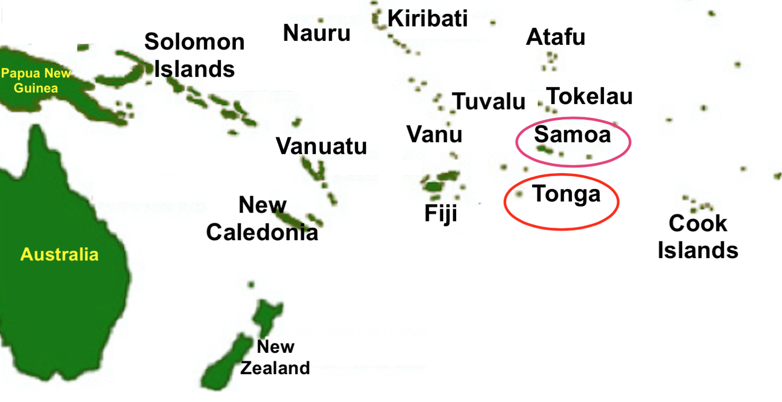
At 552
miles apart, Samoa and Tonga reside in Western Polynesia: Dk Red Circle: Samoa,
one of its islands is the largest in the South Pacific, and were originally called
Navigator Islands, because of Samoan seafaring skills, and whom Robert Louis
Stevenson, who lived there for five years, called them “the gentle people”; Red
Circle: Tonga, called the Friendly Islands by Capt Cook, and means “south,” was
well known before the Europeans arrived all across the central Pacific from
Niue, Samoa, Rotuma, Wallis & Futuna, New Caledonia to Tikopia, suggesting
a heritage connection
Earth’s trade winds and Coriolis Effect force the ocean currents in the South Pacific Ocean to circulate counter clockwise. The term gyre is used to refer to the major ocean systems, and in oceanography is a large system of rotating ocean currents, particularly those involved with large wind movements. Gyres are caused by the Coriolis Effect; planetary vorticity along with horizontal and vertical friction, which determine the circulation patterns from the wind curl (torque).
The point is, these gyres do not change, fluctuate or alternate. As long as the planet rotates on its axis and gravity exists, these major ocean currents are constant and determine, in all reality, where sailing ships (driven forth before the wind) can sail and what paths they can take.
While it is true that within island groups, or from island to island, currents can be found to move contrary to their normal path because of alternating wind currents due to minor changes in heat and cold; however, that is both temporary and extremely limited in distance. The fact is that the overall direction of winds and currents in the Pacific Ocean south of the Equator moves from east to west in the northern rim of the gyre and circles around in the west to then move from west to east in the southern rim of the gyre.
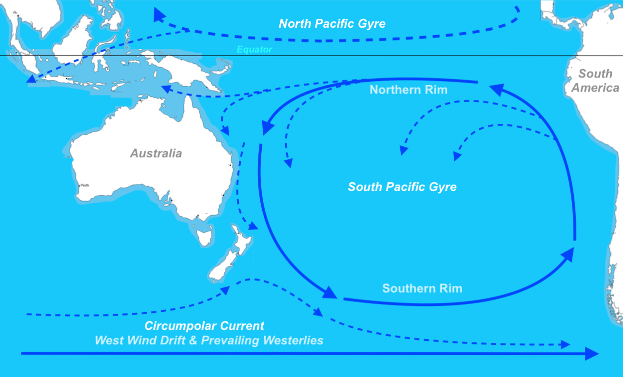
The South
Pacific Circulation Gyre showing the northern rim and southern rim as the gyre
circulates in a counter-clockwise direction in the South Pacific and a
clockwise in the Northern Pacific
In fact, based on NASA’s EOS, NASA Earth Observatory, and the Geostationary Operation Environmental Satellites, and the National Science Foundation, and the National Oceanic and Atmospheric Administration, the major earth currents have been mapped and specifically show the South Pacific Gyre that circles counter-clockwise in the southern hemisphere because of the Coriolis. Effect; with the inner currents breaking off and swinging down into Polynesia.
Early oar driven ships, using sails as an auxiliary means of power, could move across currents and against winds, of course, but such vessels were small and used only for short distance travel. One exception to this is that such vessels, like those of early Polynesian mariners, in moving north and south, cut across currents at times and were able to accomplish longer voyages because of a unique navigating system, evidently known only to them in the form of such famous ones as Pa'ao, Mo'i-keha, Kila, and La'a-mai-kahiki. However, it should be understood their movement was north and south across currents, not west to east against the currents.
While the map above shows north south currents in the sweeping arms of the gyres, such a course from Hawaii to New Zealand, as an example, would have cut across three currents (North Pacific Gyre, Equatorial Counter-Current, and South Pacific Gyre) in the middle latitudes, but then had the South Pacific Gyre’s southern arm for most of the way.
Except for fragments of ancient canoes excavated on New Zealand and pieces of a large canoe recently unearthed from a bog on Huahine, there is no hard evidence, except for a petroglyph on Easter Island, and passing references in the old legends, of Polynesian Voyaging Canoes. It is believed that Polynesian oar-driven “voyage canoes” that moved between Hawaii and Polynesia were swift and with their double narrow design and limited lengths, were capable of cutting cross currents. In addition, there is some small evidence of large canoes, such as the modern performance-accurate replication of a (waʻa kaulua) double-hulled voyaging canoe that was built 17-6” wide from outside hull (gunwale) to outside hull (gunwale), 62 feet in overall length, and a 54’ board deck, 31-foot high mast with spar, and a foresail and aft sail, which could carry 2500 pounds of food, 250 gallons of water, and had a navigational chair hanging out beyond the starboard hull. However, while this is a modern design, it is not known to what extent such a vessel might have been known to Polynesians of the past and at what early date.
While most scientists and historians claim the Polynesians “sailed against prevailing winds to reach new lands,” that is not true. What they did, which was rather unique to navigation before the Age of Sail and the tacking ability of early mariners, was to use the currents in round about patterns—never sailing directly from point A to point B, but using the winds and currents that took them in directions they needed to reach for the next movement in a different direction—sort of like Tarzan swinging on vines through the jungle, i.e., this one takes me there, the next over there, the third elsewhere, etc. And when there was no wind going where they wanted to sail, they had oars, and strong men to use them.
When the Europeans arrived, they found pronounced differences in canoe designs from one island group to another, but each had a double-hull, two sails (some fore and aft, some mounted on separate hulls), and about 25,000 pounds fully loaded.
From these "centers of diffusion" Polynesian explorers reached outward as far as Hawai'i to the north, Easter Island to the east, and New Zealand to the southwest. Before European open ocean exploration began, Eastern Polynesia had been explored and settled. How the first reached Polynesia is unknown to science. They love to say that the Polynesians came from Asia, moving eastward across the Pacific in an “island-hopping” manner; however, while there are many islands, the Pacific is hundreds of thousands of square miles of empty ocean with winds and currents constantly moving against an eastward migration.
(See the next post, “Canoes vs. Immigrant Ships with Families – Part II,” for the difference between Polynesian war and voyaging canoes and those ships Hagoth built in which families migrated)


No comments:
Post a Comment