

Timna in Yemen along the Frankincense
Trail through which Lehi passed, and Salalah, Lehi’s Bountiful
Today Phillips is known, according to Max Kutner of the Smithsonian, and a staff writer for Newsweek, as “the archaeologist who started archaeology in the Arabian Peninsula, opening the door for all archaeologists who came after him.”
Beyond the port of Aden in Arabia stretched the little-travelled hinterland of the British colony Yemen, a land of desert tribes and potential petroleum wealth, long before the area became a separate country. This ancient, formerly fertile land once called Saba (Ramlat al-Sab'atayn, known to medieval Arab geographers as Ṣayhad, or Sheba in Hebrew)—the oldest and most important of the South Arabian kingdoms—was the area of the famed Queen of Sheba (Unnamed in the Bible, but called Makeda in Ethiopian tradition).
The large and prosperous kingdom of Saba' (Sheba), founded in the 10th century BC and ruled by Bilqis, the queen of Sheba, among others, was known for its efficient farming and extensive irrigation system built around a large dam constructed at Ma'rib, about 75 miles east of present-day Sanaa in Yemen. Farther south and east, in the region that would later become South Yemen, were located the Qataban and Hadhramaut kingdoms, which also participated in the incense trade. The last of the great pre-Islamic kingdoms was that of Himyar, which lasted from about the 1st century BC until the 500s AD. At their heights, the Sabaean and Himyarite kingdoms encompassed most of historic Yemen.
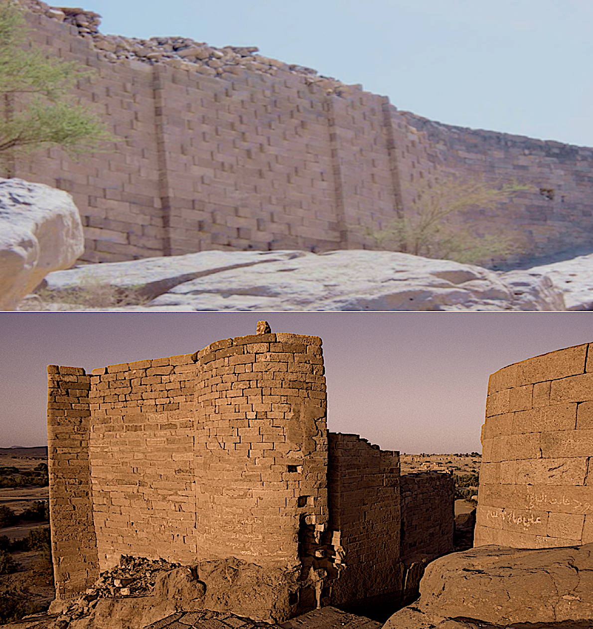
The ancient dam at Sheba, built in
the 1500 B.C. with cut and dressed blocks laid to their ancient height without mortar
According to Dick Parry (Engineering the Ancient World, History Press, Gloucestershire, 2013), “Masonary walls up to 26-feet high formed part of the southern abutment an extended for 197-feet along the channel margins with masonry work of the highest quality and carefully cut and fitted blocks held together without mortar, that lasted for over one thousand years before failing in 575 A.D.”
Also, Thomas J. Abercrombie, an adventurer who had visited all seven continents and seemed to have seen nearly everything on them, from the Empty Quarter of Saudi Arabia to the megaliths of Easter Island, and from the sands of the Sahara to the windswept plains of Antarctica, he excitedly remarked about the construction of the Arsh Balqis (Bar’am) 10th century B.C. temple at Ma’rib in Sheba that revealed “beautifully cut limestone blocks put together without mortar” (Behind the Veil of Troubled Yemen, National Geographic Magazine, March 1, 1964, p409).

Charles M. Doughty on his Arab caravan
disguised as a Bedouin nomad
This Arabian area, of course, is the land that Nephi mentioned when he stated: “And we did sojourn for the space of many years, yea, even eight years in the wilderness” (1 Nephi 17:4) as strangers in a strange land of which none of them had ever before seen. It was a hard and strange land, which gives even more credence to their reaction when they came over the mountains and down into the Salalah Plain along the coast of the ocean they called Irreantum in the country they called Bountiful.
There eventual settlement area of Cuzco and the original so-called “county” land of Nephi, was bordered on the north by the Cordillera Vilcabamba; on the east by the Cordillera Carabaya where the Vilcañota mountains run within the borders parallel to the Carabaya River; a mountain knot in the south called the Vilcañota knudo; with the west boundary the Apurimac (“Great Speaker”) river gorge—a deeply-carved river as much as 80-feet deep in a gorge 245-feet wide that can be heard for many miles. Also along the mountains in the south lies the LaRaya pass, through which access to the Cuzco Valley is reached along the Collasuyu Road (a Quechua name meaning colla—"high plain," and suyu, meaning "region," with the road through this area being paved and bound ono both sides by a wall).
Within these “county” limits was the city of Nephi, later called Lehi-Nephi by the Lamanites to signify their victory over the Nephites once Mosiah left (on his way to Zarahemla), and also the evidently temporary city of Shemlon into which the Lamanites moved to vacate Nephi and Shilom for Zeniff and the Nephites.
The actual city of Nephi was located to the far north of this land along the northern rim of the valley, where Shilom was also located. Above these two cities, on the hill (or mountain) looming over them, is where Ammon and his friends spent the night after reaching the valley: “And when they had wandered forty days they came to a hill, which is north of the land of Shilom, and there they pitched their tents” (Mosiah 7:5). And in the morning, “Ammon took three of his brethren, and their names were Amaleki, Helem, and Hem, and they went down into the land of Nephi” (Mosiah 7:6), where they approached the king who was with his guards without the gate of the city, “And behold, they met the Nephite king of the people who were in the land of Nephi, and in the land of Shilom; and they were surrounded by the king's guard, and were taken, and were bound, and were committed to prison” (Mosiah 7:7).
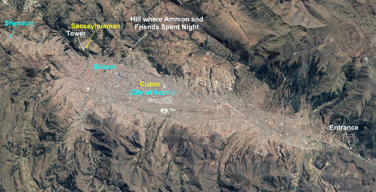
Hill above Shilom where Ammon and his
brethren spent the night before going on down into the land of Nephi to meet
the king


Any proposed location for the city of Nephi should claim that the location at least used to be a walled, gated city.
ReplyDeleteMosiah 7:10 And now, I desire to know the cause whereby ye were so bold as to come near the walls of the city, when I, myself, was with my guards without the bgate?
Here is a link to a drawing of the city of cusco as it was when the spanish chroniclers first saw it. Note that the city is drawn as walled and gated. (you have to scroll down a couple pages)
http://www.wikiwand.com/en/Cusco
The first image of Cuzco in Europe. Pedro Cieza de León. Crónica del Perú, 1553.
Yet another evidence that the Andes area matches the scriptures.
very innovative blog it is useful for all and keep on posting your updates
ReplyDeletehis information is impressive; I am inspired with your post writing style & how continuously you describe this topic.
android training in chennai
ios training in chennai
David: Thanks for the insight. It worked well into an ongoing description of the city of Nephi I was working on.
ReplyDelete