
Comment #1: “No, they did not settle in Peru. The Book of Mormon happened in the Eastern United States. The narrow neck was near Niagara falls. it fits perfectly. Quit looking in the wrong places. They had nothing to do with Peru. They didn't do anything in Mexico or Guatemala either. They were never there. If you believe the Book of Mormon then the land that the United States is on is the promised land. South America is not the promised land and neither is Mexico. Joseph Smith never said that any other place than where he stood was sacred. What you are mistaking as Nephite building is actually pre-flood. Pyramids were made pre-flood on every continent” Michael H.
Response: We deal in more than opinions here. All you have stated are opinions—very strong ones, without one bit of defining or reliance on factual information. Evidently, you have no idea where Lehi settled, or where the Land of Promise was located other than a very firm, fixed, opinion. As for fitting perfectly, we have written on these pages numerous times over the past eight years that nothing in North America fits perfectly with the descriptions in the scriptural record. Beginning with Nephi, and his currents and winds that “driven forth before the wind” match (1 Nephi 18:8,9), to Jacob’s “the Lord has made the sea our path, and we are upon an isle of the sea“ (2 Nephi 10:20), to Mormon’s numerous descriptions, which we will quote just one: “there shall be great tempests, and there shall be many mountains laid low, like unto a valley, and there shall be many places which are now called valleys which shall become mountains, whose height is great” (Helaman 14:23)—there are innumerably more as we have repeatedly pointed out, but simply stated none of those fit North America, let alone perfectly. Touting a mantra is neither beneficial nor advances anyone’s viewpoint.

"This information tends to explain why the Lord declared Far West to be a holy consecrated place; and no doubt explains why Satan claimed that place as his own, as it was here that he entered into a covenant with Cain, resulting in the death of Abel, the first of mortal existence [to die] upon this earth. It would appear that President McKay while there felt the spirit and significance of this holy place" (The Life of Joseph Fielding Smith, p.340). At this spot, the The Prophet Joseph called upon Brother Brigham and Heber C. Kimball, and others, saying, "Brethren, come, go along with me, and I will show you something," He led us a short distance to a place where were the ruins of three altars built of stone, one above the other, and one standing a little back of the other, like unto the pulpits in the Kirtland Temple, representing the order of three grades of Priesthood; "There," said Joseph, "is the place where Adam offered up sacrifice after he was cast out of the garden" (Life of Heber C. Kimball, pp. 209-210).
It is always wise to know what you are quoting and what it means before you begin commenting about it.
Comment #2: “William’s statement says Lehi sailed in a southeast direction when leaving Bountiful and landed in Chile along the western borders of South America. However, if he did that, he would have taken a direct course toward the continent of Australia. Consequently, they would out of necessity had to turn east at some point” Marcus A.
Response: Perhaps you should lay out a map of the Indian Ocean and trace your thoughts out before you write about them. A southeast direction from Salalah in Oman, or the southern coast of the Arabian Peninsula, leads to a point several miles west of Australia. Australia is more east than southeast of Arabia. If you trace a true southeast course from the area of Bountiful to the Southern Ocean, you find it is basically where a ship “driven forth before the wind” would have been driven.
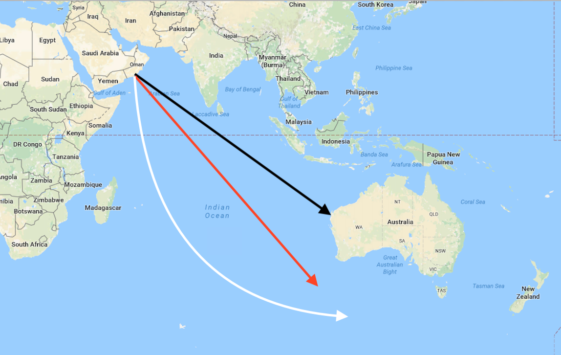
Black Line: Direct course to Australia
from Salalah, along 118º course; Red Line: True Southeast course, at 135º
course; White Line: The path of the ocean currents through the Indian Ocean to
the Southern Ocean, which is basically an overall southeast direction. Keep in
mind ships in 600 B.C. “driven forth before the wind” follow winds and
currents, not a straight azimuth line
Comment #3: “What makes you think that the narrow passage and the narrow neck of land are one of the same?” Doug M.
Response: The Land Southward was nearly surrounded by water except for the small neck of land (Alma 22:32), meaning, of course, that this small or narrow neck was the only land base between the Land Southward and the Land Northward, thus, since the narrow passage also went between the two lands, it had to be within the narrow neck. They are not the same, i.e., the narrow neck is larger than the narrow passage, and the narrow passage may not extend for the entire length of the narrow neck, but since both are the only passage between the two lands, they would have to be within one another.
Stated differently, if travelers were in the Land Northward,, the narrow pass led into the Land Southward; and if travelers were in the Land Southward, the narrow pass led into the Land Northward. And since the narrow neck was the only land connection between the Land Southward and the Land Northward, the narrow pass had to be located in the narrow neck of land; thus all of the Book of Mormon traffic between the land northward and the land southward went through the narrow pass of the narrow neck.
Comment: “Why do you think Nephite building was greater than that built by the Spaniards later on?” Amy W.
Response: There are many reasons, but let’s just center on one that is representative. The foundation walls of the Church of Santo Domingo in Cuzco, Peru, built by the Nephites nearly 2000 years before the Spanish built their cathedral on top of those foundation walls. In 1950, Cuzco was hit with a devastating earthquake that nearly leveled the Church of Santo Domingo, but not a single stone of the foundation walls were altered, tough they were not set with mortar as were the Spanish walls above. This happened three times in the course of severe Cuzco earthquakes.

Top: The Coriancha as it appears
today. The Foundation wall (yellow arrow) survived the earthquake (Bottom:) of
1950 that nearly decimated the Spanish building including all the walls,
Spanish footings, and building, while the Coriancha—the ancient Peruvian
foundation walls and buildings below—were totally undamaged


No comments:
Post a Comment