

In any event, during the night, Teancum and his servants stole into the Lamanite camp, with Teancum killing Amalikiah, and when the Lamanites awoke the following day, with Teancum and his troops encircling their camp ready to do battle, the Lamanites gave up their plan of “marching into the land northward” and retreated with all their army into the city of Mulek, and sought protection in their fortifications” (Alma 52:2).
With Moroni engaged in battling the Lamanites on the West Sea and unable to come to Teancum’s aid, he sent a part of his army to defend Teancum’s force, who was planning to mount an attack against the Lamanites that occupied Mulek, but in the end he gave up the idea because the city was so well fortified (Alma 52:17). Later in the following year Moroni finally arrived in the North to join Teancum (Alma 52:18).

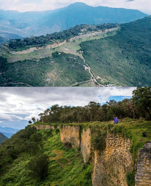
Top: Yellow Arrow: The
fortress of Kuelap (City of Mulek) as it sits atop a ridge above the Utcumbamba
River to the west and the Maranon River to the east. Before the continent rose
and stabilized, the area to the left rising from the canyon in between, where
the (White Arrow) Maranon, was the Sea East in Nephite times, so that Kuelap (Mulek)
overlooked the seashore (Beyond the hill to the left, which is part of
Cordillera Oriental—Eastern Mountain Range—is the Amazonas leading into the
Amazon); Botton: The Maranon River, in Nephite times, the foreground would have
been the seashore and that beyond the river beneath the East Sea—when the
continent rose and stabilized and the Andes came up, the river valley was
created
Seeing
that they could not attack
the Lamanites within the fortifications of the city of Mulek, Moroni and
his
chief captains held a council of war the following year to decide how to
coax the Lamanites out of the city, so they could retake Mulek (Alma
52:19). It is interesting that this
city, originally built by the Nephites, was so strongly defended that it
was
impossible to attack, therefore Moroni devised a plan of subterfuge to
draw the
Lamanites out of the city, which eventually worked. The point is, the
fortification
of the city of Mulek, a northern city along the borders of the Land of
Bountiful, and near the seashore of the East Sea, was the last city the
Lamanites captured in their drive to take the Land Northward.
This is why, once Amalikiah had captured Mulek, his path to the Land Northward was open as they marched to the borders of the Land of Bountiful, driving the Nephites before them and slaying many (Alma 51:28), and was so disappointed when Teancum arrived with his army to head them in their forward and northward progress (Alma 51:29).
As Mormon states it: ”And it came to pass that he [Teancum] headed Amalickiah also, as he was marching forth with his numerous army that he might take possession of the land Bountiful, and also the land northward” (Alma 51:30). Thus, Teancum, when he headed or cut off Amalickiah’s march to the narrow neck and Pass, was north of the City of Bountiful, but still within the Land of Bountiful.
One can imagine how disappointed Amalikiah would have been, having marched all the way up the east coast, taking one city after another in his unopposed race to reach the Land Northward and occupy the northern lands beyond the Nephites, when so near his prize, his worst enemy shows up with his army to cut him off from his objective. As Mormon states it: “But behold he [Amalikiah] met with a disappointment by being repulsed by Teancum and his men, for they were great warriors; for every man of Teancum did exceed the Lamanites in their strength and in their skill of war, insomuch that they did gain advantage over the Lamanites” (Alma 51:32).
Top:
The fortress of Kuelap that sits atop a ridge of a steep sided Andean mountain
with perfect views in all directions of the valleys below; Bottom: The
formidable and unscalable walls of Kuelap, the City of Mulek. It is not difficult
to see why both Teancum and Moroni realized they could not attack the Lamanites
entrenched in the captured city, so well defended was it
Yet, despite the extensive size, there were only three entrances to the fortress, two on the east and one on the west, and each was very narrow and easily guarded against any attack.

Two of the entrances—all three looked much the same, were very narrow
and lengthy corridors that had to be climbed several feet in height that led to
the eventual top of the city. Defenders could stand on the top and drop rocks,
shoot arrows or throw stones with their slings down upon an approaching force, that could only approach
within the entrances one or two abreast; Top: Outside entrances; Bottom: Inside
view of both entrances


Top: The ruins atop Kuelap, within the walls, numerous circular
buildings in various stages of repair; Bottom: An artist’s rendition of the
appearance of the city with all the ruins placed as separate houses for the
occupants. It could have held a large city population, or a large garrison
population, or a combination of both
Whether Kuelap is the ancient city of Mulek, we may never know, certainly there will be no signs anywhere to tell us as critics always expect us to provide; however, we can see that it fits all of the criteria surrounding Mulek’s many descriptions and has the appearance of a city built for the purpose of defense as Mormon describes to keep the Lamanites and any defector from reaching of the Land Northward.


Pretty amazing defensive structure
ReplyDeleteI think a primary impediment to understanding BoM Geography (at least in my case), is that in the modern world of paved super highways and bridges, most geographical "barriers" are no longer barriers to movement. You can now drive around features, such as the Grand Canyon, in a matter of hours instead of the many days/weeks it would take by wagon or pack train.
ReplyDeleteYou can drive from the US West Coast to the East Coast in a couple days instead of the months it would take a wagon train.
Even the most desolate stretch of road is not that far from the next convenience station where you can pick up gas, food, and filtered water, instead of being required to load up barrels of water and food for yourself and your animals for your entire trip.
A "modern" mind may not even notice or think of the landscape as anything other than background.
Michael: That is the exact point we have been trying to make for a long time. We simply cannot truly appreciate the difficulty terrain and distances presented to ancient peoples when it is rarely considered in our time. Thank you for your keen insight.
ReplyDeleteGreat research Del. I went through Priddis book and wrote down what she thought were BOM cities of the Jaredites and Nephites. There are a number of them that are dead ringers such as Zarahelma=Pachacamac. Priddis thought that Chachapoyas was identified with Mulek but your analysis of Kuelap is very compelling. Do you have any kind of list of what you think are good fits? Thanks, Ira
ReplyDeleteModern City Book of Mormon City
Otavalo Ogath
Malchala City Desolation
Riobamba Moron
Salinas Heth
Manta Nehor
Cayambe Shurr
Tabacundo Corihor
city of Nephi Cuzco
Pachacamac Zarahemla
Machu Picchu Amulon
Chanapata Shemlon
Kotoch Lehi
Chavin De Huantar Aaron
Cajamarca Bountiful
Huanuco Nephihah
Izcu-Chaca Minon
Pisco Antiparah
Vilcas-Huaman Sidom
Arequipa Middoni
Tiahuanaco Ishmael
Asillo Jerusalem
Vilcabamba Helam
Pomacocha Ammonihah
Bonbon Jershon
Tarapoto Omner
Chachapoyas Mulek
Hanan-Cuzco Shilom
Huancayo Gideon
Mayoc Melek
Mendoza Omner
Moyobamba Gid
As far as I know, Priddis did her analysis based strictly on location within her assumed map, which may be correct. However, I prefer more compelling comparison, such as the tower base still visible at Sacsayhuaman and king Noah’s tower, the compelling defensive description of Mulek and that of Kuelap, etc. Machu Picchu seems to fit the location of the priests of King Noah when they stole the Lamanite daughters because of the many small, individual house connections that would have served such an immediate beginning of these individual families, its isolated location, where they could hide from both Nephites and Lamanites, etc., as we've written about. but few others seem to suggest a definitive location at this time.
ReplyDeleteThanks Del. From your research how much archaeology has been done on Kuelap?
ReplyDeleteI put this up after studying the Priddis book:
ReplyDeletehttp://2bc.info/pdf/Priddis.pdf
Thank you. It will be interesting to see how many of these can be verified form the scriptural record. My sense is that we do not have enough information on most of this to make such claims, but I could be wrong. It is obvious an area in need of study and comparison.
ReplyDeleteA friend of mine sent me an email with the following info in it.
ReplyDeleteThis is George Potter's version of the City of Mulek.
https://drive.google.com/open?id=0B75Vhjs6vnRkazBad1RjbXhBeFE
Perhaps Potter should be reminded of the scriptural record regarding the city of Mulek: "And thus he went on, taking possession of many cities, the city of Nephihah, and the city of Lehi, and the city of Morianton, and the city of Omner, and the city of Gid, and the city of Mulek, all of which were on the east borders by the seashore" (Alma 51:26). His map and location of TamboViejo is in the south and west--NOT EAST! Why is it so difficult for these theorists to just simply follow the scriptural references in their selection of "candidates" for this place or that?
ReplyDeleteI don't know... I thought I would share what he had to say. At least he is on the right Country. :-)
ReplyDelete