Tuesday, February 28, 2017

A Case for the Need of Intellectual Honesty – Part I

There was a time in our society when honesty was considered a highly prized character trait; contracts were made by a shake of the hand, a man’s honor was tied with his actions, and honorable men were highly prized and rewarded in their life-long pursuits. Today, however, it appears from current events that such honesty is a thing of the past. 
   When Isaiah, looking down the corridor of time, saw our day, he bemoaned the changes he saw, which must have been so unbelievable to him in his day, that he diverted his attention away from writing about the Savior and his birth and mission, to discussing that in that future day—our day—people would “call evil good, and good evil” and would “put darkness for light, and light for darkness; that put bitter for sweet, and sweet for bitter!” (Isaiah 5:20). He also said, “Woe unto them that are wise in their own eyes, and prudent in their own sight"…and “Which justify the wicked for reward, and take away the righteousness of the righteous from him!” (Isaiah 5:21,23).
He saw a world turned upside down in terms of values, character, and virtues. Later, Paul, writing to Timothy, said similarly of the future, “For men shall be lovers of their own selves, covetous, boasters, proud, blasphemers...unthankful, unholy” (2 Timothy 3:2).
    Unfortunately, we are seeing those prophecies unfold before our very eyes. In our own society today, it is very difficult to trust anything the news media reports, for truth is no longer a virtue, only espousing one’s personal views. We find that so many people, even those who in many other areas of their lives are honorable, or at least upstanding, presenting their opinions in lieu of the facts of a situation. Regrettably, we are seeing today how that even includes reporting on, or writing about, historical events. In fact, reversing the icons of the past, such as Washington, Jefferson, or Lincoln and changing them into flawed men with personal agendas that were neither honorable nor virtuous. The Savior, Jesus Christ, is relegated to a mere mortal; Washington to a bumbling officer who lucked out in the end; Shakespeare to an immoral man who didn’t really write many of his works; Columbus to a debased murderer of indigenous Americans, etc.
    We also find that modern thinking places people like Marilyn Monroe as the most famous person in all of history, and others like John M. Keynes, Leo Tolstoy, and Bill Gates as far more famous than Franklyn D. Roosevelt; Oprah Winfrey more than Walt Disney; Peter Sellers more than Ernest Hemingway; John Lennon more than Henry Ford; Angelina Jolie more than Mary Magdalene, etc.
    We live in a very unusual world today. But more importantly, we live in a world with values far less worthwhile than in the distant past. There was a time when what was written in scripture was held in high esteem. Not so today. Most of the modern generations have no idea what is written in scripture, nor what it means--many don't even know their own near history, unable to identify icons of the past and events within their own lifetimes.
    We only need look at the Book of Mormon and the various theories that have evolved over the past 50 years or so from “scholars” who feel their view point is more correct than what is actually written in the scriptural record and the viewpoint of Mormon who was there.
McKane’s (white circle) “I think land” where he has decided that Nephites and Lamanites must have lived West of the West Sea, despite not a single suggestion or reference in the entire scriptural record of anything being west of the West Sea

    As an example, David McKane in his “I think” tendency, writes: “As far as the Nephites and lamanites being west of the West Sea (Lake Michigan) I think the Nephites occupied this area after Christ visit and there being 200 years of peace with no difference in Lamanites and Nephites.” However, neither Mormon nor any other Book of Mormon writer ever says anything existed beyond the West Sea, nor did they even suggest such an area existed.
    John L. Sorenson, the guru of Mesoamerican Land of Promise theory, who claims, despite Mormon’s insistence on a north-south land layout of the Lamanite-Nephite lands, creates a model that runs east and west—claiming that Mormon meant east and west, not north and south.
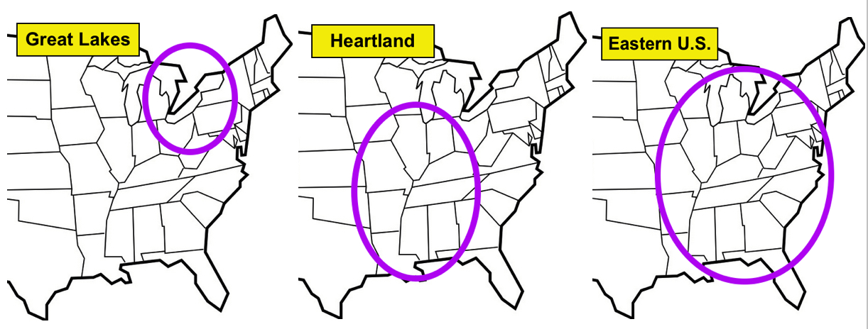
    Phyllis Olive Carol, the early champion of the Great Lakes model, who decided that the location of the hill Cumorah in western upstate New York was the place to begin looking for the Land of Promise despite the fact that Nephi tells us that his ship was “driven forth before the wind” and the sea currents from the Arabian Peninsula went southeast down into the Southern Ocean which curved upward along South America and the winds and currents died at the 30º South Latitude—the very place Frederick G. Williams, a member of the original First Presidency, claimed, and Orson Pratt championed, as being where Lehi landed.
    While anyone can  have an opinion, it is foolhardy to develop an opinion that does not agree with the scriptural record, then insist it is correct and the scriptural record, therefore, must be wrong.
    Take McKane’s comment on his website: “The Adena (Jaredite) culture ending at 200BC is a Book of Mormon match.”
    Response: This is not a Book of Mormon match. In the Book of Omni, we learn that Mosiah left the city of Nephi in 205 B.C. Even if it took him a full year to get to Zarahemla (200 B.C.), which in no way would have taken so long, chief Zarahemla showed Mosiah a stone that Coriantumr, king of the Jaredites (Ether 12:1) had carved about the history of his people (he being the last, surviving Jaredite). Given the time it would have taken for all the flesh to have decayed off the bones of thousands or millions of Jaredite dead (Mosiah 8:8), the handles of swords to disintegrate (Mosiah 8:11, and sword blades to canker (Mosiah 8:12) and the time it took between Coriantumr killing Shiz (Ether 15:31), and his arriving among the Mulekites in Zarahemla, i.e., to get from the hill Ramah (in the Land Northward) where the Jaredites were annihilated, to Zarahemla, and then for the nine moons (months) to pass before Coriantumr’s death, these events do not line up. No Jaredites could have been alive in 200 B.C., in this case, not even Coriantumr, since the time that would have to be allotted would be close to 100 years, making the Jaredite collapse and annihilation no later than 100 years before the disappearance of the Adena Mound Builders.
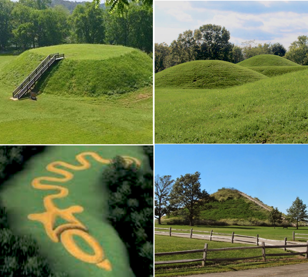
The Grave Creed Mount, in Moundsville, West Virginia, an Adena Mound site—far from the Land Northward which is where the Jaredites were located

    It might be noted, however, that the National Register of Adena Mound sites lists their existence from 800 to 100 B.C., and the Adena Grave Creek Mound is said to have been built from 250-150 B.C. (Grave Creek Mound Archaeological Complex, The West Virginia Division of Culture and History, 2015), making the above dates even more out of line with the scriptural record.
    Yet, even when such errors are pointed out, his reply, “My model still stands its in America,” shows a lack for facts and a tenacity to hold onto a previous belief.
    Or there is Ralph A. Olsen who places the Land of Promise in Malay, Indonesia, despite the fact that Moroni told Joseph Smith that the people of the Book of Mormon were in the Americas, i.e., “an account of this continent’s former inhabitants” (Joseph Smith History 1:34-35). Evidently, however, that fact today, directly from the Angel Moroni, has little bearing on a person’s personal opinion.
The four seas of the Mesoamerican models, both showing the Pacific Ocean as being two different seas, and neither having the Land Southward surrounded by water except for the small or narrow neck of land

    Or Stephen L. Carr and Douglas Christensen, BMAF, who claim that their Mesoamerican model has “the four seas called for in the record: Sea East, Sea West, Sea South and Sea North.” However, they fail to mention that one of the seas is the same sea, the Pacific Ocean, but just simply calling it “south” in one place. However, the scriptural record makes no such differentiation, i.e., there is not a North Sea and South Sea that is the same sea, nor a West Sea and South Sea that is the same sea.
    And, as one counter-theorist mentions, the Mesoamericn model of the Land Southward (and this is true of all Mesoamerican models) is not surrounded by water. Yet despite that fact, the response is that it would have appeared to its inhabitants to be surrounded by water.
Gulf of Tehuantepec, merely an extension of the Pacific Ocean, and in no way could be considered a separate sea or one that divides any land area at all—despite modern day language, there is no way this water would have been thought of as dividing a land area in the B.C. era. Without aerial photography or satellite views, this (red line) could hardly be seen on the ground as anything but a curvature of the seashore, not a separation of land

Or Ted Dee Stoddard and Lawrence L. Poulsen, in the Mesoamerican model, claim that the “Sea Divides the Land” is an area along the Gulf of Tehuantepec, as they write: “We hypothesize that “the place where the sea divides the land” is the Coatzacoalcos River basin on the northern half of the Isthmus of Tehuantepec.” (Analyzing “The Place Where the Sea Divides the Land” and the “Great City” of the Jaredites, BMAF, 2011). 
    In the Jaredite B.C. era, these two scholars are claiming the Jaredites saw this area of water as dividing the land—at a time when to them, there were not two lands. The idea of a Land Northward and a Land Southward, was obviously introduced by the Nephites and does not appear in scripture until long after the Jaredites annihilated themselves. To comment today about this being a land division, and strictly a figurative one, is foolish and obviously not suggested in the Jaredite writing except where the abridger, Moroni, inserts it into his explanation on four occasions (Ether 9:31-32; 10:19,21) from his much later vantage point.
(See the next post, “A Case for the Need of Intellectual Honesty – Part II,” for more on this subject and how it is effective an understanding of the Book of Mormon and the location of the Land of Promise)

Monday, February 27, 2017

Visual Map of Alma 22:27-34 and Other Scriptural References – Part II: The Mountains

Approximations of the locations of the three North American theories involving the present-day area of the United States: LtoR; Great Lakes; Heartland; and the Eastern U.S. Land of Promise theory locations
The visual map of the South American Land of Promise was shown in the preceding post, Part I, and here we continue with the height of mountains in the Heartland, Great Lakes and Eastern U.S. Land of Promise theory locations:
    The Lord put it in the heart of Samuel, the Lamanite, to prophecy at the time of Christ’s death, that during the three hour period following, mountains would tumble and fall forming valleys, and valleys would raise up and become mountains, whose height is great!
The Lord put it in the heart of Samuel the Lamanite what to say,and so important was the message that the Lord caused the stones and arrows directed at him by an angry crowd to miss him so he could complete the message
 Whose height is great,” is a statement of fact, not just an idea or catchy phrase. Nephi, in his vision of the Land of Promise at the time of the crucifixion, acknowledged all the damage and changes, even the mountains that they existed in the land “tumbling into pieces” (1 Nephi 12:4). Now what is meant by “whose height is great”? Would that mean small hills, low mountains, those that are hardly noticed? Or would it mean mountains that are so tall and numerous that all within the Land of Promise could readily identify their sudden existence and that it was the sign Samuel prophesied?
    In North America, in the United States, the tallest single mountain is Mt. Whitney, at 14,505-feet; the tallest ranges are the Sierra Nevada Mountains of California, of which Mt. Whitney is a part; then comes the Rocky Mountains, with Mt. Elbert at 14,433 feet, which is within the Sawatch Range in Colorado, which also has eight of the twenty highest peaks (8 over 14,000-feet, 6 more over 13,000-feet) in the Rockies, 2 over 12,000-feet and 2 over 11,000-feet). Gannett Peak in Wyoming is 13,804-feet; Wheeler Peak in New Mexico is 13,161-feet; Mt. Humphreys in Arizona is 12,633-feet and the highest point in Arizona and the Kachina Peaks. Borah Peak in Idaho is 12,662-feet; Granite Peak in Montana is 12,799-feet.
    In addition, the following states are outside the area of David McKane’s Land of Promise:
New York – 5344-feet (Mt. Marcy and Adirondack Mountains)
Vermont 4393-feet
Kansas – 4039-feet
Massachusetts – 3487-feet
Connecticut – 2380-feet
    None of the above are within the land considered to be the Land of Promise by Heartland, Great Lakes, or Eastern U.S. theorists.
Differing heights of the various mountains or top elevations of the lands considered by theorists in the U.S. and Mesoamerica Land of Promise locations as compared to those mountains in the Andes of South America

   By comparison the highest point east of the Mississippi is Mt. Mitchell in North Carolina:
North Carolina – 6684-feet
Tennessee – 6643-feet
Virginia 5729-feet
Nebraska – 5424-feet
*New York – 5344-feet (Mt. Marcy)
Maine – 5267-feet
West Virginia – 4861-feet
Georgia – 4784-feet
South Carolina 3560-feet
Maryland 3360-feet
Pennsylvania – 3213-feet
Arkansas – 2753-feet
Alabama – 2413-feet
Minnesota – 2301-feet
Michigan – 1979-feet
Wisconsin – 1951-feet
New Jersey – 1803-feet
Missouri – 1772-feet
Iowa – 1670-feet
Ohio – 1549-feet
Indiana – 1237-feet
Illinois – 1257-feet
Rhode Island – 812-feet
Mississippi – 806-feet
Delaware – 448 feet
District of Columbia – 410-feet
Florida – 345-feet
    Now, to reiterate, the six states that David McKane claims make up the Land of Zaraahemla and the Land of Bountiful (Nephite lands), the highest area is 1979 feet in Michigan (Land of Bountiful)—and the three main states of the Land of Zarahemla, the highest point is 1549-feet):
The comparison between the highest point in all of the Eastern U.S. is only 6684-feet, which would be in McKane's Land of Nephi; but in his Land of Bountiful, only 1979-feet, and in his Land of Zarahemla, only 1772-feet--none of these figures could be considered "whose height is great" to the Lord; however, Andean South America at 22,841 would be considered not only by the Lord, but by anyone as "whose height is great"
 
Michigan – 1979-feet
Missouri – 1772-feet
Iowa – 1670-feet
Ohio – 1549-feet
Indiana – 1237-feet
Illinois – 1257-feet
    Thus, one of the simplest tests of David McKane’s Land of Promise, the mountains “whose height is great” manages an elevation for the entire state of no higher than 1549-feet. How anyone can claim such a location is so far beyond my imagination I cannot fathom the ignorance (lack of knowledge) involved.
    For a comparison of the Andes Mountains and their height:
• There are 72 mountains over 20,000-feet
• 170 mountains between 18,000 and 20,000, or 242 mountains over 18,000 feet in height
• 490 mountains between 14,511 to 18,000 feet.
    This means in the Andes there are 732 mountains taller than the tallest in the United States, the shortest of these Andes is still 7,827 feet taller than the highest mountain in the eastern U.S. within the land claimed by David McKane as his Land of Promise (and that is North Carolina), and 16,490 feet taller than the highest mountain within McKane’s Land of Zarahemla and Bountiful.
    Now David McKane tells us in answer to where is his mountains, that: “There are three major mountain ranges in New York: the Adirondack Mountains, the Catskill Mountains, and part of the Appalachian Mountains. Mountain ranges in Tennessee Blue Ridge Mountains‎, Great Smoky Mountains‎. Mountain ranges of Missouri Ozarks‎, St. Francois Mountains‎ , U.S. Interior Highlands‎.
    As stated earlier, the highest point in the Adirondacks (Catskills) is Mt. Marcy at 5343 feet, and is the highest point in New York state, but is not in the area of McKane's Land of Promise Land Southward (Land of Bountiful, Land of Zarahemla, or Land of Nephi, and is even outside the area of McKane’s east wilderness beyond the Sea East. Blue Ridge is Mt. Mitchell at 6684 feet (not in Tennessee, but in North Carolina) which is far east of McKane’s Land of Nephi. Great Smoky Mountains is Clingmans Dome (in Tennessee) in the heart of McKane’s Land of Nephi. The Missouri Ozarks is Taum Sauk Mountain (in the St. Francois Mountains) at 1772 feet, but this is in the southwest part of the state, out of the area of McKane’s Land Southward. As for the U.S. Highlands, they are in Oklahoma and Arkansas and southern Missouri, all areas outside McKane’s Land of Promise—even so, the highest points are in the Boston Mountains at 2,560 feet.
    Obviously, we are not talking here about mountains “whose height is great,” or anything even remotely close to it, which by definition, should disqualify McKane's location for the Land of Promise in the eastern U.S. Of course, it will not, because theorists like McKane simply ignore those areas of their beliefs and models that do not agree with the scriptural record and Mormon's descriptions of the Land of Promise.

Sunday, February 26, 2017

Visual Map of Alma 22:27-34 and Other Scriptural References – Part I: The Map

We have been asked from time to time, and most recently by David McKane, to publish our map of the Land of Promise using the locations indicated in the scriptural record. Following is that map.
The important thing to keep in mind is that prior to 3 Nephi Chapter 8 (34 A.D.), the area to the east of the Andes was underwater as most of the Continent was just below the surface—in fact, much of the Amazon Basin is still just underwater, especially at certain times of the year

    When the West Andean Escarpment (WARP), which by the way, “reveals episodes of uplift, erosion, volcanism and sedimentation—meaning it was uplifted from beneath the ocean” and “suggesting that recent uplift is at least partly caused by regional tilting of the Western Andean slope” and that “erosion has been extremely slow over the past…even though tectonic movements created a steep morphology” (Gerhard Wörner, et al, Andean Geodynamics ISAG4, Tectonophysics, Vol 345, Is 1-4, Stuttgart Germany, 2002, pp183-198), and finally “90% of the volume, however, erupted very close in time” (G. Wörner, K. Hammerschmidt, F. Henjes-Kunst, J. Lezaun, H. Wilke, Geochronology ages of Cenozoic magmatic rocks from Northern Chile: implications for magmatism and tectonic evolution of the central Andes, Rev. Geol. Soc. Chile, 2000, pp205–240).
Note: It should be kept in mind that these references are from geologists who talk in millions of years, but when overlaid with the Lord’s time as dictated to Moses in Genesis and the Pearl of Great Price, equate to a very short time and quite recently.
    Thus, the continental Shelf raised as the result of plate-tectonic forces that resulted in the orogenic, or mountain-building activity that produced the Andes, in a short time and recently. With the Andes “popping up” this also tilted the western slope of the continent from the Andes toward the Pacific Ocean, causing the continental divide and numerous rivers emptying into the Pacific while others emptied into the east, mostly through the Amazon Drainage Basin.
    When the Lord told Samuel the Lamanite to return to Zarahemla and speak the words he would put in the Lamanite’s heart (Helaman 13:3), Samuel climbed upon the Temple walls where Nephite arrows and stones were unable to strike him, and stretched for his hand, saying:Behold, I, Samuel, a Lamanite, do speak the words of the Lord which he doth put into my heart; and behold he hath put it into my heart to say unto this people…(Helaman 13:5)…”Behold, I give unto you a sign; for five years more cometh, and behold, then cometh the Son of God to redeem all those who shall believe on his name” (Helaman 14:2)…”And behold, again, another sign I give unto you, yea, a sign of his death. For behold, he surely must die that salvation may come; yea, it behooveth him and becometh expedient that he dieth, to bring to pass the resurrection of the dead, that thereby men may be brought into the presence of the Lord” (Helaman 14:14-15)…”behold, in that day that he shall suffer death the sun shall be darkened and refuse to give his light unto you; and also the moon and the stars; and there shall be no light upon the face of this land, even from the time that he shall suffer death, for the space of three days, to the time that he shall rise again from the dead” (Helaman 14:20)…”And behold, there shall be great tempests, and there shall be many mountains laid low, like unto a valley, and there shall be many places which are now called valleys which shall become mountains, whose height is great” (Helaman 14:23).
    Now these signs and many others will be given “to the intent that they might believe that these signs and these wonders should come to pass upon all the face of this land, to the intent that there should be no cause for unbelief among the children of men” (Helaman 14:28).
    Thus, the Lord told Samuel to prophesy that at the time of Christ’s death, and during the three hour period mountains would tumble and fall forming valleys, and during the three day period, valleys would raise up and become mountains, whose height is great!
    Many people, even Latter-day Saints, have difficulty accepting that prophecy of the Lord through Samuel. 'How could huge mountain ranges rise up to great heights in just three days?' they ask. Much doubt is expressed because of the public belief, fostered by godless men in science who claim the Earth is 4.55 billion years old, and that it takes millions and millions of years for mountains to form, that fosters a reluctance to accept the fact that the Lord said this would happen…
    And very obviously, it did!
    And in a very short time!
    And at the time of the Lord’s crucifixion!
    We have written in this blog several times the science behind how this happened, even the steps of the mountains coming up and the speed at which they did and how it happened. The point is, the Lord said it would happen and obviously it did.
    The map above is based on Alma 22:27-34 in which:
1. Land of Nephi and Land of Zarahemla Separated: [The Land of Nephi] which was bordering even to the sea, on the east and on the west, and which was divided from the land of Zarahemla by a narrow strip of wilderness, which ran from the sea east even to the sea west…(Alma 22:27a)
2. Wilderness Extended up and Both Seashores “Roundabout”: …and round about on the borders of the seashore, and the borders of the wilderness which was on the north by the land of Zarahemla, through the borders of Manti, by the head of the river Sidon, running from the east towards the west -- and thus were the Lamanites and the Nephites divided” (Alma 22:27b)
3. Lamanites Occupied the West and East Wilderness: These areas are where the Narrow Strip of Wilderness, running from the east sea to the west sea (Alma 22:27) curved up, or continued “round about” (which means “curving” northward along both seashores, thus the Lamanites lived in tents in those continuing wilderness areas (Alma 22:28a).
4. Land of First Inheritance: This is the area where Lehi landed, which Mormon addresses as “in the borders by the seashore, and on the west in the land of Nephi, in the place of their fathers' first inheritance, and thus bordering along by the seashore” (Alma 22:28b, 29a).
5. Sidon River: The river has its head (beginning or source) in the narrow strip of wilderness just below where the arrow points on the map and runs northward through the Land of Zarahemla (Alma 22:29), curving toward the Sea East and emptying into that sea before the destruction in 3 Nephi 8. Today, that river has four different names and eventually runs into the Amazon River.
6. Land South, Land North: When the Gaddianton Robbers were threatening the Nephites, the governor ordered them to congregate in an area, south of the Land Northward, yet when the Robbers came out of the mountains in the land Southward (3 Nephi 3:24), they took possession of the land South and the Land North (3 Nephi 4:1); Moroni named “all the land which was south of the land Desolation, yea, and in fine, all the land, both on the north and on the south -- A chosen land, and the land of liberty” (Alma 46:17, emphasis added), and Helaman mentions the Land South and the Land North (Helaman 6:9), because the northern part of the Land Southward (the Land of Zarahemla where Mulek landed) as the Land North, and the the Land of Lehi, where Lehi landed) as the Land South (Helaman 6:10).
7. Land of Gideon: This land of Gideon was in a valley, also called Gideon, where they build a city called Gideon, which was east of the river Sidon (Alma 6:7)
8. Land of Bountiful: This land was north of the Land of Zarahemla and south of the Land of Desolation—on the north, even until they came to the land which they called Bountiful (Alma 22:29)
9. Narrow Neck of Land: This small or narrow neck was located between the Land Southward and the Land Northward—there being a small neck of land between the land northward and the land southward (Alma 22:32). It was also the only land area between the Land Southward and the Land Northward, for the Land of Nephi and the Land of Zarahemla were nearly surrounded with water except for this narrow neck of land (Alma 22:32). Note there is no other exception to the Land Southward being surrounded by water—there is no separate narrow passage mentioned in connection to this
10. City of Desolation: The Jaredites built a great city by the narrow neck of land” (Ether 10:20), and that city was named Desolation, as Mormon places it when he said, “And it came to pass that I did cause my people that they should gather themselves together at the Land Desolation, to a city which was in the borders, by the narrow pass which led into the land southward” (Mormon 3:5), and then named it, “the Lamanites did come down to the city of Desolation to battle against us; and it came to pass that in that year we did beat them, insomuch that they did return to their own lands again” (Mormon 3:7).
11. Hagoth and the Sea that Divides the Land: In the area where the narrow neck is located, the Gulf of Guayaquil cuts in and forms a large sea that divides the Land Northward from the Land Southward, leaving only about 26 miles of land between the Gulf waters and the Andes Mountains now, and what was the Sea East before 3 Nephi 8. Ether tells us that the Jaredite city was “by the narrow neck of land, by the place where the sea divides the land” (Ether 10:20), thus this sea was associated with the narrow neck of land.
12. Hill Cumorah, Land of Many Waters, Land of Desolation: We already know that the Land of Desolation was north of the narrow neck and the Land of Bountiful (Alma 22:31), and that the bones (Alma 22;30) of the dead Jaredites that were never buried (Ether 14:22), and that area was “so far northward” (Alma 22:30), and that the hill Cumorah (which was the same as the  hill Ramah where the Jaredites were also destroyed (Ether 9:3), was in the Land of Many Waters where the hill Cumorah was located (Mormon 6:4).
(See the next post, "Visual Map of Alma 22:27-34 and Other Scriptural references - Part II: The Mountains," for an explanation of the Andes coming up and the height of mountains of both the Land of Promise and the Eastern U.S. for a comparison of mountains in the Heartland, Great Lakes and Eastern U.S. Land of Promise theory locations) 

Saturday, February 25, 2017

A Last Comment from McKane – Part II

Continuing with the Last Comment from David McKane and his 24 questions or comments has has proposed for us to answer. We are keeping our answers very brief per  his request, consequently no support or references are given.
10) Joseph Smith pointed to the Hopewell mounds as the Nephites.
    Response: No, he never said Nephite. Joseph Smith said that Zelph, who was found in what is called Mound 8, or the Zelph Mound, was a white Lamanite—not Nephite.
11) When missionaries were sent to the Lamanites see D&C they were always sent to North American, American Indians.
Response: That is because in the early days of the Church, the Indian Territory was only a few miles distant from the western New York, and later Illinois saints. Central and South America was a long way off for the early Saints, and travel to those areas was most difficult, whereas travel to Europe (England) was quite simple. However, you err in talking about “always sent” since when South America was opened (indeed all of Latin America) it was referred to as the Lamanite Lands outside of the European cities of South America.
12) The church has Identified the hill Cumorah as THE hill Cumorah. It has only one Hill Cumorah visitor center.
    Response: Again, you err. The Church has identified the hill Cumorah in western New York as the hill Cumorah where the plates were obtained by Joseph Smith. They have not referred to it as anything else and certainly not as the hill Cumorah location of the Book of Mormon. Best to know the facts, not opinions.
13) Your East Sea is not supported by Academia. At the time of the BOM your East sea does not exist by millions of years.
    Response: It does in a world that is about 13,000 years old according to the Biblical period Moses gives us and repeats in the Pearl of Great Price. You can take Academia over Moses, but I do not.
My Question to McKane: Since you and I and everyone here, who has come to this Earth and yet will, were at a Grand Council before the foundations of this world were laid (Abraham 3:22-28), do you really think we then sat around for the next 4.55 billion years to wait for our turn to come to this Earth? Really? Also, since we know that Adam was the first death on the Earth (Moses 6:48; 2 Nephi 2:22), all those billions of claimed deaths in the Geologic Column during those 4.55 billion years before man, could not have taken place.
14) Horses no evidence of horses in South America pre-European arrival (Enos 1:21)  
    Response: Again you err. Horse remains have been found in Central and South America. You don’t hear much about it because it is contrary to mainstream Academia, but is evidenced nonetheless. If you reject that, then there are no horses found in North America between so-called extinction time and the European arrival.
15) Cattle no evidence of cattle in South America pre European arrival (Enos 1:21)
    Response: Ditto North America.
16) Goats no evidence of goats in South America pre European arrival (Enos 1:21)
    Response: Ditto North America; however, feral wild goats have been found in South America, not elsewhere in the Americas.
17) Wheat no evidence of wheat in South America pre European arrival (Mosiah 9:9)
    Response: Ditto North America
18) Barley no evidence of barley in South America pre European arrival (Mosiah 9:9)
    Response: Again you err. Barley has been found in South America.
19) Iron Sword no evidence of Iron swords in South America pre European arrival (Mosiah 8:9)
    Response: Ditto North America; however, the most noted metallurgists have all stated that metallurgy began in South America during Nephite and Jaredite times, not so in North and Central America.
20) Breast-plates no evidence of breastplates in South America during BOM timeline (Mosiah 8:10)
Top LtoR: A so-called copper breastplate found in North America--it is so thin it would have provided no protection and was probably decorative; Sioux Indian spiritual breastplate "worn as body armor in battle" but now considered by the Sioux and plains Indians as ceremonial status symbols; Nez Perce breastplate; Cree "bone hair pipe breastplate"; Bottom: Chimu Culture gold breastplate, Northern Peru, South America; Gold Arm Band; Gold Wrist Band; all decorative but also usable
     Response: There is speculation of the dating of the copper breastplates found in North America, but nothing that has been dated to that time. In addition, as stated before, the one sample of a breastplate found in North America is so thin it would never have protected anyone--probably was decorative or ceremonial. As for South America, there have been metal breastplates found in Peru, Colombia (Quimbaya), and Brazil. Also metal headplates, metal arm bands, and metal wristbands. In addition, a fan-like helmet used in battle of the ancient Moche culture, along with copper and bronze breastplates found in Cerro Blanco, Peru.
21) I would like to see a visual representation of all aspects of Alma 22.
    Response: Look on our blog, it has been posted numerous time. Yours, by the way is totally inaccurate as we have shown in our 18-part series answering all your questions in great detail.
22) Generally south and meso American models place Lamanite wilderness always south of Zarahemla. The Lamanites were in wilderness on the South West and East of Zarahemla.
    Response: As our model shows. But what you fail to understand is the word “round about” as indicated in Alma 22:27, which meant in 1828 “curving” and ours shows this curving up along the seashore as Mormon describes, which is the essence of the wildernesses in the east seashore and west seashore—and, contrary to what you show, not east of the Sea East and west of the Sea West, but in between the seas.
23) You have Zarahemla close to the shoreline. But when Hagoth launches his ships him and thousands of men women and Children leave the Land of Zarahemla go by the Narrow neck and launch their boats. Why wouldn’t Hagoth launch from the Land of Zarahemla. In your model Zarahemla is closer to the shoreline than bountiful is.
Response: First of all,as we have shown numerous times, Hagoth never left in one of his shipsbefore claiming he did, read the scriptural record. Second, Hagoth built his shipyard near the narrow neck of land (Alma 63:5) and launched from there. The narrow neck, by definition, would have provided an inlet, bay or gulf, where ships being built, launched, repaired, etc., would require calm waters and protection, which the narrow neck would have provided. Zarahemla did not have such an environment. It is not rocket science but common sense to a mariner.
24) Hill Cumorah is in the South Countries Mormon ask the lamanite King permission to enter the Land of Cumorah essentially making one last stand.
    Response: This is a very ignorant (lacking in knowledge) comment. Cumorah was in the Land Northward, in the Land of Cumorah, in the Land of Many Waters, north of the land of Desolation (which was “so far northward” as we have explained several times in our 12-part series answering your questions—repeating the same erroneous information as you do over and over again does not change the facts of Mormon's writing).
25) Why didn’t the Nephites continue to migrate north when they knew they were outnumbered and would lose to the Lamanites.
    Response: too bad you have not read our blog which has shown this in numerous articles. However, the Andes mountains to the east and north of the Land Northward imnpeded any movement over them and, in fact, were never breached by man until the advent of airplanes (to the east) and building of roads and railroads and tunnels (to the north). Before the mountains came  up, the land was separated from Central Americas. It was an island as Jacob stated (2 Nephi 10:20).
26) A continued migration north would be their best option to preserve life. The land northward did not have Lamanites. With your model there would be no issue with a continued Northward migration (Alma 22:29, Mormon 6:2)
    Response: Again, you err. Even if the mountains to the north could have been breached (no one had ever done so until the Spanish arrived) there was the Darien Gap, which still exists and no one has ever penetrated that north to south or south to north except in four wheel vehicles, and then barely and with enormous difficulty, requiring boating at times to get around impossible passages.

Friday, February 24, 2017

A Last Comment from McKane – Part I

McKane writes: Del these are some of the issues I have with your model. I would appreciate short concise answers if you choose to respond to these questions. Long drawn out answers are painful to read. If you cite North America for answers to items not found In south America that only supports North America models not South America.
1) Any evidence of migrating beast in South America (Alma 22:31)
    Response: Alma 22:31 is not about migration but about animals being driven out of the Land Northward by poisonous serpents; from that point on they simply spread throughout the open land as basically all animals would do over the ensuing 1000 to 1200 years.
Since the Lord caused the serpents and the animals to be driven out of the Land Northward into the Land Southward it would be safe to assume that the Lord was also responsible to see that these animals reached the landing sights of Mulek and Lehi. Every zoologist speaking about South American animals will tell you they came from the Great Animal Interchange and migrated (or spread) throughout the continent.
2) Head-plates no evidence of Head-plates in South America during BOM timeline (Alma 43:38)
    Response: The Etowah Mounds in Georgia, with a copper breastplate (found in Mound C) have been dated to 950 A.D. to 1450 A.D., with a date of 1250 most likely. In addition, as has been pointed out in earlier responses to your comment about breastplates, we showed a picture of the breastplate that is so thin, it would not have been any protection to the wearer and was most likely a ceremonial breastplate, not a protective one as Moroni caused his army to wear. As for other so-called breastplates, one engraving showed a mound that had a ditch around three sides and a palisade wall for protection. On a stone engraving a figure is either holding a tablet or wearing a breastplate in a Hopewell Mound in Ohio, which may have been dated as late as 500 A.D. Copper breastplates claimed to be found in Florida, undated but believed to be pre-Columbian. Copper breastplates in the Seip Mound in Ohio believed to be A.D. period, and could be as late as 500 A.D. In some works this culture is thought to have been from 100 B.C. to 500 A.D., but no dating verification is given, and all information available and, in fact, their “existence is still under discussion,” which means they are using archaeology “traditions” which arbitrarily give dates to things found by subject, not by any factual dating method. According to the history made for them (no records exist to show anything factual), their mounds were “built for uncertain purposes.”
Their “gigantic sculpted earthworks often took the shape of animals, birds, or writhing serpents” (Gary B Nash, Red, White and Black: The Peoples of Early North America, Los Angeles 2015. Chapter 1, p6). 
Many mounds are effigy mounds, i.e., depictions of various animals or designed. Top: a serpent; Bottom Left: a land animal, such as a buffalo; Bottom Right: a bird
Archaeologists have created an entire “Hopewell Exchange System,” claiming they traded all over the United States based solely on finding certain artifacts in burial mounds, which could have been produced locally by different groups or migrants from groups. Some claim they began in Illinois and some claim they began in New York. It is claimed they built defensive walls, yet it is also said of them that they did not have rulers who commanded armies (Hopewell Culture, Ohio History Central. Ohio Historical Society).
    Note: In South America, archaeologists use carbon-14 dating on all locations, artifacts, and ruins; in North America, especially in the Mound cultures, archaeological dating methods are used, i.e., not finding any pottery shards gives a time frame of Pre-ceramic, i.e., which determines the date period, not a specific dat--and there is no guarantee that the culture never had pottery, only that no pieces were found.
3) West Lamanites lived in tents any evidence of South American indigenous population that lived in tents (Alma 22:28)
    Response: You have got to be kidding! Nobody, except through speculation and opinion, could ever say somebody lived in tents in any area of the past where there is no continuing occupation—tents simply do not last 1000 to 2000 years, nor do they leave evidence of their past use. Not even wood structures will survive that long. Your question and stance on this is both ill-founded and without scholarly merit.
4a) The Nephite building structure is wood. When timber was low they used cement in the Land Northward. (Helaman 3:7) 
    Response: Helaman 3:7 has to do only with those who occupied the Land Northward in the last century B.C. There were no trees to obtain timber. Timber is needed in all construction, whether stone buildings, mud brick buildings, or cement., as framing, stairs, roofing structures, etc.—even Solomon’s Temple had wood beams brought from the land of Lebanon, and wood paneling (though this was covered in gold). However, you err in saying the Nephites built only of wood. 
All ancient building materials included wood, whether the house was made of mud brick, stone or cement--especially the 600 B.C. style houses that were built by the Hebrews around Jerusalem as shown here. Some of these houses could not have had two stories, roofs, stairs, or other framework without wood and why it was so important to those who went north into the Land Northward in building their houses
The Nephites were Hebrews (what are called Jews today) with 500 years culture behind them when Lehi arrived in the Land of Promise. Their land from which they came was all built of stone (though wood was also used as mentioned above). Lehi’s house outside Jerusalem would have been built with stone, just like all the others.
    In South America (Ecuador, the Land Northward) there are numerous evidences of ancient ruins of cement use.
    The only mention of timber besides the Land Northward has to do with defensive walls—there is no mention of building with wood anything else in the Land Southward
4b) Any South American tribes that used timber for the houses buildings and temples.
    Timber was plentiful in Andean South America and no doubt many early tribes did, there is much evidence of wood used in connection with stone and other materials.
4c) Note that the Book of Mormon never states that the Nephites or Lamanites built there building from stone.
    Response: Note that the Book of Mormon never states that the Nephites built there houses out of only timber, or that any houses were built out of timber in the Land Southward.
    Note: Mormon writes: “building walls of stone to encircle them about, round about their cities and the borders of their lands; yea, all round about the land” (Alma 48:8). The Nephites used stone a great deal and were well familiar with it.
5) Shipping the Nephites shipped timber to the land northward because of the lack of timber how do you suggest this was done in South America. Specifics like which river would be helpful. (Helaman 3:10).
Left: Map of Ecuador. Dark Blue Lines show the major rivers that flow into the Gulf of Guayaquil, including the Guayas, Jubones, Zarumilla and the Tumbes rivers; Right Top: The Guayas River; Right Bottom: The Jubones River. The Gulf of Guayaqui is where Hagoth's shipyard would be, and wood could be shipped to any part of the Land Northward from that point
 
    Response: You seem to love to speculate. Well, I’ll speculate right along with you—in Ecuador, the Land Northward, moving from the south to the north, from the Gulf of Guayaquil (where Hagoth's shipyard was located), there is the Guayas River, Jubones River, Zarumilla River and the Tumbes River, all of which are large, major rivers and capable of having a sea going ship to sail far northward into the area. An interesting river system exists within Ecuador that stems from an area called “The Land of Many Waters” an area Southwest of Quito covering hundreds of square miles where ships carrying timber would have access to landing along sufficient land areas to cover the entire Land Northward.
6) Earthen mound wall around ALL their cities. Do you have evidence that the indigenous people of South America used earthen mounds around all their cities? (Alma 50:1)
    Response: Do you have evidence that the indigenous people of North America used stone walls around all their cities throughout all the land? (Alma 48:8). We certainly do in South America. Do you have signs of stone walls built from the West Sea to the east that served as defensive walls against a southern attack that stretch for at least a day’s journey of a man? And yes, there are signs of earthen walls in South America. It might also be noted that nearly all the famous mounds of the Eastern U.S. were either “burial mounds” or effigy mounds, or in some cases possibly platform of decoration.
As an example, these mounds in the eastern U.S. are not defensive walls, and neither are
the vast majority of the mounds found in the Eastern U.S. 
7) Timber stockades and evidence the indigenous people of south America during the time of the Book of Mormon or any time for that matter used timber stockades around all their cities. (Alma 50:2). 
    Response: Again, these eastern U.S. mounds are not defensive walls around cities
There is simply nothing in the Book of Mormon to suggest that these earthworks shown here are what Mormon mentions in the scriptural record. In addition, wooden stockade type walls would not last 1000 years and there are no such walls dated to Nephite times in the Eastern U.S. What some writers claim are such walls have been shown by other historians to be far more recent, even as recent as the famed Indian Wars ot the 17th century and later.

8) D&C 54:8 states that Missouri is a border of the Lamanites suggesting one side is Lamanite the other side is Nephites.
9) Joseph Smith has made many statements that North American, American Indians as the laminates. 
    Response to 8 and 9: The Nephites and Lamanites went north in Hagoth‘s ships, settled Central America and North America over time. Nephites and Lamanites would have been found throughout South and North America so it is not surprising that evidence is found in the U.S., and also why several Prophets and General Authorities including Joseph Smith has called the Western Hemisphere the Land of Promise.
(Questions 10-24 answered on the next post)

Thursday, February 23, 2017

Answering a Reader’s Eastern U.S. Land of Promise – Part XVIII

-->Continuing with our final response in this series to David McKane’s comments on our blog and his maps and claimed area for the Land of Promise in the Great Lakes area.     McKane writes: “The St Lawrence seaway is used today for traffic today given the description of the Bro Jared’s ships and how they were driven. The lord could easily allow winds to blow their ships of the ST Lawrence seaway. From what it sounds like they were driven by the winds of large storms that happened during their voyage that included floods it sounds like they were built specifically to travel up the ST Lawrence Seaway.”
    Response: It is always a cop out for theorists to rely on the Lord doing something he normally would not do—like cause winds to blow upward along the St. Lawrence River, which it never does. If we are going that route, just pick up the ship in Arabia and set it down in the Land of Promise.
    The problem with your above scenario is:
1. The St. Lawrence Seaway is only from Montreal to Lake Ontario, an area until the Corps of Engineers and the Royal Army Engineers dug the channel around Montreal, there was no shipping beyond that point;
2. The traffic today is a result of widening, new channels and numerous locks that did not exist before 1824;
Tremendous obstacles to normal navigation, let alone a vessel driven forth before the wind

3. The St.Lawrence River contains, at one point, an area called The Thousand Islands Section, which is an archipelago of 1,864 islands downriver from Lake Ontario, ranging in size from one square foot above the water level to over forty square milesif by some miracle the Jaredite barges or Nephi's ship reached that point, the ability of a wind-driven vessel to negotiate this obstacle course to sailing would be impossible (the river at this point has so many shoals and nearly hidden rocks that even today vessels sailing upriver must use maritime pilots to help them travel through the hazardous waterway);
4. The Jaredites had no ships—they had barges, which were submersible and had no power of their own, being driven strictly by the wind-blown ocean currents;
5. Winds of large storms do not cause current to move, but to circle in turmoil. Strong winds, like trade winds, move currents—they are constant and governed by gravitational pull and numerous of natural factors;
6. There were no floods involved. The word “flood” mentioned in Ether 2:20, is the swamping or flooding of the barge with the hole open to the sea; In 2:24, the Lord is telling the Bro of Jared that he was the cause of the winds, rains and floods that so recently had inundated the earth; In 2:25 the Lord is referring to the winds, rains, and floods that will come forth effective the barges the Jaredites fashioned; In 3:2 the Bro of Jared is referring to the waters that are overwhelming the barges, i.e., submersing the barges into the depths of the ocean. Keep in mind that the word “flood” means “The flowing of the tide; the semi-diurnal swell or rise of water in the ocean; opposed to ebb. The ship entered the harbor on the flood Hence flood-tide; young flood; high flood,” also “A great quantity; an inundation; an overflowing; abundance; superabundance” also “A great flow of water; a body of moving water; particularly, a body of water, rising, swelling and overflowing.“
    Many words have multiple meanings and this is one of those. It does not only mean the flooding of a deluge, like Noah’s Flood.
McKane writes: “For the winds have gone forth out of my mouth and also the rains and floods have I sent forth.”
    Response: Keep in mind that in the time of the Jaredites, other than with the patriarchs, God’s abilities were not always well known. The Lord here is telling the Bro of Jared of his powers and that he controls heaven and earth and all things involved therein. While even today we do not know how this is done, the Lord’s power controls the gravitational forces of the planets, including those in our own Solar System, and also controls winds, rains, etc. It is through the forces He controls that all things take place. Here the Lord is reminding the Bro of Jared, whom he is preparing to go on a year-long voyage enclosed in a water-tight vessel without windows or ability to see outside, and in which sometimes would be submersed in the ocean depths, that he will take care of them.
    McKane writes: “The boats were light upon the water like water fowl and driven by wind.”
    Response: The Jaredites were not in boats, they were in barges, which were at times submersible—and they were not steerable like we think of steering a boat or ship today. To travel nearly 1000 miles upriver (even if it could have been done) would have been impossible for barges being driven by winds and currents, sometimes violently. At times they would be driven into one shore and then the other in such a narrow confines as a river.
    To correct the statement about wind—they were not driven directly by wind since they had no sails (they were submerged in the ocean from time to time). The correct understanding is that they were driven by currents and waves, which were driven by the wind
    McKane writes: “The narrow neck is between Lake Huron and Lake Erie.”
    Response: This area is 50 miles wide, north to south, all the way across its 50 mile length, west to east. This area is as flat as a pancake, and would require a sizable military force armed with arrows and swords to control movement through it. Hardly what Mormon describes. Including the area to the west, and Lake St. Clair, which is part of this narrow area, a more or less “triangle,” about 50 miles long at its bottom (along Lake Erie) and about 80 miles long along the Michigan border, with two entirely different and separate points of entry, doubling the force needed to block egress through it, seems far from Mormon’s intent. In addition, even traveling at the extreme pace of 25 miles per day, it would take two days to cross at its minimum width, not 1½ days as Mormon indicated.
(Image E – The Canyon through which the Niagara River flows. Getting across this deep abyss during B.C. times would have been impossible
    McKane writes: “The narrow pass is between Lake Ontario and Lake Erie.”
Response: Having been to Niagara Falls and driven this area on Queen Elizabeth Way (98) and U.S.I-190, and 405, as well as inland on 406 and all about, this area is 24 miles across (north to south) at its narrowest, 27 miles wide along the U.S. side and 40 miles wide along the Canadian side, and 53 miles east to west. It is flat as a pancake, except for the canyon that splits it from lake to lake.
Left: Aerial view of McKane's narrow pass within the yellow circle; the white arrow shows movement from the Nephite lands through the narrow pass to the Land Northward, which means they would have to cross over the Niagara River canyon and Falls area; Right: the flat country of the narrow neck,which is approximately 30 miles wide and about 50 miles long, there is no area within this entire breadth of land between the two lakes that has a narrow pass--the only area of difficulty is the river canyon, which runs north and south and does not provide a pass between the two flat areas
 
    Tell me, where is your narrow pass?  To get from one area to the other, as you have indicated, it would have to run east and west. Now I drove that entire length, from Buffalo to Stella Niagara and there is only a canyon where the Niagara River flows where it would have been almost impossible to have crossed in B.C. times. And from Stella Niagara to Old Fort Niagara the canyon and width of the river continues, and the river is about 2000-feet across along this length (narrows point is at Stella Niagara, about 1500-feet). And if you are going to say it was different in the past, which all my study of geologists says it was not other than were the falls themselves were located, show your facts with support.
Photos of the Niagara River canyon which splits the land from Lake Erie to Lake Ontario--this canyon runs north and south and would have to be cross to gain access through this area, something that would not have been possible by an army, let alone women and children in Nephite times

    McKane writs: “The Hopewell Indians Extended from the Great lakes to the Gulf of Mexico. The Hopewell had gold we know this by their gold and silver artifacts.”
    Response: Gold exists almost everywhere except in the continent of Antarctica. Every early culture had some gold artifacts. That is not the point. The importance is the over-abundance of gold, silver and copper mentioned throughout the scriptural record and told to us that the Nephites had it in abundance. There are few places in the world that have abundant gold, and the U.S. does not east of the Rocky Mountains, though we do in the West and Alaska. Of those three ores, no place in the Western Hemisphere even comes close to what Chile and Peru have, with each of these two country areas leading the world in one or the other.
    David, you write things that are simply not true and are inaccurate, yet you seem either not to care about accuracy or you do not understand how wrong you are. That is why you have elicited the ire of so many of our readers. They keep telling you facts and you keep responding with your mantra of opinions, which you think are supported by the scriptural record, but as we have pointed out they do not.
    Like others have told you, give it a rest. You don’t have a leg to stand on and it is so obvious anyone with just a little knowledge of the scriptural record can point out.
    This concludes the comments and questions you have posted on our website. Following are the brief answers to y0ur 24 points.
    (In the following two posts, we will answer McKane’s demand that we answer his 24 questions and comments in brief wordage for our normal answers are “Long drawn out [and] painful to read.” While learning comes from supportive evidence to statements, we will answer his questions briefly)