
Because of the dangerous waters around the Cape, the Portuguese government erected two navigational beacons, Dias Cross and Gama Cross, to commemorate Vasco da Gama and Dias. When lined up, the crosses point to Whittle Rock, a large, permanently submerged shipping hazard in False Bay. Two other beacons in Simon’s town provide the intersection. In fact, when Dias first rounded the Cape, it was the result of a stroke of luck when storms blew him away from the coast and he is thought to have ordered a turn to the south of about 28 degrees that took him around the tip of Africa, far away from land, and kept his ships from being dashed on the notoriously rocky shoreline during the height of a storm with subdued vision.

Coming south on the Indian Ocean side (east
side) of the Cape, one encounters a seemingly never ending finger of land,
usually shrouded in fog from the numerous storms (some ship captains have
reported not being able to see at all) hitting the area, and if the navigator
becomes impatient to turn west, or his calculations are wrong and he turns west
prematurely, he drives his ship into the rocky coast, as many a pilot before
him. The same is true when coming down the Atlantic Coast and turning
prematurely east

Where the currents collide, yellow circle is the graveyard of ship and the area of sailing few mariners wanted to go during the Age of Sail
On 12 March 1488, a little west of Bushman's River mouth, Dias dropped anchor at a headland, formerly called False Islet, now known as Kwaaihoek. Here, Dias erected his farthest stone pillar, the padrão de São Gregorio, which marked his easternmost point of Portuguese exploration, and then resumed his homeward journey. Eric Axelson excavated fragments of this padrão in 1938.
Dias then returned to Portugul, and in Lisbon, after 15 months at sea and a journey of nearly 16,000 miles, the returning mariners were met by triumphant crowds. In a private meeting with the king, however, Dias was forced to explain his failure to meet up with two Portuguese parties sent overland. Despite his immense achievement, Dias was never again put in a position of authority. João ordered that henceforth, maps would show the new name for Cabo das Tormentas–as Cabo da Boa Esperança, or Cape of Good Hope.

The point is, the “storm-driven Cape” was not an easy area to navigate, and when people today who know nothing of its history begin flippantly talking about “rounding the Cape or tip of Africa” as though it was a trip around the block simply know nothing of the intrigue, fear and reluctance mariners approached this area in the Age of Sailing, with so many ships already claimed by the turbulent and stormy waters.

This is an ancient mariner’s drawing of his
experience rounding the Cape of Good Hope on a voyage. The Yellow Arrow points
to his ship, the White Arrow to the headland of the Cape. He was emphasizing
the weather and how difficult it is to see because of the darkness that is
always associated with the Cape’s bad weather. Note how difficult it is to make
out the finger of rocky headland that juts way out into the sea
For Lehi and his ship of inexperienced Hebrews who had never been to sea of which we know, to have been sent around that route seems highly unlikely when an easier, simpler, and far more direct route was available to them is very improbable.
9. “…the currents from there would pull them into the Caribbean Sea.”
In the case above of the 13 ship fleet that met disaster trying to round the south African Cape, the commander of the fleet was Admiral Pedro Alvares Cabral, who upon returning to Portugal, sailed into the Atlantic and was carried westward across the ocean into the coast of Brazil. He returned home with only six of the original 13 vessels sent in the fleet.
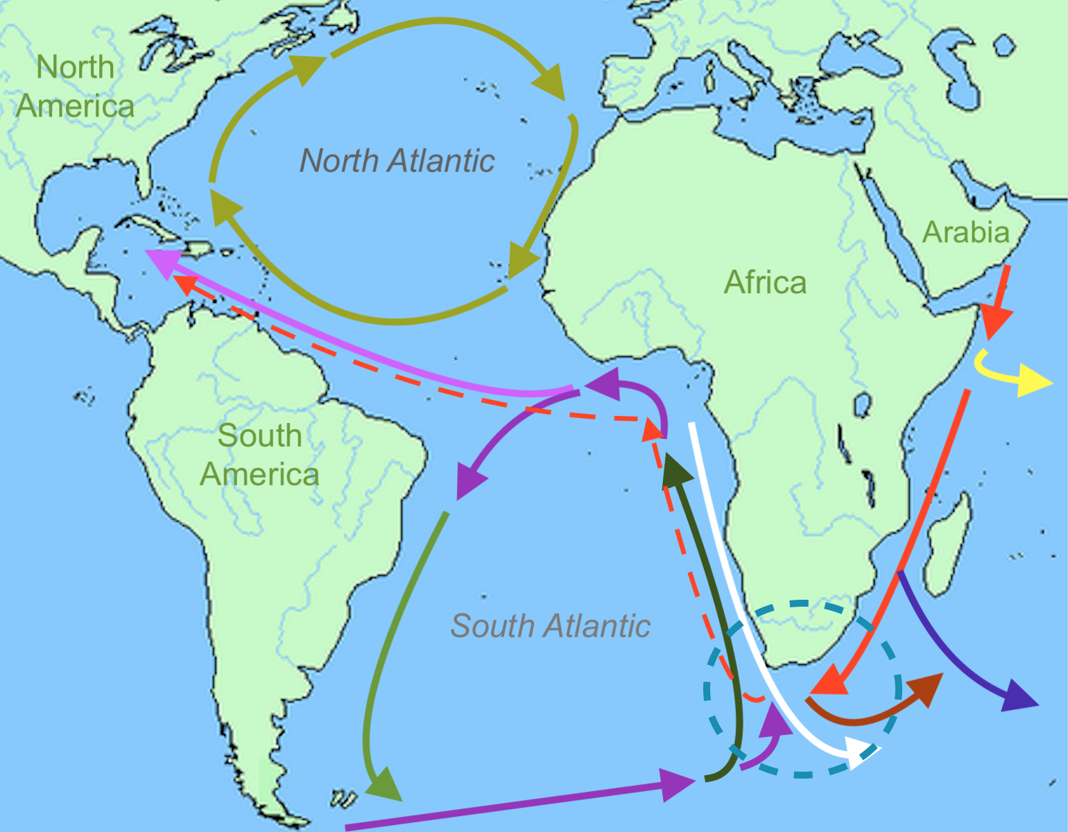
Arrows:
(Red) Proposed course; (Yellow) Somali Current; (Blue) South Indian Current;
(Brown) Agulhus Current driven backward; (White) weak Angola Current; (Dark
Green) Benguela Current; (Bottom Purple) South Atlantic Current; (Light Green)
Brazil Current; (Top Purple) South Equatorial Current; (Light Purple) Antilles
Current; (Olive Green) left-Gulf Stream; top-North Atlantic Drift; right-Canary
Current; bottom-North Equatorial Current
You have to love it when people of today approach sailing in ancient times with a cruise on some local river. Ocean travel was extremely dangerous even to the most experienced of sailors and officers. By way of example, in just the years 1800 to 1899, peace time losses of ships at sea numbered 103, of which 28 belonged to the United States, 59 were British, with the loss of life about 30,550. These were wooden sailing vessels from major countries involved in peacetime sailing.
Thus, once again what looks good on paper in the real world is really very different and in this case very dangerous for experienced sailors, telling us Lehi's crew would have been faced with an extremely hazardous voyage to attempt this course. In fact, this trip being described for Lehi around the Cape of Africa and into the Atlantic was, perhaps, one of the most difficult voyages that could have been undertaken in that time and under those conditions, especially with an inexperienced crew on their first ocean voyage.


No comments:
Post a Comment