
Continuing
with our being asked recently about the Sea East and the East Wilderness with our
response ending up being long enough for a full article and not simply a
comment answer. Previously, we discussed the land setup that Mormon outlined in
Alma 22:27, including the Land of Nephi, the Land of Zarahemla, and the Narrow
Strip of Wildeness along with the East and West Wildernesses.


And
at this time Moroni “cut off all the strongholds of the Lamanites in the east
wilderness, yea, and also on the west, fortifying the line between the Nephites
and the Lamanites. Thus we see:
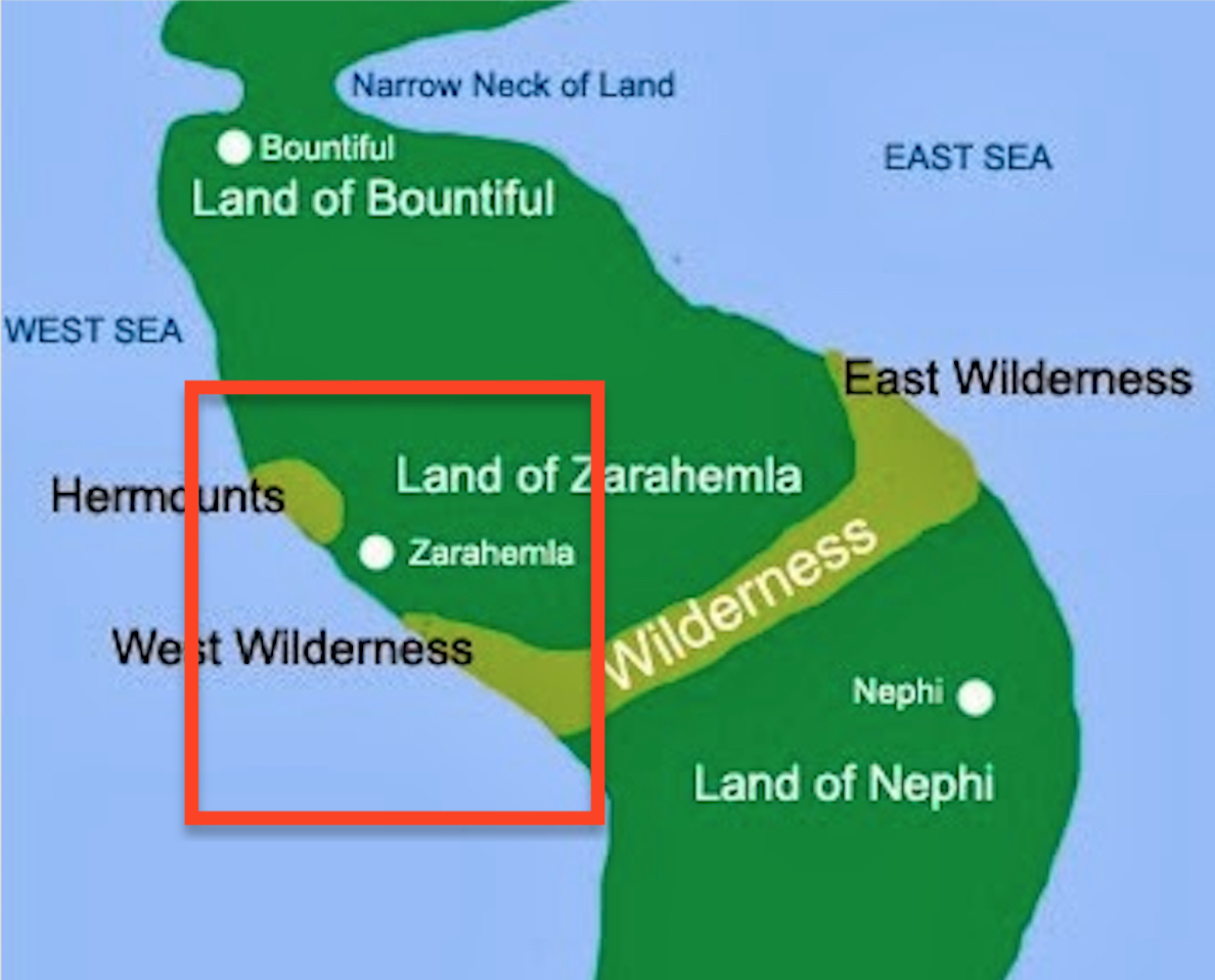
1. the narrow strip of wilderness which ran across the land from sea to sea and curved up (“round about”) along the seashore on the Sea East and the Sea West, encompasses both the wilderness on the east and the wilderness on the west;
2. These are the same wildernesses where the Lamanites lived in tents “the more idle part of the Lamanites lived in the wilderness, and dwelt in tents and they were spread through the wilderness on the est in the Land of Nephi, yea, and also oon the west of the land of Zarahemla, in the borders by the seashore…” (Alma 22:28), and also “And also there were many Lamanites on the east by the seashore, whither the Nephites had driven them” (Alma 22:29);

4. Continuing with Mormon “…from the east to the west, round about on the wilderness side; on the north, even until they came to the land which they called Bountiful” (Alma 22:29). Thus, the wildernesses involved are those shown in the maps above (not to scale) which Mormon tells us crossed between the land of Zarahemla and the Land of Nephi and curved up (“round about”) on both the east and west seashores and then ran northward for distances that caused these wildernesses to nearly surround the Nephites (see maps above).
5. Again Mormon writes: “nevertheless the Nephites had taken possession of all the northern parts of the land bordering on the wilderness, at the head of the river Sidon, from the east to the west, round about on the wilderness side; on the north, even until they came to the land which they called Bountiful” (Alma 22:29). Thus, even though the Lamanites were all across the land from sea to sea in the south, and occupied the east and west wildernesses where they curved upward from this south, or narrow strip of wilderness.
Now, from the point northward (beyond these two wilderness extensions), the Nephites controlled everything from sea to sea going northward until they reached the land of Bountiful—at that time in their existence, was as far northward as the Land of Promise extended as far as the Nephites knew.
[One of the problem in following Mormon is that readers today, who have already read past Mormon’s Alma, forget that they are dealing in time frames. Mormon, who writes in about 380 A.D. keeps his dialogue abridgement consistent with the time frame in which he is writing and in 90 to 77 B.C. (Alma 22), Mormon is comparing matters with how they were among the Nephites in that period—not 380 A.D.]
Continuing with Mormon: “And thus he cut off all the strongholds of the Lamanites in the east wilderness, yea, and also on the west, fortifying the line between the Nephites and the Lamanites, between the land of Zarahemla and the land of Nephi, from the west sea, running by the head of the river Sidon—the Nephites possessing all the land northward, yea, even all the land which was northward of the land Bountiful, according to their pleasure” (Alma 50:11).

Now after preparing the line in the
south (along the narrow strip of wilderness in the Land of Zarahemla), Moroni,
who did prepare strongholds against the coming of their enemies (Alma 50:6),
turned toward the now vacant East Wilderness after driving out the Lamanites
(Alma 50:7), and causing that Nephite families in the Land of Zarahemla and the
land round about should go forth into the east wilderness, even to the borders
by the seashore, and possess the land. This land was just north of the Lamanite
lands (Alma 50:7) and in which Moroni had the Nephites build a city which they
called Moroni (Alma 50:13).
Consequently, we see that the Land of Promise at this time had a definitive line or boundary between the Land of Nephi to the South and the Land of Zarahemla to the North, between which was the narrow strip of wilderness (South Wilderness). The East Wilderness was pretty much occupied from this time forward, though assuredly not all of it, as well as the land along the west seashore north of this wilderness line. We should also keep in mind, from this time forward, we know a great deal more about the Sea East and the land along the eastern seashore since that is where the Nephites built several cities after Moroni drove the Lamanites out of the East Wilderness. Also, partly because the City of Nephi was in the east near the Sea East, it was up this eastern corridor that the Lamanites continually attacked, all the way to within a short distance of the city of Bountiful.
 We know less about the Sea West and
western seashore corridor at this time forward since, no doubt, the Nephites
did not occupy that area as much, probably because it was mostly desert. The one
major exception to this is the area of Zarahemla in which not only the City of
Zarahemla, but all the adjacent cities and settlements connected to the
governmental capital of the Nephite Nation.
We know less about the Sea West and
western seashore corridor at this time forward since, no doubt, the Nephites
did not occupy that area as much, probably because it was mostly desert. The one
major exception to this is the area of Zarahemla in which not only the City of
Zarahemla, but all the adjacent cities and settlements connected to the
governmental capital of the Nephite Nation.
South of this area of Zarahemla, the line separating the Land of Zaraahemla from the Land of Nephi (the line or border or narrow strip of wilderness) was mostly unoccupied (South Wilderness) and it was later that Coriantumr arrived in Zarahemla coming up this mostly vacated coastal route with his surprise attack on the City of Zarahemla, and from which he launched his further northward penetration up the center of the land toward Bountiful before he was eventually stopped.
Thus, it is along the Sea East and eastern seashore that the majority of the final events of the Book of Mormon takes place, from Morianton’s battle with the people of the city of Lehi over a boundary dispute and his flight northward toward Bountiful and the narrow neck and narrow passage beyond the city of Bountiful, and Moroni sending Teancum northward to cut off Morianton and his people, to Amalikiah, the Nephite defector, then in charge of the Lamanite armies, fighting his way up this corridor and capturing several Nephite cities before he was finally driven out by Moroni’s stratagem.
(See the next post, “The Sea East and the East Wilderness – Part III,” for a further discussion of these wildernesses and seas that Mormon describes)

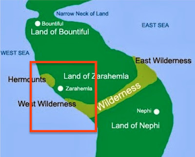
Mormon describes this land layout in
Alma ch 22
In
addition, Mormon tells us that Capt. Moroni placed armies on the south, in the
borders of their possessions, and caused them to erect fortifications that they
might secure their armies and their people from the hands of their enemies”
(Alma 50:10). This south area “in the
borders of their possessions” is the exact same area Mormon outlined in
Alma 22:27 along the area of the narrow strip of wilderness, which was the
southern border of the Land of Zarahemla.

" Moroni also fortified the line between the Nephites and the Lamanites, between the Land of Zarahemla and the Land of Nephi from the west sea, running by the head of the river Sidon--the Nephites possessing all the land northward, yea, even all the land which was northward of the land Bountifujl, according to their pleasure" (Alma 50:11)
1. the narrow strip of wilderness which ran across the land from sea to sea and curved up (“round about”) along the seashore on the Sea East and the Sea West, encompasses both the wilderness on the east and the wilderness on the west;
2. These are the same wildernesses where the Lamanites lived in tents “the more idle part of the Lamanites lived in the wilderness, and dwelt in tents and they were spread through the wilderness on the est in the Land of Nephi, yea, and also oon the west of the land of Zarahemla, in the borders by the seashore…” (Alma 22:28), and also “And also there were many Lamanites on the east by the seashore, whither the Nephites had driven them” (Alma 22:29);
3.
Now this is the south wilderness, identified to us as the narrow strip of wilderness that
curved upward along both seashores (“round about”). Of this wilderness, Mormon
tells us: “And thus the Nephites were nearly surrounded by the
Lamanites; nevertheless the Nephites had taken possession of all the northern
parts of the land bordering on the wilderness, at the head of the river Sidon…”

This South Wilderness IS the narrow strip of wilderness, both are in the south and there would only be one named South Wilderness. If there were two, south wildernesses the other would have a name, not an adjective for a label
Again, this wilderness is the narrow
strip of wilderness separating the Land of Zarahemla from the Land of Nephi, in
which we showed earlier that Mormon placed the beginning or the “head” meaning
“source” of the River Sidon.4. Continuing with Mormon “…from the east to the west, round about on the wilderness side; on the north, even until they came to the land which they called Bountiful” (Alma 22:29). Thus, the wildernesses involved are those shown in the maps above (not to scale) which Mormon tells us crossed between the land of Zarahemla and the Land of Nephi and curved up (“round about”) on both the east and west seashores and then ran northward for distances that caused these wildernesses to nearly surround the Nephites (see maps above).
5. Again Mormon writes: “nevertheless the Nephites had taken possession of all the northern parts of the land bordering on the wilderness, at the head of the river Sidon, from the east to the west, round about on the wilderness side; on the north, even until they came to the land which they called Bountiful” (Alma 22:29). Thus, even though the Lamanites were all across the land from sea to sea in the south, and occupied the east and west wildernesses where they curved upward from this south, or narrow strip of wilderness.
Now, from the point northward (beyond these two wilderness extensions), the Nephites controlled everything from sea to sea going northward until they reached the land of Bountiful—at that time in their existence, was as far northward as the Land of Promise extended as far as the Nephites knew.
[One of the problem in following Mormon is that readers today, who have already read past Mormon’s Alma, forget that they are dealing in time frames. Mormon, who writes in about 380 A.D. keeps his dialogue abridgement consistent with the time frame in which he is writing and in 90 to 77 B.C. (Alma 22), Mormon is comparing matters with how they were among the Nephites in that period—not 380 A.D.]
Continuing with Mormon: “And thus he cut off all the strongholds of the Lamanites in the east wilderness, yea, and also on the west, fortifying the line between the Nephites and the Lamanites, between the land of Zarahemla and the land of Nephi, from the west sea, running by the head of the river Sidon—the Nephites possessing all the land northward, yea, even all the land which was northward of the land Bountiful, according to their pleasure” (Alma 50:11).

This is the area which included the East Wilderness (not to scale) in
which Moronidrove out the idle Lamanites living in tents and brought in
Nephites from the Land of Zarahemla to build cities—those cities were mostly
built in the southern area and northward along the coast
Consequently, we see that the Land of Promise at this time had a definitive line or boundary between the Land of Nephi to the South and the Land of Zarahemla to the North, between which was the narrow strip of wilderness (South Wilderness). The East Wilderness was pretty much occupied from this time forward, though assuredly not all of it, as well as the land along the west seashore north of this wilderness line. We should also keep in mind, from this time forward, we know a great deal more about the Sea East and the land along the eastern seashore since that is where the Nephites built several cities after Moroni drove the Lamanites out of the East Wilderness. Also, partly because the City of Nephi was in the east near the Sea East, it was up this eastern corridor that the Lamanites continually attacked, all the way to within a short distance of the city of Bountiful.
South of this area of Zarahemla, the line separating the Land of Zaraahemla from the Land of Nephi (the line or border or narrow strip of wilderness) was mostly unoccupied (South Wilderness) and it was later that Coriantumr arrived in Zarahemla coming up this mostly vacated coastal route with his surprise attack on the City of Zarahemla, and from which he launched his further northward penetration up the center of the land toward Bountiful before he was eventually stopped.
Thus, it is along the Sea East and eastern seashore that the majority of the final events of the Book of Mormon takes place, from Morianton’s battle with the people of the city of Lehi over a boundary dispute and his flight northward toward Bountiful and the narrow neck and narrow passage beyond the city of Bountiful, and Moroni sending Teancum northward to cut off Morianton and his people, to Amalikiah, the Nephite defector, then in charge of the Lamanite armies, fighting his way up this corridor and capturing several Nephite cities before he was finally driven out by Moroni’s stratagem.
(See the next post, “The Sea East and the East Wilderness – Part III,” for a further discussion of these wildernesses and seas that Mormon describes)


No comments:
Post a Comment