
We
were asked recently about the Sea East and in the response, it ended up being
long enough for a full article and not simply a comment answer.
Comment: “I understand the city of Nephihah was not along the east coast but inland, yet it was evidently built around the time of the city of Moroni which was one of those cities built by those Nephites that Capt. Moroni caused to move into the East Wilderness to occupy the land from which he had driven out the Lamanites who had lived in tents in that east wilderness” Charles G.M.

From previous side discussions, I know that some of our readers feel this is where Sidon is and its “head” or source, and not in the narrow strip of wilderness where Mormon apparently placed it.
The problem with that is it would place the East wilderness north of the narrow strip of wilderness and due north of this south wilderness and create two separate wilderness areas of which Mormon does not specifically speak. On the other hand, when we look at the wilderness in Alma 22 and what is being discussed at this point, we see a different picture of an East Wilderness which Mormon addresses early on in his overall description of the lands. In following his outline of Alma 22, we find a different and more accurate picture of the layout of the land.
First of all, when we start placing seas or wildernesses, which are named by cardinal compass points, (South Wilderness, East Sea,etc.) we have to keep in mind those names were given under both Hebrew and Nephite habit of naming something a direction in relationship to its actual direction from the land overall. As an example, they would not name a wilderness in the middle of their land an east or west wilderness since it is not to the east or west of the land overall, but in the center. Ancients did not name places like that, and neither did the Hebrews.


Many years ago when I was working for a large office as an architect, designing office buildings for a major corporation, I was asked if I could explain to their corporate officers how the unusual addressing system in Salt Lake City worked.
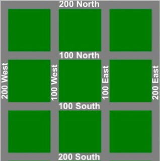 For
those outside Utah, the unusual Mormon way of using addresses is quite simple,
there is a center place in a town or community or city, usually with the intersections
of Main and Temple (or Center), i.e., 100 East/West and 100 North/South. The area is then
laid out in blocks of 100 each labels, i.e., 100 N., 200 N., 300 N., etc. So
you combine two addresses, either north and east, or north and west, or south
and west, or south and east, i.e., 2453 N., 1300 W, which means 24 blocks to
the north and 13 blocks to the west, with the actual address of 2453 on the
house (which would be about in the middle of the block).
For
those outside Utah, the unusual Mormon way of using addresses is quite simple,
there is a center place in a town or community or city, usually with the intersections
of Main and Temple (or Center), i.e., 100 East/West and 100 North/South. The area is then
laid out in blocks of 100 each labels, i.e., 100 N., 200 N., 300 N., etc. So
you combine two addresses, either north and east, or north and west, or south
and west, or south and east, i.e., 2453 N., 1300 W, which means 24 blocks to
the north and 13 blocks to the west, with the actual address of 2453 on the
house (which would be about in the middle of the block).
The point is, to those outside of Utah or other Mormon street name locals, you might have an address of 2453 N. Marigold Ave., but unless you know where Marigold Ave., is located, you have no idea what part of the city the house or building is in. With the LDS numbering area, you know it is in the one of four quadrants, and since all numbers are sequential, you can generally find the address without any assistance.
In this way, the ancients gave numbering and directional names to locations and they were not confusing or out of order, but very chronological and orderly in sequence. To place an East Wilderness that is not obviously in the East would make no sense, and to call two separated areas of wilderness in the south a “South Wilderness” would not have been how their system worked. To us today, who use names and directions rather randomly, we might not think that way, but the Hebrews did and the Nephites would have as well, placed direction names at the edges or near the far edges of the land in which they were discussing--or at least the place being the furthese in that direction.
Thus, when Mormon gives us an understanding of this Narrow Strip of Wilderness, he makes it clear that the Lamanite king’s land, the Land of Nephi, “was divided from the land of Zarahemla by a narrow strip of wilderness, which ran from the sea east even to the sea west, and round about on the borders of the seashore, and the borders of the wilderness which was on the north by the land of Zarahemla, through the borders of Manti, by the head of the river Sidon, running from the east towards the west -- and thus were the Lamanites and the Nephites divided” (Alma 22:27).

Continuing with the rest of Mormon’s description: “was divided from the land of Zarahemla by a narrow strip of wilderness, which ran from the sea east even to the sea west, and round about on the borders of the seashore, and the borders of the wilderness which was on the north by the land of Zarahemla, through the borders of Manti, by the head of the river Sidon, running from the east towards the west—and thus were the Lamanites and the Nephites divided” (Alma 22:27).
So the narrow strip of wilderness was on the north by the Land of Zarahemla, through the borders of Manti—that is, the strip of wilderness ran through the borders of Manti (i.e., from east to west) by the head of the river Sidon. That is, the narrow strip running from the West Sea to the East Sea ran through the east and west borders of Manti, which was situated in the hills or mountains to the south of the Land of Zarahemla and at a higher elevation than Zarahemla, along by, or within, the narrow strip of wilderness. In addition, within this narrow strip of wilderness, or very close to it (“by”) was the beginning, the “head” or source of the River Sidon, high up in the hills or mountains, than ran down past Manti into the valley or Land of Zarahemla.
(See the next post, “The Sea East and the East Wilderness – Part II,” for a further discussion of these wildernesses and seas that Mormon describes)
Comment: “I understand the city of Nephihah was not along the east coast but inland, yet it was evidently built around the time of the city of Moroni which was one of those cities built by those Nephites that Capt. Moroni caused to move into the East Wilderness to occupy the land from which he had driven out the Lamanites who had lived in tents in that east wilderness” Charles G.M.

Lamanites leaving the East Wilderness and heading south back into their own lands which Land of Nephi bordered this east wilderness along the south
Response:
There is considerable controversy among various theorists about the Sea East
and the East Wilderness in this region. Some place the wilderness so far inland
it would actually be in the middle of the land of Zarahemla and from there make
the leap to Lake Junin, north of the City of Zarahemla, to be the source of the
River Sidon; however, that would place the Sidon north of where Mormon places
it in Alma 22:28, and flowing south through the Land of Zarahemla against
Mormon’s description.From previous side discussions, I know that some of our readers feel this is where Sidon is and its “head” or source, and not in the narrow strip of wilderness where Mormon apparently placed it.
The problem with that is it would place the East wilderness north of the narrow strip of wilderness and due north of this south wilderness and create two separate wilderness areas of which Mormon does not specifically speak. On the other hand, when we look at the wilderness in Alma 22 and what is being discussed at this point, we see a different picture of an East Wilderness which Mormon addresses early on in his overall description of the lands. In following his outline of Alma 22, we find a different and more accurate picture of the layout of the land.
First of all, when we start placing seas or wildernesses, which are named by cardinal compass points, (South Wilderness, East Sea,etc.) we have to keep in mind those names were given under both Hebrew and Nephite habit of naming something a direction in relationship to its actual direction from the land overall. As an example, they would not name a wilderness in the middle of their land an east or west wilderness since it is not to the east or west of the land overall, but in the center. Ancients did not name places like that, and neither did the Hebrews.

Under the ancients’ way of labeling
directions for places, “East” meant the furthest east of something, there were
no large extensions of that land between two “East” places
If
we then include a “South Wilderness” as mentioned in Alma 16:6, it would appear
that we have both a “South Wilderness” and a “Narrow Strip of Wilderness’ in the
south, between the Land of Zarahemla” and the “Land of Nephi” (Alma 22:27),
which would give us a land layout that looked like this:
Such a layout and naming use of
cardinal points would not have made any sense to the ancients—Therefore, there
would not be under this system a South Wilderness south of an East Wilderness,
when at some points along the south wilderness (or line) the East Wilderness
would actually be to the West
Thus,
when looking at the use of North, East, South and West, in the Book of Mormon,
we need to understand the Hebrew and the ancients’ way of both thinking and
speaking as they used labels to indicate areas, much like we use names.Many years ago when I was working for a large office as an architect, designing office buildings for a major corporation, I was asked if I could explain to their corporate officers how the unusual addressing system in Salt Lake City worked.

The point is, to those outside of Utah or other Mormon street name locals, you might have an address of 2453 N. Marigold Ave., but unless you know where Marigold Ave., is located, you have no idea what part of the city the house or building is in. With the LDS numbering area, you know it is in the one of four quadrants, and since all numbers are sequential, you can generally find the address without any assistance.
In this way, the ancients gave numbering and directional names to locations and they were not confusing or out of order, but very chronological and orderly in sequence. To place an East Wilderness that is not obviously in the East would make no sense, and to call two separated areas of wilderness in the south a “South Wilderness” would not have been how their system worked. To us today, who use names and directions rather randomly, we might not think that way, but the Hebrews did and the Nephites would have as well, placed direction names at the edges or near the far edges of the land in which they were discussing--or at least the place being the furthese in that direction.
Thus, when Mormon gives us an understanding of this Narrow Strip of Wilderness, he makes it clear that the Lamanite king’s land, the Land of Nephi, “was divided from the land of Zarahemla by a narrow strip of wilderness, which ran from the sea east even to the sea west, and round about on the borders of the seashore, and the borders of the wilderness which was on the north by the land of Zarahemla, through the borders of Manti, by the head of the river Sidon, running from the east towards the west -- and thus were the Lamanites and the Nephites divided” (Alma 22:27).

The narrow strip of wilderness ran from sea to sea, and at the
seashore, “round about on the borders” or curving to run along the seashore.
Thus at the moment, the curving extensions of the wilderness in both the east
and west curved upward along the seashore encompassing the Nephites in a
partial enclosure or, as Mormon stated it: “nearly surrounded by the Lamanites”
(Alma 22:29)--It should be noted that under the Hebrew (or Nephite) system, there would not be two East Wildernesses any more than two east seas--if there were two East Wildernesses, then one of them would have a name, such as the West Wilderness and the Wilderness of Hermonts, or the Sea North and the Waters of Ripliancom
Now the term “round about,”
pronounced “rounda bout,” in 1828 is defined as “round” meaning cylindrical; circular;
spherical or globular; and “about” means in a circular course, to wind in a
circle, circularly about.” In other words, not a straight line, i.e, a course
that curves, bends, or moves about. So “round about on the borders of the
seashore” means a line running its course across the land and curving up (or down) along
the seashore. Today, the meaning of “round about” is basically the same: “not
following a short direct route, circuitous, indirect, meandering, serpentine.”Continuing with the rest of Mormon’s description: “was divided from the land of Zarahemla by a narrow strip of wilderness, which ran from the sea east even to the sea west, and round about on the borders of the seashore, and the borders of the wilderness which was on the north by the land of Zarahemla, through the borders of Manti, by the head of the river Sidon, running from the east towards the west—and thus were the Lamanites and the Nephites divided” (Alma 22:27).
So the narrow strip of wilderness was on the north by the Land of Zarahemla, through the borders of Manti—that is, the strip of wilderness ran through the borders of Manti (i.e., from east to west) by the head of the river Sidon. That is, the narrow strip running from the West Sea to the East Sea ran through the east and west borders of Manti, which was situated in the hills or mountains to the south of the Land of Zarahemla and at a higher elevation than Zarahemla, along by, or within, the narrow strip of wilderness. In addition, within this narrow strip of wilderness, or very close to it (“by”) was the beginning, the “head” or source of the River Sidon, high up in the hills or mountains, than ran down past Manti into the valley or Land of Zarahemla.
(See the next post, “The Sea East and the East Wilderness – Part II,” for a further discussion of these wildernesses and seas that Mormon describes)


I often wonder what Jonathan Neville's interest in the BOM geography really is. The maps are so inaccurate that anybody with any understanding of BOM geography should be able to see the problems. I guess I don't get it. A simple check of a few verses in the BOM and using some simple logic is enough to show inaccuracies. You would think that he would have figured out long ago that his model is complete fiction.
ReplyDeleteVery well said. I feel certain we will go down to our graves without an answer of any consequence.
ReplyDelete