
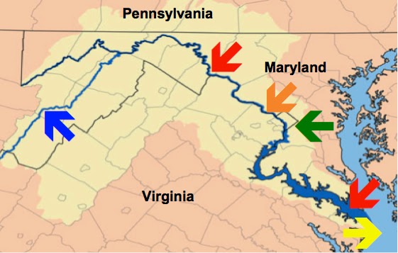
Another large eastern river is the Potomac, whose mouth also empties into the Chesapeake Bay. The Potomac is the 4th largest river along the Atlantic coast, is 405 miles long (including the main stem and North Branch), and beyond Washington D.C. is quite shallow. From the mouth of the Potomac River, where it empties into the Chesapeake Bay to Hains Point in southwest Washington D.C. (near the Jefferson Memorial), a distance of about 103 miles, the river is 48 feet deep, but from there further upriver, the depth drops dramatically.
As an example, the normal water level at Little Falls, just upriver from Washington is 2.9 feet; it is 0.7 feet at Point of Rocks, 1.7 feet at Shepherdstown, 2.5 feet at Hancock, and 3.0 feet at Paw Paw. In addition, from Bear Island to Olmsted Island the river is strewn with large and small islands and narrow channels that are extremely shallow and full of rocks, creating several falls, or rapids, where only canoes and kayaks can negotiate. In fact, the Maryland Department of Natural Resources issues bulletins when it is not even safe on the river in a kayak except for very experienced individuals and teams.

From the Atlantic Ocean into Chesapeake Bay, which has an average depth of 21 feet (200 feet in some isolated areas, though a 6’ tall person could wade through more than 700,000 acres of the Bay and never get their hat wet), to Washington D.C., deep-sea sailing ships and ocean-going vessels have always been able to navigate. However, because of numerous rapids, falls and shallow depths, the Potomac above Washington has always been unnavigable.
As an example, according to National Weather Service, the Potomac at Harper’s Ferry and the confluence with the Shenandoah River, 62 miles upriver from Washington D.C., is only four feet in depth; only 18 miles upriver from Washington is the area known as The Great Falls of the Potomac River, an unnavigable area that blocked all types of shipping beyond that point.

In 1785, George Washington had the "Patowmack Canal" started that eventually connected the Tidewater region near Georgetown with Cumberland, Maryland. Finished in 1802, the canal allowed freight to be transported by shipping around the rapids for the first time. Obviously, there is no possibility that Lehi sailed up the Potomac in Nephi’s ship that crossed the Great Deep. For those who claim Lehi went up any of the eastern inland waterways is simply a fallacious or ignorant argument since all these waterways in the east that might point toward the Great Lakes area are shallow and rarely are navigable beyond a hundred miles inland, leaving Lehi having to travel several hundred miles overland to the area that the Great Lakes Theorists claim is the Land of Promise--which is not supported by the scriptural record.

In addition, many of these inland water ways, part of the river commerce system of the United States, have been man-made, i.e., canals, channels, and waterways that have been dug, such as the Erie Canal; connected, such as the canal connecting the Ohio to Lake Michigan; extended, such as the Atlantic Intracoastal Waterway from Key West Florida, to Norfolk, Virginia; dredged, such as the Mississippi, Ohio, and others, in order to allow commerce and travel today. Many have locks, which raise the water level to accommodate shipping, such as the Ohio, Upper Mississippi, Illinois and Tennessee rivers.
Many others are only deep enough for barges that haul freight, but not an ocean going vessel that requires depth for its deeper hull. As an example, barges are an extremely efficient mode of transportation, moving about 22,500 tons of cargo as a single unit. A single 15-barge tow is equivalent to about 225 railroad cars or 870 tractor-trailer trucks. If the cargo transported on the inland waterways each year had to be moved by another mode, it would take an additional 6.3 million rail cars or 25.2 million trucks to carry the load. So the waterways have been dug, extended, formed or altered to make them navigable, beginning in the 1800s.

Obviously, this inland waterway which modern man accepts without thought, did not exist in its present configuration and length in 600 B.C., or even before the 19th-century.
What is often not understood is that historical events did not always happen the way we think or according to our interpretation of the facts. As an example, as has been reported here many times, the early trade routes from India to and through Indonesia to China, etc., which Sorenson and others have used to claim Lehi sailed through Indonesia to the Pacific in the same manner, did not take place in deep sea, ocean-going ships, but in shallow-bottomed, weak-hulled coastal boats that sailed close to shore and were put in at night, for storms, or in bad weather since their vessels were not strong enough to handle the constant pounding of the deep sea, strong waves and the pressure of much canvas on masts (despite what is shown in Hollywood movies). As an example, the basically calm waters of the Mediterranean Sea upon which the Egyptians, Greeks, Romans, and Phoenicians sailed, is far different from the heavy pounding sea upon which the later explorers of the 15th century onward sailed. One cannot judge the one example with the other--that is like comparing apples and grapes.
In addition, what is not seen on a map that appears to provide a course from one point to another, is the obstructions that hinder passage or block it all together along rivers and waterways, making it impossible to sail where the finger on a map can go. And finally, ships of today can go places and handle difficulties that no ship of the past could have done—in 600 B.C., there were no compasses, maps, GPS, radar, sonar, radio, etc. When Lehi set sail, he was on his own across thousands of miles of ocean. He went where the wind blew him and the ocean currents took him, and sailing up any river under such circumstances would be highly unlikely when you consider that the currents flow downriver and the winds along rivers are fickle at best because of the surrounding terrain.

The point is, as has been shown in these past three posts, the inland waterway system of the Eastern United States would simply not be a viable method of getting Nephi’s ship from the ocean to an inland area, such as the Great Lakes. It has to be kept in mind that a theory that looks good on paper (map in this case) is not necessarily workable in the real world.


Thank you for posting such a great blog. I found your website perfect for my needs. Read About Atlantic intracoastal waterway
ReplyDelete