skip to main |
skip to sidebar
Continuing
with the Great Lakes and Heartland theories that have Lehi sailing up a river
from the Atlantic Ocean or Gulf of Mexico to reach the theorists’ Land of
Promise, this third part concludes the series. Part I, covering the St.
Lawrence approach from the northeast out of the Atlantic, and Part II, which
was about the Mississippi River approach (especially entering the Delta and
trying to sail a deep sea vessel up river), were covered in the previous two
posts. Both posts showed how impossible it would have been in 600 B.C., as it
was for 2400 years afterward before channels were dug around rapids or the
deepening of the main river to a nine-foot depth maintained between Baton Rouge (135 miles upriver from New Orleans) and Minneapolis, Minnesota.
In
this third and final post we will show the importance of knowing and
understanding the conditions of the eastern rivers and the difference between
sailing a flat-bottomed river boat and a deep-sea ocean sailing vessel up a
river.
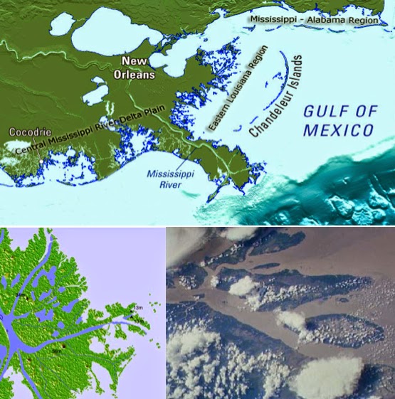
Looking downriver on the Mississippi
through New Orleans. On the inside bend is (Yellow Arrow) Algiers Point, 114
miles upriver from the Gulf, and across the river on the outside of the bend,
(White Arrow) is the Governor Nicholls Street Wharf. The river flows (Green
Arrow) toward the Gulf
The
2350-mile-long river is at its deepest point of 200 feet between Algiers Point
(on its right descending bank) and Governor Nicholls Street Wharf (on its left
descending bank), including the French Quarter, The Marigny (Faubourg Marigny)
and Bywater (where Mardi Gras begins), an overall area referred to as “Sliver
by the River,” after Hurricane Katrina because of its higher elevation. From
this point upriver to Baton Rouge, a depth of 45 feet is maintained today, but
beyond that point a system of 29 locks and dams are required to maintain a 9-foot
depth, and at its headwaters outlet of Lake Itasca, Minnesota, it is just 3
feet deep.
To
maintain these Federally mandated depths—45 feet between New Orleans and Baton
Rouge, and nine feet from there to Minneapolis, the Corps of Engineers
continually dredges the river. Before their involvement, only flat-bottomed
River Boats could negotiate north of Baton Route because of their shallow draft
and ease of both running aground (without damage) and becoming disentangled from sandbars and
other shallow depths.
To
understand sailing up the Mississippi, even if there was keel depth to do so
(which there was not), is based strictly upon wind and current—and the
Mississippi, as is the case with all of that watershed, flows south, downriver! Thus, we need to understand
the speed and strength of the water flow of the Mississippi River Nephi's ship would have had to overcome.
Left: Bend of the Mississippi past Algiers Point. Yellow Arrow: Direction of the Bright Field Cargo Vessel; Red Arrow: Governor Nicholls Street Wharf--point of impact; Green Arrow: Flow direction of the Mississippi moving downriver to the Gulf. Right: The Bright Field after impact with the wharf. Several Tugs are needed to keep the ship from drifting down river with the strong current
According
to the U.S. Coast Guard Investigation and Report, the fully loaded downbound Chinese
bulk cargo ship, Bright Field, under
the command of Master Deng Jing Kuan, after losing propulsion power and unable
to effectively steer, swung slowly to port and eventually allided (ship
colliding with stationary objects) with the Riverwalk Marketplace complex near
downtown New Orleans just above Algiers Point in 1996. Operated by Cosco out of
Hong Kong, the eight-year-old Japanese-built ship rammed a pier, condominium,
shops and hotel along the docks, causing some 17-million dollars of damage and
sixty-six injuries.
This
tragedy points out the importance of being able to steer when moving up and
down a river like the Mississippi, especially in light of its treacherous
currents and twisting bends. In fact, the Mississippi River around New Orleans
is said to be the most difficult waterway to navigate in the world.
Add
to this that the Mississippi in this area generally flows about 4.5 mph toward
the Gulf, which is 268,525.584 gallons of water per minute past Algiers Point, which
was one of the major factors, outside of equipment failure, that the Bright Field slammed into the docks in
New Orleans. In fact, it was the flow of the current that increased the cargo
ship to a speed beyond the ship’s rated Sea Speed.
In addition, because of the high rate of flow during high water periods, today the
Corps of Engineers opens the Bonnet Carré Spillway (built in 1932, 33 miles
above Algiers Point), which diverts ¼-million cubic feet of water per second.
This lowers the river by 4 feet and reduces its flow to combat strong river
currents for engine-powered vessels. If such is needed to aid powerful engines
to drive a vessel upriver through and past New Orleans, think of Nephi’s ship
in 600 B.C.—there was no such assistance possible—the Mississippi River flowed at
its original velocity.
The Mississippi River watershed is
the fourth largest in the world, extending from the Allegheny Mountains in the
east to the Rocky Mountains in the west, and measures about 1.2 million square
miles, covering about 40% of the lower 48 states—and all rivers in it flow
toward the Gulf of Mexico, or downriver, heavily affecting a sailing ship
“driven forth before the wind” trying to sail upriver
Considering
at maximum speed, Columbus’ Santa Maria could travel about 8.5 knots. Now the speed
of a ship is based on its ground speed, i.e., the ship’s speed plus the speed
of the following current (flowing in the direction the ship is headed). So if
the current is 4.5 knots (5.2 mph), Columbus vessel could travel about 15 mph.
However, when sailing against the
same current, his speed would drop to 9.8 mph. And if he was sailing against
the wind, then he would have no forward progress at all. In fact, he would be
driven backward at the speed of 15 mph (unless he took down his sails, then he
would be driven back at 5.2 mph). This
is because a 15th century sailing vessel’s propulsion was strictly
wind and current—just like that of Nephi’s ship.
When
you consider all these factors and apply the speed of the current against
Nephi’s ship, the shallowness of the Mississippi beyond Baton Rouge (nine feet because the Corps of Engineers continually dredges the river), the wind
that usually blows toward the southwest (downriver), and the experience needed
to even sail their ship up the Mississippi, let alone negotiate all the
crossing eddies, sudden shifts in current, shallow sand bars, etc., it is
simply foolishness to suggest that Lehi went up the Mississippi at all.
And
for those who might claim that we don’t know what the Mississippi was like in
600 B.C., roughly 2600 years ago, they might want to realize that scientists
who have studied the Mississippi for many years (it is perhaps the most studied
river in the world), tell us that the Mississippi has not changed much in the
past 10,000 years. Its course has changed from time to time, and
certainly other rivers eventually flowed in and out of it, but its basic
properties: flow, direction, depth, and the winds that pass over it, have not
changed in the past 10,000 years, though man has made its entrance far safer and more reliable for navigation, according to Clint Willson, LSU professor of civil and environmental engineering and director of the Vincent A. Forte River and Coastal Hydraulics Lab, and an expert in Mississippi River hydraulics and sediment transfer. While the river mouth used to swing back and forth across the eastern half of the Louisiana coast, today it is "a highly engineered massive river system lined with levees and other control structures."
There
is simply no way possible that Lehi could have sailed up the Mississippi River,
nor as stated in the first of these three posts, sailed up the St. Lawrence
River, to reach the area of the Great Lakes.
Continuing
with the Great Lakes and Heartland theories that have Lehi sailing up a river
from the Atlantic Ocean or Gulf of Mexico to reach the theorists’ Land of
Promise, we covered the St. Lawrence approach from the northeast out of the
Atlantic in the last post, and showed how impossible that was in 600 B.C., as it was for 2400
years afterward before the channels were dug around the rapids near Montreal. In
this post we will show the approach from the south, up the Mississippi River.
One
of the troubles we have today in understanding all this is every boat, ship,
schooner and yacht is equipped with powerful engines. Even “sailing boats” have
engines. For the past many years, only the most experienced blue water sailor might
think to go to sea without a backup engine.
Top Left: 26’ LWL Catalina 315 sailing boat has a 21 hp 3-cylinder diesel;
Top Right: 36’ Gulfstar has a diesel inboard engine; Bottom: 48’ Elan 494
Impression has a 75 hp engine
With
an engine, of course, a boat small or large, can make turns, sharply maneuver,
and work their way through narrows and around obstacles with comparative ease.
However, there were no engines in Lehi’s day. There was no knowledge of tacking,
booms, or hauling close to the wind. Boats had a fixed sail and you went where
the wind blew it. Even today, sailboats cannot sail dead on end (directly into
the wind), nor on a course that is too close to the direction from which the
wind is blowing (“no-go-zone”), but in Lehi’s time, boats were not designed and
sailors knew nothing of chock-a-block, or beating, or working to windward
(sailing toward the wind just off the “no-go-zone”), that is, sailing “upwind.”
Even when tacking was learned in the 16th century, it wasted a lot
of time to sail in that manner and seldom done, especially on long voyages, and
obviously a thorough knowledge of the winds had to be known and understood to
use them in such a manner to reach a destination.
Lehi’s
ship, and ships into the 15th century “ran downwind,” that is with
the wind coming directly behind the ship. This is called “running with the wind”
today, and what Nephi called being “driven forth before the wind” (1 Nephi
18:8, 9). The other term is “going with the flow,” that is, to move with the
flow of the current, which gave rise to the construction of ships with high
sterns (poop deck) to keep from being swamped from high following seas when
traveling in the current with the wind behind.
Consequently,
when a boat or ship entered the water in that ancient era, it automatically
became “adrift,” meaning it was at the will of the wind and tide. This is why
knowledge of winds and ocean currents became so important to sailing, and
continued even into and past the Age of Sail. It is an issue that even today, “landsman”
and “lubber” often fail to take into consideration when discussing sailing
routes of the past. As much as half of the comments about ancient sailing on
the internet today are made by those who know little or nothing about the
period and the difficulties or challenges early seamen faced.
From the first sails, seamen took
their ships where the wind blew them. These early routes across the oceans
determined early development, exploration, trade and conquest
Under
such conditions, any approach to the Mississippi Delta in 600 B.C., would have
been a hazardous experience for a sailing vessel “driven forth before the
wind.” Whenever rivers meet the ocean, soil and dirt carried by the river are
deposited at the mouth and new lands, shoals, and sand bars are created, forming
a delta. As these rivers enter the ocean, they tend to get off course and
branch into many directions, creating many small islands in the delta region.
This is particularly true with the Mississippi Delta.
Top: Map of the Mississippi Delta
today, with numerous channels and sub-entrances; Bottom Left: Satellite
imagery of Bird's Foot Delta, green being built up land, dark blue being river waterways to the
(light blue) Gulf; Bottom Right: Satellite view of created islands blocking the
entrances in the delta
Even
as late as the 18th century, just entering the Mississippi Delta was dangerous and in
1718, the French had Bar Pilots who boarded all ships entering the Delta to
help guide them through the dangerous eddies, channels, branches, and
ever-changing sandbars. The French built a Pilot station called the Belize, meaning “beacon,” and built
towers to mark the entrance.
When Louisiana was ceded to
Spain by secret treaty in 1762, the Spanish built a station in the same general
location and called it Balise, which was also a fortress to protect Louisiana
from pirates and the enemies of France. The Spanish Pilots and their deputies
were required to take frequent soundings of the bar with lead lines to
determine where the deepest parts of the channel were. These Pilots were
independent entrepreneurs and competition among them was fierce and often
violent. The ones with the fastest boats reached the incoming ships first and got
the job to pilot them in.
1744 French map of the Mississippi Delta East Pass, showing (yellow
arrow) Fort de la Balize (“seamark”) on the lower right
After 1800, because of the
Spanish Pilot concession abuses, pilots from Massachusetts, Maine, Nova Scotia,
England and Scandinavia joined forces and sailed on Pilot cutters cruising the
coast looking for sails on the horizon, and in 1805, the Pilot Act was passed,
seeking to regulate the appointment of these Pilots who, within a few years,
were called Branch Pilots because they piloted the branches of the Mississippi
river delta. By 1853, Balize was called Pilotsville, and the town moved about
five miles northwest on the west bank in the Southwest Pass channel, but in
1860, after succumbing to storm winds, the village was moved five miles upriver
on the east bank, just above the Head of the Passes, where the main stem of the
Mississippi branches off into three distinct directions at its mouth in the
area called “Bird’s Foot Delta.” By 1879 there were 38 bar and branch Pilots,
and no ship captain, concerned with the safety of his ship and crew, would dare
to attempt entering the delta without one aboard.

Nor would anyone sail up the
Mississippi, even in a steamboat, without knowing by heart the location of
every snag, rock, sandbar, and landmarks, as well as the depth of the water,
and strength of the current. Every Mississippi Pilot knew the meaning of differing colors
of the water, of the ripples and swirls, in order to deduce new
information about what lay ahead on the river, especially just below the
surface. They learned from experience for the river was a strict, dangerously fickle
teacher, that changed frequently.
To think that a deep sea vessel,
like Nephi’s ship that had crossed the ocean, with its deep “V” or rounded
keel, could have sailed up the Mississippi in 600 B.C. with an inexperienced
crew with almost no experience, is simply not a logical understanding of the
river and sailing, and obviously would have been out of the question.
To better understand this, consider that the Mississippi flows
at 125,000 cubic feet per second toward the Delta, moving 400 million metric tons of sediment annually into the
Gulf, twice that of the Columbia River and 40 times that of the Colorado River.
This southward flow would require a weather vessel like Nephi’s,
“driven forth the before the wind” to sail against extremely strong currents. For a sailing ship to move
against these currents would require a considerable wind to compensate. And
with such limited direction of sail, would have found it near impossible just
to maintain steerage upriver.
In addition, the
draft of the ship (distance between the vessel’s waterline and the lowest point
of the ship) would have probably required ten feet of draught (the depth of
water needed to float a ship). As an example, the Pilgrim’s 90-foot Mayflower had a draft of 13 feet, and Columbus’
56-foot Nina and Pinta, had a draft of 7.5 feet, with his 62-foot Santa Maria a draft of 6.6 feet and a
drought of 10 feet. To have sailed up the Mississippi, it would have required a
ten foot deep water channel—something that did not exist anywhere in the
Mississippi. The Corps of Engineers dug a 9 foot navigation channel in the
river in 1930, and according to the Corps of Engineers spokesman Greg Raimondo
of the Vicksburg District office, they are required by law to maintain “a
9-foot-deep channel 300-feet wide and 500-feet wide in the bends” along the
Mississippi’s 2,300-mile run from northern Minnesota to the Gulf of Mexico.

Depth was a critical issue to sailors of the
Age of Sail. They constantly had seamen on the sides with sounding lines, shown
here in the 1850s, measuring the depth under the keep to make sure they did not
run aground
Nephi’s deep ocean,
blue water ship simply could not have sailed up the Mississippi River, since it
would have continually run aground in any attempt at sailing up river.
When
Nephi had completed his ship (1 Nephi 18:4), the Lord told Lehi when to board
and set sail (1 Nephi 18:5), and Nephi states: “And it came to pass after we
had all gone down into the ship, and had taken with us our provisions and
things which had been commanded us, we did put forth into the sea” (1 Nephi
18:8).
Lehi sailed into the Arabian Sea from
the south coast of the Arabian Peninsula
Now
this sea, which Lehi named Irreantum, meaning “many waters” (1 Nephi 17:5), is
understood to be the Sea of Arabia and the Indian Ocean, and it is also
understood that Lehi set sail off the coast of the southern Arabian Peninsula
(Oman or Yemen). Nephi further tells us that they “were driven forth before the
wind towards the promised land” (1 Nephi 18:8).
After
the episode of the storm and the rebellion of Laman, Lemuel, and the sons of
Ishmael, and Nephi is released and regains control of the ship, he tells us: “I, Nephi, did guide the ship,
that we sailed again towards the promised land. And…after we had sailed for the
space of many days we did arrive at the promised land; and we went forth upon
the land, and did pitch our tents; and we did call it the promised land” (1
Nephi 18:22-23).
The Lehi colony came ashore, gave thanks to the Lord for their safe
passage, and pitched their tents
The point of issue here is that:
1) they landed, 2) they went ashore, and 3) they pitched their tents. It should
be inarguable that the Lehi colony pitched their tents and made their camp in the immediate vicinity of their landing. Later, they traveled around the area as anyone would have done to see
what they could find in the area surrounding their new home. It should be emphatically noted that there is no mention of
sailing up rivers, encountering rapids or other obstacles to their travel, or
trekking overland once leaving their ship to a place of settlement. Nor is there a single word about moving their
camp, resettling or traveling to any location where they made camp or finally
settled down.
In Nephi’s Plain and simple
language (2 Nephi 31:3), which he said he loved—“My soul
delighteth in plainness unto my people”—they landed, went ashore, and pitched their tents. It
should be kept in mind that both Lehi and Sariah, and undoubtedly Ishmael’s
wife, were quite old. As Nephi put it: “my parents being stricken in years,
and having suffered much grief because of their children, they were brought
down, yea, even upon their sick-beds. Because of their grief and much sorrow,
and the iniquity of my brethren, they were brought near even to be carried out
of this time to meet their God; yea, their grey hairs were about to be brought
down to lie low in the dust” (1 Nephi 18:17-18).
It is very doubtful that they
would have traveled far from any landing site to make camp and settle down. Not
until Nephi leaves to escape his older brothers (2 Nephi 5:6-7) is there any
mention of a movement of their settlement Mormon refers to as “in
the place of their fathers' first inheritance, and thus bordering along by the
seashore” (Alma 22:28).
Yet many members claim Lehi
landed in the Great Lakes area, making Lake Erie their Sea West and Lehi's landing
site along that shore (Alma 22:28). But to do so, they would have had to sail
up a river to as close to the area as possible, then walk the rest of the
distance. This would mean, with his parents “stricken in years” and “near even
to death,” Nephi would have walked at least 200 miles from where their ship
could go no closer to the area Mormon says they settled.
Yet, despite all this, the Great
Lakes theorists claim Lehi sailed up a river from the Atlantic toward the Great
Lakes as far as they could go, then trekked the rest of the distance. This
means, that despite their age, Lehi, Sariah and Ishmael’s widowed wife, were
required to walk another 200 miles or more to reach the area these theorists
claim Lehi camped and made his settlement. So let’s take a look at that:
There are only two rivers that could even be
considered to move a ship toward the Great Lakes from the Ocean: (Yellow Arrows)
up the St. Lawrence River, or (White Arrow) up the Mississippi River
As an example, you
cannot land in the Great Lakes region by ship sailing 1) from the Arabian
Peninsula, and 2) driven forth before the wind. Oh, sure, you can look at a map
and say, well, you could sail up the Mississippi River from the Gulf, or you
could sail up the St. Lawrence River from the Atlantic—but as has been pointed
out in these pages before, neither river had access to the Lake Erie area or
western New York in 600 B.C., where the Great Lakes Theory places the Land of
Promise.
This is because b oth rivers were
blocked by impassable rapids.
First, let's look at the St. Lawrence approach. Before the Lachine Canal was dug in 1825 around the rapids near Montreal, the St. Lawrence River had been virtually
impassable for all boating, blocking maritime traffic further upriver past Montreal--200 miles from Lake Ontario, and 360 miles from Lake Erie. Before then, any supplies coming up river from the Atlantic Ocean
had to be portaged overland, around the rapids,
then back onto another boat. Nor are these
rapids simply a small blockage, but extended over a distance of three miles, caused by a
series of uneven levels, rocks, and shallow waters between the present day
island of Montreal and the south shore, near the former city of Lachine that cause large, standing waves.
Lachine Rapids at Montreal, 200 miles from
Lake Ontario. They were impassable until the 19th century when
channels were dug around them so shipping could continue upriver
The rapids contain
large standing waves because the water volume and current do not change with
respect to the permanent features in the riverbed, namely its shelf-like drops.
Seasonal variation in the water flow does not change the position of the waves,
although it does change their size and shape. Even for boats designed
in the early days specifically to try and pass these rapids, it was impossible, many sinking in the
attempt.
Simply put, it would
have been impossible in 600 B.C. for Lehi to have reached Lake Erie or the
Great Lakes area in this manner.
The St. Lawrence, from the Atlantic through
the Gulf and into the river, was easily navigable until a boat reached the area
of present-day Montreal in Canada (red arrow). There, the very dangerous and
impassable Lachine Rapids stopped all boating and shipping, 200 miles from the
Great Lakes
As for the Mississippi River,
the Rock Island and Moline, Illinois rapids were both considered virtually
impassable. In 1837, the rapids were excavated sufficiently to allow shipping
past; however, by 1866, it was considered impractical to do the same with the
Des Moines Rapids and in 1877 a canal was built around the rapids, yet the Rock
Island rapids remained an obstacle until 1907 when a series of channels,
dredging and altering locks successfully opened the river past that spot. In
1920, a nine-foot deep channel project was dug to allow for deep ocean vessels
to use the river. And rock ledges along the Mississippi south of the Missouri
River confluence were not removed until 1953.
Looking
east-northeast over the Columbia Bottoms at the confluence of the Missouri
River (left foreground) and the Mississippi River (upper left). Note the strong
current of the muddy Missouri entering the Mississippi (lighter water).
(See the next post, "Sailing a River to the Land of Promise - Part II, for more about the Mississippi River approach to the Great Lakes)
There are only thirty verses in
the entire Book of Omni, named after the first writer, who received the sacred
record from his father, Jarom. Omni portrays himself as a warrior and a wicked
man (Omni 1:2), who tells us that the Nephites in what we call the Land of
Nephi had many periods of peace as well as many seasons of war with the
Lamanites in his 160-word (three verses). We learn from his son, Amaron, that
he wrote in 280 B.C., stating that “three hundred and twenty years had passed
away” from the time Lehi left Jerusalem” (Omni 1:5).

Amaron, apparently more righteous
than his father, tells us that the more wicked part of the Nephites had been
destroyed (Omni 1:5) “For the Lord would not suffer, after he had led them out
of the land of Jerusalem and kept and preserved them from falling into the
hands of their enemies, yea, he would not suffer that the words should not be
verified, which he spake unto our fathers, saying that: Inasmuch as ye will not
keep my commandments ye shall not prosper in the land. Wherefore, the Lord did
visit them in great judgment; nevertheless, he did spare the righteous that
they should not perish, but did deliver them out of the hands of their enemies”
(Omni 1:6-7).
Amaron gave the records to his
brother, Chemish, who must have been younger than Omni (around 265 B.C). Chemisah
then handed the records down to his son, Abinadom (around 240 BC), who was also
a warrior and who described many battles with the Lamanites. He also mentioned
that a [full] record “is engraven upon plates which is had by the kings” (Omni
1:11), identifying the (large) plates of Nephi. At the end of his life, he gave
the records to his son, Amaleki (around 210 B.C).
Now, this Amaleki “was born in
the days of Mosiah” and he “lived to see his (Mosiah’s) death; and Benjamin,
his son, reigneth in his stead” (Omni 1:23). Amaleki was with Mosiah, who was “warned
of the Lord that he should flee out of the land of Nephi, and as many as would
hearken unto the voice of the Lord should also depart out of the land with him,
into the wilderness” (Omni 1:12).
Mosiah (and Amaleki) leaves the
city of Nephi around 205 B.C., taking as many Nephites as would join him in
leaving the wickedness behind and “they departed out of the land into the
wilderness…and were led by many prophesyings. And they were admonished
continually by the word of God; and they were led by the power of his arm,
through the wilderness until they came down into the land which is called the
land of Zarahemla. And they discovered a people, who were called the people of
Zarahemla” (Omni 1:13-14).
Now these people of Zarahemla
“came out from Jerusalem at the time that Zedekiah, king of Judah, was carried
away captive into Babylon,” which would be about 597 B.C. “And they journeyed
in the wilderness and were brought by the hand of the Lord across the great
waters into the land where Mosiah discovered them; and they had dwelt there
from that time forth” (Omni 1:16).
The “great waters” mentioned was
the sea, or ocean, and since they left Jerusalem as Lehi did, and at the time
of the wars and occupation that led to Zedekiah’s death and removal of the
Jews, the only avenue of escape from Jerusalem open to anyone around Jerusalem would have been
to the southeast—Lehi’s earlier route.
Babylon controlled everything to the north, west and east, as well as
the routes into Israel’s ally, Egypt. The only escape route would be toward the
Red Sea
Likely, then, Zedekiah’s son,
Mulek, and his party that were led to the Land of Promise, came over the same
route that Lehi took, making the “great waters,” the same Irrenatum upon which
Lehi embarked.
For ease of discussion, most
Latter-day Saints refer to this people as Mulekites, though the term is not
used in the scriptural record. Three different appellations are used to refer
to these people: 1) The “people of Zarahemla,” named after their leader, Zarahemla
(Omni 1:14-15); 2) Nephi, the son of Helaman, referred to them as “the seed of
Zedekiah,” (Helaman 8:21); and 3) Mormon tells us of Mulek, the son of
Zedekiah,” who the lord brought into the Land of Promise (Helaman 6:10).
Thus, from Amaleki’s writing, we
learn that:
1. The people of Zarahemla, referred
to today as the Mulekites, left Jerusalem (as did Lehi)
2. The Mulekites came across the
ocean (as did Lehi)
3. They would have had a landing
sight along a coast of the Land of Promise
4. After landing, they dwelt in the
place of their landing site for about 395 years by the time Mosiah discovered
them (around 205 B.C.)
5. This area of their first
landing they called the Land of Zarahemla
6. This Land of Zarahemla was at
a lower elevation than the city of Nephi, for Mosiah “came down into the land
which is called…Zarahemla,” suggesting the interior of the land, from whence
Mosiah came, was at higher elevations
7. Mosiah and his people
wandered in the wilderness for some time—they were led by many preachings and
prophesyings and were admonished continually by the word of God, and were led
by the power of his arm through the wilderness” (Omni 1:13)
8. Lehi landed along the West
Sea, far to the south (Alma 22:28), and after Lehi died, Nephi led some to an
area later called the Land of Nephi and built a city they called Nephi (2 Nephi
5:8,15)
9. The city of Nephi, which Mosiah
left, was located near the East Sea (Alma 50:8), thus Mosiah would have been
traveling westward and northward to reach a coastal city settled by the people
of Zarahemla, which must have been along the West Sea (there is recorded
activity in the scriptural record to the north, east and south of Zarahemla,
but not to the west)
10. The Mulekites landed
somewhere along the coast of the West Sea, northward of where Lehi landed
11. The land of Zarahemla would
have been an agricultural area that could accommodate an “exceedingly numerous”
group over some four centuries
12. There were Nephites left in
the city of Nephi that did not go with Mosiah
13. These Nephites left behind
are not heard from more in the scriptural record. Whether they were killed by
the Lamanites who later invaded and occupied this land, or joined with them
when the Lamanites took over the land and city previously occupied by the
Nephites, is unknown
14 . Those left behind must have
made up the bulk of the Nephite people at the time, since those that went with
Mosiah, when combined with the much larger Mulekite population, were still only
half of the population of the Lamanites
The Lord brought Mulek into the Land North, and Lehi into the Land South (Helaman 6:10), and both these lands were in the overall Land Southward (Alma 46:13)
Thus, we see, from the brief
account of Amaleki that the people of Zarahemla (Mulekites) landed along the
west coast of the Land of Promise, somewhere to the north of Lehi’s earlier
landing site and settled in that landing area where they lived from the time of
their landing to the time when Mosiah discovered them (Omni 1:16). In fact, we are told
that “the Lord did bring Mulek into the land north, and Lehi into
the land south” (Helaman 6:10). Note that it was not into the Land Northward
and into the Land Southward.
The story of the Mulekites, then, began in Jerusalem in the
days of Lehi and Jeremiah, prophets at the time of the fall of the kingdom of
Judah. And like Lehi, were led away from Jerusalem by the Lord and to the Land
of Promise. However, unlike Lehi, the Lord has not revealed his purpose in
leading this remnant, including a surviving heir to David’s throne (Mulek, son
of king Zedekiah), out of Jerusalem to be reunited with another chosen remnant,
the Nephites, but obviously followed a Divine plan. Clearly, this uniting of
Mosiah’s Nephites with the Mulekites explicitly shows that their meeting was no
accident—the Lord guided both parties to this one location—Zarahemla. It is
also interesting that initially, since Mulek and his people would have followed
the basic route Lehi took, that Lehi’s planting in Bountiful helped sustain the
Mulekites until a ship was built and they set sail, that in the Land of Promise,
it was the Mulekites that provided the sustenance and living conditions in for
the Nephites until they became established in the Land of Zarahemla.
Continuing with the
last post about a reader’s quote sent in and wanted us to comment upon it. The
quote had to do with Lehi traveling at one point nearly eastward (as they
crossed the great sand desert of Arabia), and if that didn’t also mean it was
the direction they traveled once in their ship and sailing to the Land of
Promise.
In the last two
posts, we have covered much of the problems such a voyage would have
encountered, and the real world of trade voyages in the area of India and
Indonesia in the late B.C. to early A.D. era. Here we continue with the
problems a deep-ocean ship would encounter entering the Straits of Malacca, the only northern entrance
into Indonesian waters.
Sea entrances into Indonesia Waters. Red
Arrow: Malacca Strait between Malaysia and Sumatra islands; Yellow Arrow:
Sundra Strait between Java and Sumatra islands; Green Arrow: Timor Sea between
Timor and Australia; Blue Arrow: Also through the islands between Java and
Timor, though this would not be recommended
While entering
Indonesia from the south coming up with the eastern arm of the South Indian
Ocean Gyre—the direction the Portuguese found possible in the 1200s—is not the
same as entering from the north, as Mesoamericanists claim Lehi sailed, and
would not have been possible coming from Arabia. The northern entrance, the
Malacca Strait, is quite another matter. According to the Institute of Oceanography and Environment,
University of Malaysia Terengganu, the water currents at the northern entrance
to the Strait (between Sumatra and Maylasia) from where it meets the Andaman
Sea are extremely strong.
And according to the
Sailing Directions for Malacca Strait, by Staff Commander, John Cummins
Richardson of the Royal Navy in 1876 (Oxford University), Malacca Strait, which
is 550 miles long, narrows from 210 miles in the north to 8 miles in the south
where it is congested with a range of low islands. Numerous large rivers empty
into the Strait, and mud banks of both shores extend up to 18 miles into the
Strait, and numerous detached groups of islands affect navigation. Winds within the Strait blow
out of the southeast and southwest, making sailing headway down the Strait
difficult at best. These winds are accompanied by heavy, sudden and severe
Squalls during the nights, sometimes blowing for six to eight hours as a
moderate gale, along with sudden, severe winds in the northwestern part, but
sometimes blow all the way to Singapore in the south. While current generally
runs with the winds, in the Strait at times, it runs obliquely and even
contrary to the wind, with the rise and fall of the tides as high as fifteen
feet.

The Malacca
Strait between Malaysia and Sumatra. Red Arrow: Northern (or West) entrance to
the Strait; Blue Arrow: the Southern (or East) entrance to the Strait
In the south, the Strait of Malacca receives contrary currents
from the South China Sea and the straits around Singapore at the southern tip
of Malaysia where the Pacific Ocean (east) and the Indian Ocean meet.
The movement of
currents in the southern part of the Straits of Malacca is unstable compared to
the northern segment of the waterway as the southern end of the straits is
narrower and more confined with several small islands clogging the strait. The
currents here form large sand waves, sand banks and shallow shoals along the
waterway.
These characteristics can impact adversely on smooth
navigation. During squalls, visibility can decrease considerably and these
conditions can make it difficult for mariners to navigate their vessels through
the straits. However, while experienced seamen will find the Strait navigable,
there are no objects from which bearings can be given to clear the numerous
dangers, especially of the encroaching South Sands, at some points there is 29
to 60 fathoms of mud.
Cummins’ book suggests several twists and turns to avoid
shallow shoal waters, mud banks, and in some areas, a specific distance from
land, such as between three and ten miles is necessary, with soundings near the
sands extremely irregular according to the quickness of depth changes.
“Vessels, therefore should approach with care.” In fact, his 64-page book is
dedicated solely to sailing in the Malacca Strait, which should suggest the
extreme difficulty such an endeavor would be for for a novice sailor, not to
mention a family who had never been to sea before and knew nothing of operating
a sailing ship in 600 B.C.
The first two posts and this one up to this point covered
two of the three points brought up by the article sent to us. This third point
is a response to their statement: ““The final piece of information given in the Williams’ statement
indicates that Lehi and his people sailed in a south east direction and landed
in Chile along the western borders of South America. Now, since traveling
southeastward, as described in the comment by Williams, would have taken them
in a direct course toward the continent of Australia, and beyond toward
the Antarctic, they would, of necessity, have had to turn due east at some
point to reach the west coast of Chile at thirty degrees south latitude.”
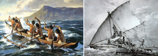
First outriggers, then outriggers with sails, and finally large enough to carry trade goods. These early Indonesian traders were seamen from early childhood and knew the sea, and their small craft were very maneuverable in coastal waters
The point often neglected by those who take Lehi through this congested archipelago is that these early seamen who plied these waters trading among the islands, were born and raised near and on the water. First migrations, then trade, were a way of life. They used canoes, then outriggers, then added sails, which are highly maneuverable in coastal waters and enabled these earlier seamen to fish far offshore, and eventually move among the islands. As Peter Bellwood put it in his article "Ancient Seafarers" in Archaeology Archive, these early seamen were "able to cross open sea, in this case the 15-mile-wide Strait of Lombok between Bali and Lombok." A fifteen-mile-wide strait is not the same as sailing in deep water across an ocean. In addition, these seamen, living on and around the sea all their lives, gaining their livelihood and even existence from the sea, were very comfortable and adept in their small outriggers and these early trade routes were developed by such men. Lehi and his family and those with them were not seamen, did not grow up on the sea, and, in fact, had never been to sea at any time prior to setting out in the ship Nephi built. To compare them with these early Indonesian traders, as Sorenson and others do, is simply out of the question.
3. Lehi sailed
southeast. If Lehi had been flying a plane, the comment is correct. However,
when sailing a ship “driven forth before the wind” (1 Nephi 18:8, 9), one has
to take into account where the winds and currents would take a “drift voyage,”
that is, a ship driven by winds and ocean currents in a southeast heading—which is never a straight
line. On a map, of course, a strait south-southeast line would lead directly to
Perth, Australia from Arabia; however, when taking into account the winds and
currents any sailing ship of the period would have had to rely on would take the
vessel southward away from Arabia, first into the Sea of Arabia with currents
and winds blowing toward the south (and slightly west—south by southwest) until
entering the Indian Ocean (South Indian Ocean Gyre), which is a circular wind
and current, blowing south then south-east. The southeast direction would take
the vessel into the West Wind Drift, a very fast circumpolar current that
circles uninterrupted around the globe, which is carried along by the
Prevailing Westerlies, a very strong wind blowing out of the west and toward
the east around the globe.

Left: Lehi’s course through the Sea of
Arabia. On a smaller scale, the course looks to be south; Right: Lehi’s Course
through the Indian Ocean and into the Southern Ocean’s West Wind Drift and
Prevailing Westerlies. On a larger scale, the course is southeast
When drawing this on
a map, the ship would have traveled mostly in a southeast direction until
entering the West Wind Drift, which then moves eastward around the planet--it is not that one finally turns east, it is the current that takes one through this curve to a final heading of east.
The article went on
to say: “Many might reasonably question why the Williams statement was given
such importance when numerous theories were being introduced at the time. The
answer to that question becomes more apparent when we realize that Williams was
the Prophet’s scribe during the years between 1833 and 1837, and because the
proposed landing site of Lehi was found on the same sheet of paper with a known
revelation regarding John the Beloved. Thus, many Saints believed the proposed
Chilean landing site must have been a revelation as well. One thing cannot be
overlooked, however - the revelation regarding John the Beloved was received in
1829 before Williams even joined the Church. Therefore, the paper with the
heading "A Revelation Concerning John the Beloved" appears to be
nothing more than a note penned by Mr. Williams in reference to the earlier
revelation - possibly during his hours spent in the school of the prophets.
Nonetheless, Williams’ proposed landing site of Lehi eventually found its way
into print.”
I apologize for
returning to this subject, but it amazes me that so much has been said and
written to disclaim this statement as a revelation that no one seems to ever
ask why was it written at all?
As has been pointed
out in earlier and recent posts, the area of Coquimbo Bay at the 30º south
latitude on the Chilean coast, and the area of La Serena adjoining it and the
Elqui Valley adjoining La Serena would not have been known to Williams or the
prophet under normal circumstances. If not a revelation, if not inspiration,
then one must confess that this wild guess or scribbled notation is one of the
luckiest and most accurate statements that could have been made in the 1830s.
The details as to how it came to be on the paper is of little consequence when
compared with how this area is such a total match to the scriptural record,
that one has to be awe-struck when looking into it. Unfortunately, the vast majority of
Theorists, with their own personal reasons, have ignored it from Day One.
The end result,
however, is it matches the course a Drift Voyage would have taken from the
south coast of the Arabian Peninsula (Nephi’s “driven forth before the wind”),
and the landing site would have been located there because of winds and
currents. And at that exact location are the precise items mentioned by Nephi
that he found on the land; i.e., wilderness, forest, climate to match his seeds
brought from Jerusalem, and the singular ore of gold, silver and copper,
including all manner of ore. All of this in the exact place Nephi’s ship would
have set in being "driven forth before the wind"—30º south latitude, along the Chilean coast, and everything within
walking distance of the shore. How could Williams or the prophet have known
this in the backwoods of where they lived in the 1830s? Much of it was not even
known until the 20th century! And further north, where Nephi would
have gone after separating from his murderous brothers, is found the matches to
all the other items described by Mormon found in the Land of Promise. What more
could one ask for?
Continuing with the
last post about a reader’s quote sent in and wanted us to comment upon it. The
quote had to do with Lehi traveling at one point nearly eastward (as they
crossed the great sand desert of Arabia), and if that didn’t also mean it was
the direction they traveled once in their ship and sailing to the Land of
Promise.
The problem and
answer lie in the need to know about the conditions, features and oceans
eastward from Arabia. And why early trade routes would not have been workable
for Nephi’s deep sea ship.
The early traders in
Indonesia and India were considered low-caste merchants and sailors, and until
recently, believed to have not traded across the sea in West Java and Kalimantanand
earlier than the fourth or fifth centuries A.D; however, it is now understood
that the very first evidence of trade in this region was between India and the
small island of Bali, off the eastern coast of Java in Indonesia, and dated to
2000 years ago by Lansing, Redd, Karafet, et all, in a 1991 study by the
Anthropology Department of the University of Arizona, Tucson. Still, this is
hundreds of years after Lehi went to sea.
Left: More than a thousand years after Lehi,
in 500 A.D., Srivijaya began to develop in Sumatra, and in the 7th
century A.D., Srivijayan trade routes in the South China Sea were just becoming
well established between the major islands and the mainland of Southeast Asia
(today: Thailand, Cambodia and Vitenam); Right: A replica of an 8th
Century A.D. Indonesian ship
In the pre-history of
Indonesia, not until the middle of the 2nd century A.D., (850 years
after Lehi), did the first Indonesia kingdom, Kutai (Dayak Kutai) rise into
existence on Borneo, followed by Tanumanagara (Taruma), beginning in 358 A.D., and
by 397 controlled 48 small kingdoms on the island of Java, and Kalingga in the
500s, also on Java, which opened trade routes with two India emperors.
Red Arrow: Sumatra; Yellow Arrow: Borneo;
Blue Arrow: Java; Green Arrow: South Sulawesi
A century later, Srivijaya
(Sri Vijaya) on Sumatra rose to power to control the trade of the Indonesia
region and was a formidable sea power until the thirteenth century. Around 600
A.D., Arab traders stopped at Indonesian ports along the way to Guangzhou and
other southern Chinese ports. By the 11th century A.D., the courts
of Borneo were exporting dammar resin, hornbill ivory, camphor to China and
India, and Buginese in Southern Sulawesi (Celebes) traded iron resourced with
Java, while the North Moluccan ports traded their legendary clove and nutmeg
with other Indonesian islands. All of which gave rise to pirate fleets based
near Palembang, on the north coast of Sumatra.
The voyages of Zheng He in 1405-1433 A.D.
Note his course close to the coasts
In 1292, Marco Polo
landed in northern Sumatra on his way back to Europe from China. And in the 12th
century, an emperor of the Ming Dynasty commissioned Grand Eunuch Zheng He to
make seven naval expeditions, each comprising hundreds of ships and crews
numbering more than 20,000 to the coasts of China to Southeast Asia, Arabia and
East Africa, using Java and Sumatra as waystops. By the fifteenth century
Melaka was a rich port city that dominated the Strait of Malacca and controlled
much of the archipelago's trade.
In all of this, it
should be kept in mind that these sea trades were within Indonesian waters and
did not move outward into the Indian Ocean or Sea of Arabia until as late as
the eighth and ninth centuries A.D.—1500 years after Lehi sailed.
In fact, mariners,
both ancient and in the days of the Age of Sail, had to consider the space on
board for food, and often ship masters could not fill their ship with enough
food for any lengthy coastal voyage, especially one involving trade which
required space for goods, and had to find sheltered beaches where drinking
water could be found, and hopefully river estuaries where both food and water
could be found.
As Arthur de Graauw
pointed out in his Ancient Ports and
Harbours, ships carried "Pilots," one in charge of setting
the course from one anchorage to another. They used “periples,” a record of earlier treks or voyages (often such secrets
were committed to memory). It was the ship pilot’s responsibility to find
sheltered areas to set in for the night where food and water could be obtained
and a safe haven from the extreme risk of sailing coastal waters at night.
Seafarers, especially
ancient ones, preferred shelters with clear landmarks on shore (such as a
typical mountain) and many shelters were needed, as seafarers followed
the coast, using safe shelters to spend the night and to escape bad weather. These
early cabotage voyages began in the
east (China) and sailed westward, with the winds all the way through Indonesia
ports and to Arabia and East Africa. Returning was a different matter, for
moving against the winds and currents required a much slower voyage with
constant evening stops. In fact, as late as the twelfth century, Portuguese
sailors trying to sail to the Spice Islands (Indonesia) across the Indian Ocean
(west to east), took them three and four times as long as sailing back (east to
west) along the same route. They finally found that sailing down along the
Southern Ocean in the swift current toward Australia, then swinging north along
the eastern curve of the South Indian Ocean Gyre, took them directly to Indonesia, sailing from
south to north.

The basic winds through the Sea of Arabia,
Indian Ocean, and Indonesia. Note that through Indonesia, all winds flow
basically from east to west, blocking any movement of a ship “driven forth before
then wind” from traveling from east to west through the archipelago and into
the Pacific
Still, sailing in these early days, especially among
islands, was very different than one might expect living in our day and age.
The Captain simply did not just grab the spoked wheel and holler out to haul in
the lines and sail away—he had the help of several people, including an expert who
was usually third in command under the Captain (Captain-General) and the Master
(usually the owner or his representative), called a Pilot.
As an example, when Vasco da Gama sailed around
Africa on his wide swing out into the Atlantic,
he had a Gujarati Pilot named Ahmad ibn Majid aboard to direct the course,
however the famous Arab pilot mistook the town of Capna for the rich Hindu port
of Calicut, the principle market of trade for
precious stones, pearls, and spices, and the ship anchored six miles down the
coast from their destination. Portuguese Pedro Álvares Cabral sailed to Brazil with a fleet of thirteen ships, then down around the tip
of Africa in 1500 following de Gama’s route, he had a Pilot named Alfonso Lopes
guiding his lead ship.
Captain Cabral (white arrow) standing on the
Main Deck among the crew, pointing to the Brazilian coast; the ship’s Pilot,
Alfonso Lopes (white arrow), stands on the Quarter Deck calling out the sight
of land
Each of Columbus’
three ships had a pilot. The Santa Maria,
Columbus’ flagship, had Sancho Ruiz (Cristobal Garcia Xalmiento was Pilot of
the Pinta, and Pedro Alonso Niño,
Pilot, and Bartolome Roldan, apprentice pilot, of the Niña).
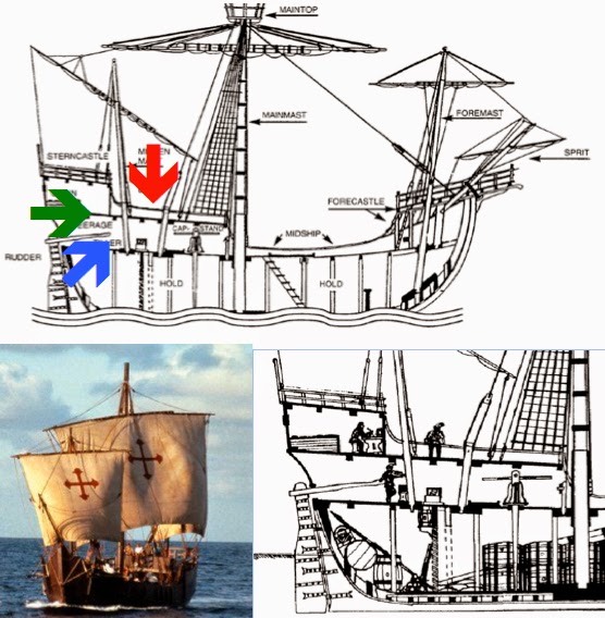
Top: The Captain and Pilot (Red Arrow) stood
on the Quarter Deck (Green Arrow), open to the sky and ocean about them; the
Helm or Steerage (Blue Arrow) was at the rear of the Main Deck (because that
was where the tiller was located), with no view of the ocean or sky, blocked
out by the Quarter Deck above and the masts and Forecastle forward—however, the
experienced sailor steering could see out the back of the ship at the wake, and
if it was straight, he was steering a straight course. The Captain oversaw the
entire ship while the Pilot was in charge of the ship’s steerage, with lookouts
above on the maintop (crow’s nest) and Forecastle to shout out directions when
the ship neared land, shoals, reefs, etc.; Bottom Left: Columbus’ ship, the
“Santa Maria”; Bottom Right: Close-up of the ship’s stern with the experienced
seaman at the tiller, with the Captain in his cabin writing in his log, and the
ship’s Pilot looking out to sea
(See the next post,
“They Turned Eastward” – Part III,” for more information on the article about
sailing directly eastward and the very real complications of such an attempt)
A reader sent in this
quote and asked what we thought of it:
“We learn of the direction Lehi and his family journeyed once they left
Jerusalem in 1 Nephi 16:13
where we read they traveled in a south, southeast direction. Continuing in that
direction would have taken them to 19 degrees north latitude. In
chapter 17:1 we learn they "did
travel eastward from that time forth." Thus, eastward to the Sea of
Arabia. Apparently early theorists assumed the directions given in 1 Nephi were not just the direction
they maintained while they were traveling on foot but may have been intended to
include the general direction they traveled even after they set sail. Therefore,
in their efforts to follow the journey to a reasonable conclusion, simply
followed the sailing party eastward across the pacific to a likely landing site.”
Example of “simply followed the sailing party eastward
across the pacific to a likely landing site.” However, such would not be very
likely because of what lay between Arabia and the Pacific Ocean
This statement is
found on the “Book of Mormon Lands” website, under the page heading: “The
Evolution of Book of Mormon Geography,” with excerpts from Phyllis Carol
Olive’s book, The Lost Lands of the Book
of Mormon. This statement was half of the second paragraph, however, the reader
failed to send in the second half of that paragraph, which reads:
“The final piece of information given in the Williams’ statement
indicates that Lehi and his people sailed in a southeast direction and landed
in Chile along the western borders of South America. Now, since traveling
southeastward, as described in the comment by Williams, would have taken them
in a direct course toward the continent of Australia, and beyond toward
the Antarctic, they would, of necessity, have had to turn due east at some
point to reach the west coast of Chile at thirty degrees south latitude.”
So while the reader
asked for an opinion on the first statement, we will endeavor to respond to
both statements since they are inseparably connected.
As for our answer,
consider the following three points:
Lehi had been traveling south-southeast
along the Red Sea, then turned nearly eastward (blue arrow) after that
1. People assumed, though there is no comment or
suggestion for it, that the term “did travel eastward from that time forth” (1 Nephi 17:1), had reference to more than
the next location (Bountiful). Assumptions are never a wise basis for an
opinion on such slim information and such an obvious single subject, i.e.,
traveled eastward from that time forth…until they “did come to the land which
we called Bountiful” (1 Nephi 17:6).
2. Continuing east from Bountiful “in their efforts to follow the journey to a reasonable
conclusion, simply followed the sailing party eastward across the pacific to a
likely landing site,” is not the simple idea made to seem
here. Between Arabia and the Pacific are 17,000 islands comprising 699,548
square miles in a total area (including seas) of 741,096 square miles, in the
closely compacted area of the Indonesian archipelago. Besides the islands, the
East Indian Archipelago (Indonesia) encompasses twelve seas, two gulfs and one
straight, each with its own difficulties of negotiating currents, shoals, and
daily squalls and torrential rain—even today with engines, GPS, and radar, the
area “has a notorious reputation for being navigationally difficult.”

Map showing the larger of the 17,000 islands of
Indonesia through which Lehi would have had to negotiate. Note the continual
course changes that would be needed by inexperienced people who had never
before been to sea--an in a sailing boat "driven forth before the wind." It should also be noted that this is considered the most
difficult and dangerous sailing course on the planet
Far too often,
uninformed comments like that are made by individuals who are unfamiliar with
the Sea. When it comes to sailing, two terms are important to keep in
mind: 1) Pilotage or Cabotage,
which is the art of sailing along the coast using known landmarks; and 2) Navigation, which is the art of sailing
long distances out of sight of land. The former is the use of fixed visual
reference of the shore, such as cliffs, rock, capes and points, to guide a ship
to its destination, and is dependent on the pilot being able to recognize the
visual references in order to make use of them, or capable of discovering them
from a map. Obviously, such travel in 600 B.C. had to be done in the daytime,
and with enough visibility, where the natural features could be seen from the
ship.
Cabotage, an original
shipping term, meant “trade or transport in coastal waters,” from the French, Caboter, meaning “to sail along the
coast.” It was the term later applied to the early traders before the Age of
Sail, who plied the coastal waters.
Top: The early trade routes established by
Cabotage vessels sailing by day and putting in at night, keeping in view of
known landmarks along the coast; Bottom: The reason they put in at night—this
is shot off the starboard bow, with the wheel in bottom left and rigging to
right. Note that except for the moon trail across the water, nothing else can
be seen though the boat is less than a mile from shore
The latter is Navigation,
and prior to the instruments known in the Age of Sailing, was often little more
than “dead reckoning.” Sometimes called ded,
for “deduced” reckoning (DR), where the navigator finds his position by
measuring the course and distance he has sailed from some known point.
Even though Columbus had a magnetic compass (they had been known in Europe
since at least 1183), in his first voyage, he returned mostly by dead reckoning
and was off two hundred miles when nearing the Azores. On rare occasions, an
early sea captain might chance a dead reckoning voyage between two very well
known points, with the advanced point one that if missed, a location could
still be determined when reached from the known landmarks.

Consequently, for all
those theorists who like to claim man was sailing the deep ocean, running
between Arabia and Indonesia, before a magnetic compass was invented (left),
might want to rethink their view. Without a compass, in open sea where there
are no landmarks, is like sailing blindfolded--you have no idea where you are, or where you are going. As an example, as late as the 8th or 9th
century A.D., Viking merchants navigated their “knarr”—a ship that was wider, deeper, and
shorter than the Viking longship and used for long sea voyages—on regular
journeys over the North Atlantic connecting their settlements in Norway,
Iceland and Greenland. Although they had no magnetic compass, they were able to
sail due West or due East courses by using the Sun at daytime and the stars at
night to verify their course. From their port of departure, they would sail
along the Norwegian coast North or South until they had reached the Latitude of
their destination and then sailed on a constant course West to their port of
destination. The prominent ice-covered mountain peaks of Iceland and Greenland
were used as landmarks to approach these coasts. By experience, they knew
approximately how long their voyages would take so that they also applied a
kind of Dead Reckoning combined with an elaborate celestial knowledge of which
they took advantage for their constant-latitude navigation.

Left: the shorter, stubbier and deeper
Viking Knarr; Right: The more familiar narrower, shallower Viking Long Ship
While that worked for
the Vikings at their latitude, moving straight as an arrow so to speak, sailing
in the Indian Ocean or through Indonesia could not have been done this way. Nor
could the unique sailing of the Polynesians who moved basically due north and
due south with a wide ocean around them, have been used by these early traders,
or up to or even during the Age of Discovery.
That leaves us only
one explanation for Lehi’s deep sea voyage to the Land of Promise and it can be
summed up in one word—Liahona. However, knowing changes of direction during the
type of island-hopping voyage one would have taken through Indonesia in 600
B.C., would not have helped people who had never been to sea before, let alone
who were not experienced mariners.
(See the next post,
“They Turned Eastward” – Part II,” for the third point and more information on the article about
sailing directly eastward and the complications of such an attempt)