
Continuing
with Alan C. Miner’s convoluted views on the geography of the narrow neck of
land, we find that he tries to change Mormon’s description of the narrow neck to a west coastal corridor.
Resuming now from the last post with the second problem of this, 2) is in the scriptural record, there is little mention or suggestion of a narrow corridor along the West Sea coastal area. In fact, there is almost no comment about the west coast of the Land of Promise in the entire scriptural record regarding population movement, development, or settlement up and down the coastal area. In fact, there are few things mentioned along the west sea coastal area at all. There is the wilderness of Hermounts (Alma 2:37); there is the narrow strip of wilderness that separated the Land of Nephi from the Land of Zarahemla (22:27; 50:11); and a wilderness then ran along the west coastal area for a short distance (Alma 22:28); Bountiful bordered along the west sea (Alma 22:33); there was a sea on the west of the narrow pass through the narrow neck of land (Alma 50:34); Moroni was camped with his army along the west sea (Alma 52:11); Lamanites had an army on the west sea, south (Alma 53:8); there was a settlement(s) along the south by the west sea (Alma 53:22); Hagoth has his shipyard along the west sea near the narrow neck of land (Alma 63:5); Moronihah made a stand along the wall from the west sea to the east (Helaman 4:7); Mormon fought a battle along the west sea in the land of Joshua (Mormon 2:6). While there are grounds to suggest an eastern corridor since much discussion and movement up and down the eastern seaboard is covered in all of these references, especially in Alma, there is almost nothing to suggest a west sea coastal corridor.
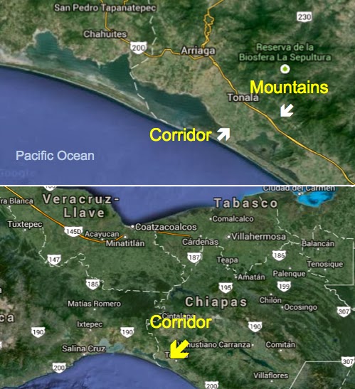 Top: Miner's western coastal corridor; Bottom: That corridor in relation to the rest of the Isthmus of Tehuantepec. Obviously, an invading army could simply bypass any defensive position within this corridor and invade the Land Northward anywhere along the many passes through the 144-mile wide isthmus
Miner, however, is still trying to sell his narrow neck along this western seacoast, as Joseph Allen has tried to do. Miner adds: “It is bordered on the west by the Pacific and on the east by a formidable mountain land barrier—the Sierra Madre mountain range. In the area shown, the neck narrows, and there is a natural pass that leads into the land northward. Heavy fortifications have been discovered at this site just south of Tonala, Mexico. Just to the north of this pass the land is dry and desolate—to the south it is rich and verdant.”
With Miner's description one can only wonder why there was not more activity in this area mentioned in the scriptural record. However, there is not. How Moroni marched his army northward we are not told, however, when Moriancumr had a choice, he chose to move northward through the center of the land (Helaman 1:25), even though that was where the Nephites’ greatest populace was located (Helaman 1:24), which does not suggest a narrow coastal corridor.
In addition, Miner tells us that to the south of this pass it is rich and verdant,” which means most of the west coastal area of his Land of Zarahemla would be ideal for settlement and crop production, yet there is not one word of any settlement, city, or Nephite holdings along this coast in the scriptural record until you go far south (Alma 53:8). Compare that with the east coast where cities were built all along the coastal area from the Land of Nephite clear to the land of Mulek. In addition, there are almost no major developments along this coastal strip even today, until you travel 50 miles eastward to Mapasterpec, and then another 70 miles to almost the Guatemala border before reaching Tapachula in the area of Mazatlan, it being the only coastal city in the first 200 miles.
 The circle area is where Miner feels the Nephites withstood the Robbers; however, Mormon ltells us they were in thel "center of their land, from Bountiful to Zarahemla" (3 Nephi 3:23)
Miner continues with, “Because of all the natural defenses here and the archaeological evidences in the area that match the descriptions from the Book of Mormon, some scholars believe this may be the region where the people gathered together to stand firm against the Gadiantons.”
First of all, while Mesoamericanists continue to claim that archaeological evidence supports the Book of Moron era in Mesoamerica, the same can be said, and with far more accuracy in Andean Peru; however, it might be of interest exactly what archaeological evidences Miner thinks might be found in this area along the western coastal plain that “match the descriptions from the Book of Mormon,” since we have already shown that there is almost no mention of anything in that area in the scriptural record. If this coastal plain was along the east coast, then Miner at least would have some grounds to make that statement. And if there were such defenses along this coastal plain, why is there almost no mention of Moroni or Moronihah fighting any battles there? Secondly, the area where the Nephites battled the Gadianton Robbers was not along the coastal area of either sea.
Miner continues with: “The descriptions given in the Book of Mormon of the narrow neck of land and the narrow pass that led into the land northward so perfectly match this region that it is hard not to recognize this area as being the most probable candidate.”
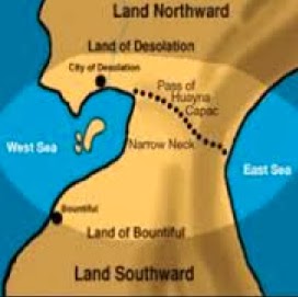
Unfortunately, Mormon would have a hard time recognizing Miner’s model. The ancient prophet told us that the Land of Bountiful was separated from the Land of Desolation by a narrow neck that divided the Land Northward from the Land Southward (Alma 22:32), and that this narrow neck was the width of a day-and-a-half journey for a Nephite, and by controlling this area, they had hemmed in the Lamanites on the south (Alma 22:33); he also told us that Desolation was on the north of Bountiful (Alma 22:31), and that the Land Southward was surrounded by water except for this narrow neck of land (Alma 22:32). One look at Miner’s coastal corridor and not one of these scriptural references can be seen except in Miner’s eyes. In addition, the Land of Nephi was separated from the Land of Zarahemla by a narrow strip of wilderness that ran from the Sea East clear to the Sea West (Alma 22:27), and there was a narrow pass that was flanked on the east and on the west by seas (Alma 50:34).
Undaunted by his incongruous model, Miner goes on to write: “The references in the Book of Mormon do not give a clear indication that the narrow neck of land is surrounded by water, only that there is a sea on the west.”
 There
is one and only one land area between the Land Southward and the Land Northward
(Alma 22:, yet we are told that a pass or passage also goes from the Land
Southward to the Land Northward: “The land of Nephi and
the land of Zarahemla were nearly surrounded by water” (Alma 22:32)—so why were
they nearly surrounded and not surrounded? Because Mormon tells us, to the
north of the Land of Nephi and the Land of Zarahemla (which contained the Land
of Bountiful), there was “a smallneck of land between the Land Northward and
the Land Southward” (Alma 22:32). Ether, also aware of this “narrow neck of
land” tell us that it was “where the sea divides the land” (Ether 10:20). Now
what better description can you have than the narrow neck of land was flanked
by water on two sides, and extended into the Land Northward from the Land
Southward? If further clarification is needed, we also find that Hagoth built
him an exceedingly large ship “on the borders of the land Bountiful, by the
land Desolation, and launched it forth into the west sea, by the narrow neck
which led into the land northward” (Alma 63:5).
There
is one and only one land area between the Land Southward and the Land Northward
(Alma 22:, yet we are told that a pass or passage also goes from the Land
Southward to the Land Northward: “The land of Nephi and
the land of Zarahemla were nearly surrounded by water” (Alma 22:32)—so why were
they nearly surrounded and not surrounded? Because Mormon tells us, to the
north of the Land of Nephi and the Land of Zarahemla (which contained the Land
of Bountiful), there was “a smallneck of land between the Land Northward and
the Land Southward” (Alma 22:32). Ether, also aware of this “narrow neck of
land” tell us that it was “where the sea divides the land” (Ether 10:20). Now
what better description can you have than the narrow neck of land was flanked
by water on two sides, and extended into the Land Northward from the Land
Southward? If further clarification is needed, we also find that Hagoth built
him an exceedingly large ship “on the borders of the land Bountiful, by the
land Desolation, and launched it forth into the west sea, by the narrow neck
which led into the land northward” (Alma 63:5).
Miner adds: “The distance across this line between the two ecosystems at the north end of this narrow neck of land is about a day and a half's journey.”
Note that Miner tells us this distance Mormon mentioned across the width of the narrow neck was at the north end of the neck, but we simply do not know that, nor do we know that this neck was wider or narrower in one part or the other. It was “small” (Alma 22:32) and small would suggest a more even neck than one that is dramatically wider in one point over another, which it seems would require a larger or longer neck. But it is the adding of language where there is absolutely no support, indication, or suggestion in the scriptural record that Miner and most other Mesoamericanists do that is not helpful, and certainly not good scholarship, for it can be misleading, as well as self-serving.
(See the next post, “Other Thoughts on Theorist’s Views of the Narrow Neck—Part IV,” for more on Alan C. Miner’s views on the Narrow Neck of Land and how he thinks it fits into Mesoamerica despite so much scriptural comments to the opposite)
Resuming now from the last post with the second problem of this, 2) is in the scriptural record, there is little mention or suggestion of a narrow corridor along the West Sea coastal area. In fact, there is almost no comment about the west coast of the Land of Promise in the entire scriptural record regarding population movement, development, or settlement up and down the coastal area. In fact, there are few things mentioned along the west sea coastal area at all. There is the wilderness of Hermounts (Alma 2:37); there is the narrow strip of wilderness that separated the Land of Nephi from the Land of Zarahemla (22:27; 50:11); and a wilderness then ran along the west coastal area for a short distance (Alma 22:28); Bountiful bordered along the west sea (Alma 22:33); there was a sea on the west of the narrow pass through the narrow neck of land (Alma 50:34); Moroni was camped with his army along the west sea (Alma 52:11); Lamanites had an army on the west sea, south (Alma 53:8); there was a settlement(s) along the south by the west sea (Alma 53:22); Hagoth has his shipyard along the west sea near the narrow neck of land (Alma 63:5); Moronihah made a stand along the wall from the west sea to the east (Helaman 4:7); Mormon fought a battle along the west sea in the land of Joshua (Mormon 2:6). While there are grounds to suggest an eastern corridor since much discussion and movement up and down the eastern seaboard is covered in all of these references, especially in Alma, there is almost nothing to suggest a west sea coastal corridor.
Miner, however, is still trying to sell his narrow neck along this western seacoast, as Joseph Allen has tried to do. Miner adds: “It is bordered on the west by the Pacific and on the east by a formidable mountain land barrier—the Sierra Madre mountain range. In the area shown, the neck narrows, and there is a natural pass that leads into the land northward. Heavy fortifications have been discovered at this site just south of Tonala, Mexico. Just to the north of this pass the land is dry and desolate—to the south it is rich and verdant.”
With Miner's description one can only wonder why there was not more activity in this area mentioned in the scriptural record. However, there is not. How Moroni marched his army northward we are not told, however, when Moriancumr had a choice, he chose to move northward through the center of the land (Helaman 1:25), even though that was where the Nephites’ greatest populace was located (Helaman 1:24), which does not suggest a narrow coastal corridor.
In addition, Miner tells us that to the south of this pass it is rich and verdant,” which means most of the west coastal area of his Land of Zarahemla would be ideal for settlement and crop production, yet there is not one word of any settlement, city, or Nephite holdings along this coast in the scriptural record until you go far south (Alma 53:8). Compare that with the east coast where cities were built all along the coastal area from the Land of Nephite clear to the land of Mulek. In addition, there are almost no major developments along this coastal strip even today, until you travel 50 miles eastward to Mapasterpec, and then another 70 miles to almost the Guatemala border before reaching Tapachula in the area of Mazatlan, it being the only coastal city in the first 200 miles.
Miner continues with, “Because of all the natural defenses here and the archaeological evidences in the area that match the descriptions from the Book of Mormon, some scholars believe this may be the region where the people gathered together to stand firm against the Gadiantons.”
First of all, while Mesoamericanists continue to claim that archaeological evidence supports the Book of Moron era in Mesoamerica, the same can be said, and with far more accuracy in Andean Peru; however, it might be of interest exactly what archaeological evidences Miner thinks might be found in this area along the western coastal plain that “match the descriptions from the Book of Mormon,” since we have already shown that there is almost no mention of anything in that area in the scriptural record. If this coastal plain was along the east coast, then Miner at least would have some grounds to make that statement. And if there were such defenses along this coastal plain, why is there almost no mention of Moroni or Moronihah fighting any battles there? Secondly, the area where the Nephites battled the Gadianton Robbers was not along the coastal area of either sea.
Miner continues with: “The descriptions given in the Book of Mormon of the narrow neck of land and the narrow pass that led into the land northward so perfectly match this region that it is hard not to recognize this area as being the most probable candidate.”
Unfortunately, Mormon would have a hard time recognizing Miner’s model. The ancient prophet told us that the Land of Bountiful was separated from the Land of Desolation by a narrow neck that divided the Land Northward from the Land Southward (Alma 22:32), and that this narrow neck was the width of a day-and-a-half journey for a Nephite, and by controlling this area, they had hemmed in the Lamanites on the south (Alma 22:33); he also told us that Desolation was on the north of Bountiful (Alma 22:31), and that the Land Southward was surrounded by water except for this narrow neck of land (Alma 22:32). One look at Miner’s coastal corridor and not one of these scriptural references can be seen except in Miner’s eyes. In addition, the Land of Nephi was separated from the Land of Zarahemla by a narrow strip of wilderness that ran from the Sea East clear to the Sea West (Alma 22:27), and there was a narrow pass that was flanked on the east and on the west by seas (Alma 50:34).
Undaunted by his incongruous model, Miner goes on to write: “The references in the Book of Mormon do not give a clear indication that the narrow neck of land is surrounded by water, only that there is a sea on the west.”
Miner adds: “The distance across this line between the two ecosystems at the north end of this narrow neck of land is about a day and a half's journey.”
Note that Miner tells us this distance Mormon mentioned across the width of the narrow neck was at the north end of the neck, but we simply do not know that, nor do we know that this neck was wider or narrower in one part or the other. It was “small” (Alma 22:32) and small would suggest a more even neck than one that is dramatically wider in one point over another, which it seems would require a larger or longer neck. But it is the adding of language where there is absolutely no support, indication, or suggestion in the scriptural record that Miner and most other Mesoamericanists do that is not helpful, and certainly not good scholarship, for it can be misleading, as well as self-serving.
(See the next post, “Other Thoughts on Theorist’s Views of the Narrow Neck—Part IV,” for more on Alan C. Miner’s views on the Narrow Neck of Land and how he thinks it fits into Mesoamerica despite so much scriptural comments to the opposite)


No comments:
Post a Comment