Wednesday, July 31, 2013

Smite the Seed of My Brethren – Part I

Perhaps it is worthwhile to remind us all of the developments that led both to the creation of the United States and the treatment of the indigenous natives (American Indians) of the Western Hemisphere.
“And the Spirit said unto me: Behold, what desirest thou? And I said: I desire to behold the things which my father saw. And the Spirit said unto me: Believest thou that thy father saw the tree of which he hath spoken?”
First of all, Nephi was given a vision upon his request to see what his father, Lehi, had seen. After seeing the tree of life, the birth of the Savior, and his mission on Earth, and the Nephite-Lamanite wars and the demise of his own people, Nephi tells us: “And it came to pass that I looked and beheld many waters; and they divided the Gentiles from the seed of my brethren” (1 Nephi 13:10). That is, Nephi’s vision covered both the Lamanites, after they had utterly annihilated the Nephites, in the Land of Promise, and also the gentiles on the other side of the Sea. Evidently, the condition of the Lamanites was one that caused a negative feeling as he told Nephi, “Behold the wrath of God is upon the seed of thy brethren” (1 Nephi 13:11).
Part of what Nephi saw was also a man among the gentiles on the other side of the Sea, Nephi “beheld the Spirit of God, that it came down and wrought upon the man; and he went forth upon the many waters, even unto the seed of my brethren, who were in the promised land” (1 Nephi 13:12). There is little disagreement that this man was Columbus, who was led by the Spirit to “discover” the Western Hemisphere. In 1950, Elder Spencer W. Kimball testified that God “inspired a little boy, Christopher Columbus, to stand on the quays in Genoa, Italy, and yearn for the sea. He was filled with the desire to sail the seas, and he fulfilled a great prophecy made long, long ago that this land, chosen above all other lands, should be discovered. And so when he was mature, opportunity was granted to him to brave the unknown seas, to find this land . . . and to open the door, as it were.”
It was Columbus himself who said to the king and queen of Spain, “I came to your majesty as the emissary of the Holy Ghost.” From the writings of Christopher Columbus we find the following significant statement: “It was the Lord who put into my mind (I could feel his hand upon me) the fact that it would be possible to sail from here to the Indies. All who heard of my project rejected it with laughter, ridiculing me. There is no question that the inspiration was from the Holy Spirit because He comforted me…. For the execution of the journey to the Indies, I did not make use of intelligence, mathematics or maps. It is simply the fulfillment of what Isaiah had prophesied.”
LtoR Top to Bottom: Columbus presenting his plan to the king and queen of Spain; the queen seeing Columbus off; Columbus landing in the Caribbean and proclaiming the land for Spain; Columbus reporting back to the king and queen with gifts and some Indians from then New World
In all of this vision Nephi received, he also saw the coming of the European gentiles to the Land of Promise, the war for North America the British fought with the French, and the many European nations involved in the discovery and conquest of the New World (1 Nephi 13:13-15). Nephi also saw the eventual development of the American colonies into the United States of America (1 Nephi 13:16-19).
Before these events, however, Nephi saw what happened to “his brethren,” that is, the Lamanite people who had descended down through time from the last battle with the Nephites in 365 A.D., and the wars among themselves that followed at least through 421 A.D., at which time we are told “there is no end in sight” (Mormon 8:8).
When the Spanish arrived, they were brutal in their destruction of the Aztec, Maya and Inca, but perhaps nowhere were they as bloody as in their treatment of the Inca and adjoining cultures (tribes and clans) of the Andean area, from Ecuador to Chile.
The treatment Francisco Pizarro Golnzalez inflicted upon the Inca was one of bloody brutality, cruel deception and lies. He reduced a thriving empire to ashes and made slaves of its populace, all in the name of God
Hernan Cortes, conqueror of the Aztecs, Francisco, Pedro de Alvarado, conqueror of the Maya, and Pizarro, conqueror of the Inca, were all men of limited humanity. It is recorded that they were cruel, violent men who did not flinch from torture, mayhem, murder and rapine, enjoying inflicting pain, cruelty, degradation, and humiliation on others. When they weren’t fighting and killing the indigenous natives, they were fighting among themselves. Perhaps the worst of them was Pizarro, who was known to have moments of great cruelty. It is recorded that after his puppet Emperor, Manco Inca, went into open rebellion, the “ruthless Pizarro” ordered that Manco's wife Cura Ocllo be tied to a stake and shot with arrows: her body was floated down a river where Manco would find it. Later, Pizarro ordered the murder of sixteen captured Inca chieftains: one of them was burned alive. His treacherous double cross of the Inca leader, Atahuallpa, was overshadowed by his double cross of his own lieutenants, such as Diego de Almagro, who never forgave the conqueror, causing a civil war among the armies for which Pizarro had him hung.
After the conquest, the Spanish had three terms that applied to their dealings with the Indians: the encomiendo, the mitad, and the repartimiento, each indicating a form of injustice. First, the conquerors divided the country between themselves, and the encomiendos were rights granted them to hold the Indians for a number of years as workers in their fields or mines. Under these grants, the natives were converted into beasts of burden, and forced to do the hardest work without the least compensation. They were forced to labor all day long under the burning tropical sun, to dive into the sea in search of pearls for their masters, or to toil buried from the light of day in the depths of the mines. It is not surprising that these miserable slaves, accustomed to a life of indolence and ease, perished as if exposed to a killing plague.
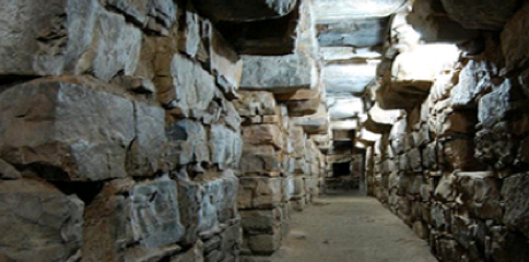
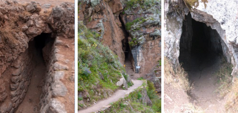
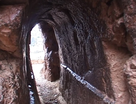
The Spanish mines in Peru were death traps to the Inca slaves who were forced to work in them—80% died during their six month forced labor in the mines
Second, the mitad was a law requiring every man from the age of 18 to 50 to render bodily service, with the natives of each mining colony of South America being divided into seven sections, each of which had to work six months in the mines. Every mine-owner could demand the number of Indians he needed—in Peru alone fourteen hundred mines were worked, and labor of this kind was in constant demand. The Indians looked upon this “service” as a death sentence and when called into the mines, they gave away all their possessions to their relatives, and went through a funeral services, as if they were already dead—80% did not survive this six month tour in the mines, killing a reported 8 million victims. For those who did survive, they were almost always in debt to the mine owners for the cost of their food, clothing, and liquor, and thus unable to pay off the debt, were enslaved for life.
Further explanation of the terrible and unconscionable horrors the Spanish imposed upon the Indians for the next two hundred years is not meet for this venue, suffice it to say that the degradations were beyond description and certainly meets the description Nephi wrote when he said “and I beheld the wrath of God, that it was upon the seed of my brethren; and they were scattered before the Gentiles and were smitten” (1 Nephi 13:14).
(see the next post, “Smite the Seed of My Brethren – Part II,” for more on the development of the Western Hemisphere and the creation of the various countries formed by the gentiles and their treatment of the indigenous natives—the American Indians)

Sunday, July 28, 2013

The Advanced Marvels of Tiahuanaco and Other Sites – Part II

Continuing with the last post about the ancient site of Tiahuanco (Twanaku), which included the areas of Puma Punku, Arkapana, Titicaca and the Altiplano. This magnificent ancient stonework that was dismantled soon after then Spanish arrived, bore testimony to an advanced society of the past, dating into B.C. times who erected the entire city that some claim housed as many as 1.2 million people, including its surrounding environs.
Yet, Tiahuanaco is by no means unique to the area of Andean Peru, for scattered throughout the Andes are several fortresses of very similar design, all predating the ancient Incas by an unknown span of time—and all probably built by the same race of men who constructed Tiahuanaco. People unknown to history, and unknown even to the Inca who occupied the areas this ancient people built.
A unique layout of 233 stones on the dead-flat platform at El Enladrillado in Chile, 12 to 16 feet high, 20 to 30 feet long, and weighing several hundred tons, these stones were laid out in an obvious pattern across a level ground
In Chile, high on the plateau of El Enladrillado and well within the borders of the old Inca empire, are 233 stone blocks that have been placed geometrically in an amphitheater-like arrangement. The blocks are roughly rectangular, some as large as twelve to sixteen feet high, twenty to thirty feet long, and weighing several hundred tons. As at Tiahuanaco, huge chairs of stone have also been found in disarray among the ruins, each weighing a massive ten tons. But perhaps the most important find at El Enladrillado, Altos de Lircay, Chile, was the discovery of three standing stones at the center of the plateau—each is three to four feet in diameter and perfectly aligned with magnetic north, while a line through one of these and the third stone points to the midsummer sunrise.
To the north, at Ollantaytambo, is another pre-Inca fortress, with rock walls of tightly fitted blocks weighing between 150 and 250 tons each. Most of the blocks consist of very hard andesite, the quarries for which are situated on a mountaintop seven miles away. Somehow, at an altitude of 10,000 feet, the unknown builders carved and dressed the stone (using tools the nature of which we can only guess to penetrate such hard rock), lowered the two-hundred-ton blocks down the mountainside, crossed the river canyon with 1,000-foot sheer rock walls, then raised the blocks up another mountainside and placed them in the fortress complex. According to South American antiquarian Hyatt Verrill, “mere men, no matter how many—Indian or otherwise—could not duplicate this feat using only their muscle power and the stone implements or crude metal tools, ropes and rollers that we know about.” As Verrill noted, “It is not a question of skill, patience and time.” It would be a matter of a higher knowledge than we know about even today.
Ollantaytambo is a hill top fortress that involves thousands upon thousands of stones, some weighing many tons and intricately carved, positioned up a hillside with an extensive terraced entrance
Was this some of the “Great Things” the Lord told Nephi about? (1 Nephi 18:3).
Between Ollantaytambo and Tiahuanaco, lies another example of these engineering geniuses, that of Sacsayhuaman above Cuzco. It rests on an artificially leveled mountaintop at an altitude of 12,000 feet and consists of three outer lines of gargantuan walls, 1,500 feet long and 54’ wide, surrounding a paved area containing a circular stone structure believed to be a solar calendar. The ruins also include a 50,000-gallon water reservoir, storage cisterns, ramps, citadels and underground chambers. But what is truly remarkable about this fortress is the stonework.
Here extremely skilled stonemasons fitted blocks weighing from fifty to three hundred tons into intricate patterns. A block in one of the outer walls, for example, has faces cut to fit perfectly with twelve other blocks. In addition, other blocks were cut with as many as ten, twelve, and even thirty-six sides. Yet all the blocks fit together so precisely that a mechanic’s thickness gauge could not be inserted between them.
The stonework of this pre-historical people dating into the B.C. period is remarkable, with these intricate cuts and fittings, and with such unusual patterns and joints
Modern historians can claim this was built by the Inca all they want, but when the Spanish arrived, the Inca had no idea who built Sacsayhuaman, nor when or how it was built, even though modern historians claim it was built within 100 years of the conquest. In addition, the magnificent fortress is not mentioned, nor does it figure into any of the Inca legends. And lastly, the Inca had no knowledge of higher mathematics, no written language, no iron tools, and did not even use the wheel, yet modern historians want to claim they built Sacsayhuaman and other sites around the Sacred Valley. The truth of the matter is, all these sites were built by others, dating back into B.C. times, and when the Inca arrived on the spot, they simply moved into these buildings and occupied them.
It is interesting that when the Lord wanted to help man for his own purposes, he told Noah exactly how to build his Ark, even to the overall dimensions; when he wanted the Brother of Jared to build eight barges, he told him exactly how to do so; when the Lord wanted a temple built to him, he gave Israel the overall dimensions, the interior design, and what and how things were to be displayed within it; when the Lord wanted Nephi to build a ship, he told him exactly how to construct it, which was not after the manner of men, but entirely different. Let us not forget that the Lord has been intricately involved in numerous building efforts through the centuries, and in giving man knowledge of how to build, create, and accomplish certain things—certainly, when he had Nephi up on the mountain, not only did he instruct Nephi, who went to the mount often, on how to build his ship, but also instructed him on many “great things” (1 Nephi 18:3).

Saturday, July 27, 2013

The Advanced Marvels of Tiahuanaco – Part I

High in the Andes, on the picturesque shores of Lake Titicaca, stand the remains of a city of startling dimensions—and no one knows its origins. Not even the oldest living Indian could tell of its history when questioned by the Spanish after the conquest of the area in 1549.
The original stones and buildings were torn down by the Spanish and subsequent locals to build their own structures; the railroad broke up the huge blocks weighing hundreds of tons for roadbase beneath their tracks. A rebuilding program to rebuild Tihuanaco is underway, but it is slow progress
Some South American archaeologists consider that Tihuanaco or Tiwanacu, a name given the area by the Spanish (no one knows what its builders called the city, as there are no records available) was built at a time when the Land was almost two miles lower than it now is. In fact, an ancient and deserted seaport is located nearby. This theory is based on changes in the Andean Ridge, as interpreted by deposits of calcareous lime or “water mark” lines on cliffs and mountains, and on the belief that this section of the Andes and Lake Titicaca were thrust upward, destroying and emptying the city, as well as other centers of this prehistoric culture. One things is certain, it was not built by the Indians of the surrounding area, the Inca or their immediate ancestors.
According to Charles Etienne Brasseur de Bourbourg, a noted French writer, ethnographer, historian and archaeologist, “There were in these regions, at that remote date, convulsions of nature, deluges, terrible inundations, followed by the upheaval of mountains, accompanied by volcanic eruptions. These traditions, traces of which are also met within Peru and Bolivia, point to the conclusion that man existed in these various countries at the time of the upheaval of the Cordilleras, and that the memory of that upheaval has been preserved.” He also stated about “convulsions and inundations, profound disturbances, and mountains and volcanoes that suddenly rose up.”
According to Pedro Cieza de Leon, the self-acclaimed first chronicler of the Indies, wrote about the Inca and their history and said, “whoever its engineers of Tiahuanaco were, they certainly were not related to the Indians in any way.” It is also obvious that there is a foreign element apparent both from the style of the structures and from the fact that the statues of Tiahuanaco depict strange-looking men with beards—not the usual Indian faces, which tend to be devoid of beard growth. The society that developed the entire Tiahuanaco area had technicalities that astounded the conquistadors, and even the engineers of today.
Note the size of these huge blocks of stone compared to the man on top of one. Originally they were covered with Andesite (a hard igneous volcanic rock, and a name derived from the Andes Mountains, which is often used today for paving and décor stones)
Archaeologists who have studied the site since its discovery by the Spaniards have uncovered features thought to be unknown to the ancients. The Akapana Temple (“The One who holds the Thunderbolt, the descriptive name of Viracocha, the Creator God), also called the by archaeologists, the “Hill of Sacrifices,” is one of the three important temple sites. The Arkapana is the largest terraced step pyramid of the city, and was once believed to be a modified hill. Its base is formed of beautifully cut and joined facing stone blocks, and within the cut-stone retaining walls are six T-shaped terraces with vertical stone pillars, an architectural technique that is also used in most of the other Tiwanaku monuments.  
The stone blocks originally had a covering of smooth Andesite stone, but 90% of that has disappeared due to weathering. The ruinous state of the pyramid is due to its being used as a stone quarry for later buildings at La Paz, including the railroad which was built nearby.
Its interior is honeycombed with shafts in a complicated grid pattern, which incorporates a system of weirs used to direct water from a tank on top, going through a series of levels, and finally ending up in a stone canal surrounding the pyramid. On the summit of the Arkapana there was a sunken court with an area 164 feet square serviced by a subterranean drainage system that still remains unexplained.
Associated with the Akapana are four temples: the Semi-subterranean, the Kalasasaya, the Putuni, and the Kheri Kala. The first of these, the Semi-subterranean Temple, was studded with sculptured stone heads set into cut-stone facing walls and in the middle of the court was located a now-famous monolithic stela, which represents a human figure wearing elaborate clothes and a crown. The population of the ancient Tiwanaku heartland is estimated to have been about 365,000, of whom 115,000 lived in the capital and satellite cities, with the remaining 250,000 engaged in farming, herding, and fishing.

The Entrance to the subterranean Court and the megalithic doorway were moved to their present location by archaeologists in an attempt to rebuild the site; however, much of what they did was inferior to the original stonework found at Tiwanaku

This megatlithic doorway is all that remains of the walls of a building on a small mound near the Kalasaya. Much of the readily accessible masonry at the ruin was used to construct the Catholic church in the village. A nearby railroad bridge also has Tiwanaku stone. Adjacent to the sunken court, residences of the elite were revealed, while under the patio the remains of a number of seated individuals, believed to have been priests, faced a man with a ceramic vessel that displayed a puma--an animal sacred to the people of Tiwanaku. Ritual offerings of llamas and ceramics, as well as high-status goods made of copper, silver and obsidian were also encountered in this elite residential area. The cut-stone building foundations supported walls of adobe brick, which have been eroded away by the yearly torrential rains over the centuries.
In 1934 the Peruvianist Wendell C. Bennett carried out several excavations at Tiwanaku. Excavating in the Subterranean Temple he found two large stone images. One was a bearded statue. Depicted are large round eyes, a straight narrow nose and oval mouth. Rays of lightning are carved on the forehead. Strange animals are carved up around the head. It stands over 7 feet tall with arms crossed over an ankle-length tunic, which is decorated with pumas around the hem. Serpents ascend the figure on each side, reminding one of the Feathered Serpent culture-hero known as Quetzalcoatl in Central America. Beside the bearded statue was a much larger statue over 24 feet tall. It was sculpted out of red sandstone, and is covered with carved images of various kinds. The image holds objects in each hand, which are totally unidentifiable, and there are a number of designs scattered over its surface, many of which resemble the running winged-figures found on the Gate of the Sun, only with curled-up tails. The "Weeping God" is depicted on the sides of the head of the statue.
The Gate of the Sun and the carving of Viroccha in the top, called the “weeping god” because of tears beneath his eyes
The now-crumbling sides of the impressive structure were perfectly squared with the cardinal points of the compass, a feature common with other great edifices found around the world, including the Great Pyramid of Giza.
The destructive plundering of the Spanish conquerors erased some of the clues that might have served as keys to unlock the secrets of the ancient inhabitants, and the ravages of time have deteriorated the rest. Today the side surfaces of the Arkapana are rough and torn; the stone slabs that provided a protective cover for the stones has long since disappeared.
This inexplicable cyclopean ruin on the shores of Lake Titicaca was found abandoned by the first Spaniards who arrived there. It was a city built of enormous stone blocks, some of them weighing up to 200 tons, fastened together by silver bolts, which were removed by the Spanish conquerors, causing the buildings to collapse during subsequent earthquakes. During its construction, stone blocks weighing 100 tons were sunk into the earth as foundations for the supporting walls of these buildings, and door frames 10 feet high and 2 feet thick had been carved from single blocks of stone.
(See the next post, “The Advanced Marvels of Tiahuanaco and Other Sites – Part II,” for more about the magnificent stonework of an ancient culture unknown to history)

Friday, July 26, 2013

What Chavin de Huantar Shows Us

Located at 10,500 feet, Chavín de Huántar lies about 250 kilometers north of Lima. Discovered in the late 1800s and mostly buried again by a mudslide in 1945, it is a temple complex built by one of the oldest known civilizations in South America, the Chavín.
The original site of Chavin de Huantar’s circular plaza before excavation. At first glance, it looked like anything but a place worth digging, but below the rubble, dirt and grass lay an unknown treasure of great archaeological significance
Today, the village with which the Chavín site shares its name is home to about 1,000 people, mostly farmers. A single paved street runs through the middle. Horses and donkeys are frequently tethered on the main drag, and pigs shuffle about on the dirt side streets. The town abuts the site of the ruins, which attract slow but steady tourist traffic. Middle-aged women and young girls sell soft drinks and snacks outside the main gate. A short walk over a small hill brings you within sight of the ruins—though there isn’t a lot to see at first glance.
In the distance is the grassy Square Plaza. Closer to the entrance are the seven massive mounds that have been found at Chavín, including old and newer temple arrangements built over a span of 500 to 1,000 years. Impressive, crumbling walls are visible, along with what’s left of a staircase that led up to what was originally a four-story-high structure.
Less than a dozen years ago, the site was relatively unknown. Mapping and dating Chavín’s various structures had proven challenging because later inhabitants had built on top of the original Chavín architecture, often using similar materials. However, beneath the temples lies a labyrinth of dim, narrow and exotically named passageways—Gallery of the Madman, Gallery of the Bats, Gallery of the Offerings.
The Excavated Site of the circular plaza at Chavin de Huantar. Note the square hole in the center which leads down to tunnels and a large gallery below
They have discovered burial platforms and ceremonial plazas and expanded the excavation of an intriguing maze of underground galleries reached through a stairwell leading down to them. Obviously, Chavín de Huántar’s role as a cultural and religious center of influence that predates the Incas by more than two millennia, was an area of great importance. Some archaeologists compare Chavín to Sumer in Mesopotamia because of its profound influence on later civilizations, and Chavín are considered instrumental in the development of complex societies in South America.
The Chavin were expert stonemasons. Its appearance is striking, with the complex of terraces and squares, surrounded by structures of dressed stone, and the mainly zoomorphic ornamentation
Visited on a regular basis by travelers during the 19th century, Chavín was excavated from 1919 by the Peruvian archaeologist, Julio C. Tello, whose work contributed to the site's international reputation. In 1945, a good many of the monuments were covered up by a disastrous landslide, then a an earthquake struck the site in 1970.
In 1980, the  'Archaeological project of Chavín', began and has been the focus of joint efforts on the part of Federico Villareal University and the Volkswagen Foundation, which has made possible the resumption of excavation as well as putting a safeguard plan for the site in place under the supervision of the Instituto Nacionale de Cultura.
The site consists of a number of terraces and squares having constructions of bonded stones. The prevailing ceremonial and cultural nature of the entire Chavín complex is very clear. It characterizes the architecture of the 'Lanzon temple', the 'Tello pyramid' which are both built upon a complex network of galleries, and the sculpted decor of the immense ornate megaliths.
This research has yielded important findings. Earlier archaeologists had determined Chavín’s beginnings between 800 B.C. and 200 B.C., but thanks to more recent studies and dating methods, Chavín is now believed to have been built over several hundred years in 15 stages, beginning in 1,200 B.C. or earlier.
It is believed that the subterranean hallways hold the key to understanding what happened at Chavín. According to researchers, “The galleries are a fascinating mystery—complex and costly construction with no obvious function.” But they are beginning to give up their secrets. Excavations have yielded massive offerings in some of the chambers, and ceremonial objects like the Strombus trumpets in others. The Lanzon, a 16-foot monolith of white granite depicting a feline head with a human body sits at the crossing of passages in one gallery system.
Beneath the Temple at Chavin de Huantar are numerous subterranean corridors and galleries that were so constructed as to allow lights to shine inward in a fascinating manner
While the fairly large population was based on an agricultural economy, of course, the city's location at the headwaters of the Marañón River, at an unparalleled crossroads between the mountains, the jungle, and the sea, brought an influence of all these environments most likely had a strong effect on their culture and iconography, as well as their economy, and made it an ideal location for the dissemination and collection of both ideas and material goods. This archeological site served as a gathering place for people of the region to come together and worship. The transformation of the center into a valley-dominating monument had a complex effect; it became a pan-regional place of importance, where people attended and participated in rituals, consult an oracle, or enter a cult. The site's most illustrious era was during the Chavín Horizon during the latter part of the first millennium B.C. Similar belief systems and rituals were carried out during this new era, but the entire center was enlarged with new constructions. The site of the Old Temple was expanded to include the New Temple, which also had galleries and plaza spaces. The Old Temple is believed to have still functioned after the completion of the New Temple.
Just as revealing are the presence of shined coal “mirrors” commonly found in the excavations and the positioning of drainage canals that maximized the auditory impact of rushing water. Taken together, the evidence seems convincing to some researchers that Chavín de Huántar was designed for an evangelical purpose: to convert the uninitiated.
The Circular Plaza seems to have served a yet-to-be-understood ceremonial role. Of course, there are many things not yet understood. But the certainty that this early culture knew how to build, do stonework expertly, and construct underground galleries suggests a high level of ability. This was not just an agrarian society who were developing from a hunter-gatherer people. The Chavin culture, one of the oldest in the Americas, knew and understood how to develop a well-functioning society and build a city of magnificent proportions and structures.

Thursday, July 25, 2013

The Pre-Inca Site of Qorickancha

The name of the ancient city of Cuzco in the native Quechua language was Aqhamama, which was changed later by the Inca to Qosqo, and then by the Spaniards to Cuzco. Long before the Inca arrived in the valley, there were temples and plazas built there by an ancient culture, with the most important ones the Temple of the Sun and the smaller Temple of the Moon.
When the Spaniards arrived, they tore down these ancient buildings and used the foundations to build their own structures. Over the area of the ancient Temple of the Sun they built a Baroque church of Santa Domingo.

Koricancha (Qorickancha), the Temple of the Sun, a Baroque church of Santa Domingo in Cuzco, pales in comparison to the fine masonry (bottom right) of an earlier people. Attributed to the Inca by unknowing historians, the fine stone curved wall is reminiscent of the stonework of Sacsayhuaman above the city built long before the Inca came to power. Beneath this Spanish Church lies the old Temple of the Sun which predates the Inca empire
Two types of construction can be seen on the Church of Santa Domingo today, first, the base that was originally built by an ancient culture, with the smooth, rounded stones reminding one of the stonework on the cliff over looking Cuzco known today as Sacsayhuaman, another structure built by an ancient culture.
The other noted stonework on the Church seen today is what was built by the Spaniards, who forced the Inca to do the building. That stonework is nowhere near as professional in appearance and purpose as the foundation and stone walls below. The original structure was called Qurikancha in Quechua, Quri Kancha, "Enclosure of Gold," and was made of polished stones and fitted perfectly. When the Inca moved into the valley, they changed the name to Inti Wasi, "Sun House" and performed numerous rituals and offerings to the sun god, which they worshiped.
Note the dark stonework in the middle of the image—work done by an ancient culture and not duplicated by the Inca work (yellowish brick) of the walls around it or the church on top of it
The Spanish called it Coricancha  (courtyard of gold), which lies now in the Old City beneath the Church of Santa Domingo, but one can still see portions of the extraordinarily crafted Temple of the Sun (Templo del Sol) wall that surrounds the base of the Spanish church. Qurikancha was the most extravagant temple built that pre-dated the Inca Empire, but the Inca used it, having some 4,000 priests and their attendants once living within its confines. Qurikancha also served as the main astronomical observatory for the pre-Incas who built it.
According to several Spanish chroniclers who came with or right after the Conquistadors, there were hundreds of gold panels lining the original temple’s interior walls, and there were life-size gold figures, solid-gold altars, and a huge golden sun disc. The sun disc reflected the sun and bathed the temple in light. During the summer solstice, the sun still shines directly into a niche where only the Inca chieftain was permitted to sit. Other temples and shrines also existed for the worship of lesser natural gods during Inca times: the moon, Venus, thunder, lightning, and rainbows. Terraces that face the Temple of the Sun were once filled with life-size gold and silver statues of plants and animals.
Much of Qurikancha's wealth was removed to pay ransom for the captive Inca Atahualpa at the time of the Spanish conquest. After murdering Atahualpa, the Spaniards looted the temple and emptied it of gold. About all that is left of the original temple are the exquisite polished stone walls that were used as the foundations of the Dominican Convent of Santa Domingo, today forming perhaps Cusco's most jarring imperial-colonial architectural juxtaposition.
The ancient chroniclers Garcilaso de la Vega and Cieza de Leon described underground tunnels and a labyrinth of passage ways that led from the Sacsayhuaman citadel high on the cliff overlooking the Cuzco Valley to the Temple of the Sun below. In fact, Garcilaso claims to have actually played in these tunnels as a boy growing up in Cuzco, where he was born to a Spanish officer and an Incan princess. Anselm Pi Rambla, a researcher, explorer and internationally recognized expert in ancient cultures, and who has worked with the Peruvian government on important endeavors relating to preserving Peru’s national cultural heritage, claims to have found tunnels that may form part of a series of galleries, chambers, fountains and ancient mausoleums, which are thought to be under the city of Cuzco. He has provided ground-penetrating radar images (see previous post) that show the possibility of a subterranean tunnel that links directly to the Temple of the Sun or Qurikancha, with the Convent of Santa Catalina or Marcahuasi, with the Cathedral or Temple of Inca Wiracocha, with the palace of Huascar, with the Temple of Manco Capac or Colcampata and with the Huamanmarca.
Whether the Peruvian government will open the tunnels they have blocked off is unknown, and whether Pi Rambla’s claims will be shown to be correct, is also unknown. However, what we do know about is the enormous structures found in Cuzco and on the cliff overlooking the valley. We can also see where actual Inca work is far inferior to the polished stonework of the original Temple of the Sun in the valley and Sacsayhuaman on the cliff.
The height of the stone walls, so intricately cut and fitted, is remarkable, and there are three such walls surround the ancient structure of Sacsayhuaman, and inside, before the Spaniards destroyed it, were buildings built of these same stones so immense it could have held over 100,000 people, with round 5-story towers looking down over the valley below, an enormous temple, and numerous other buildings across this vast area
It is also very obvious that both these ancient structures were built long before the Inca arrived in Cuzco, and though mistakenly attributed to them by modern historians, the work predated them by more than a thousand years. The area is so large, the building so vast and immense, that a single picture, even a series of pictures, cannot do it justice. Only a personal visit can impress one with what was achieved here and the importance of the area, and how well it was structured to guard against an enemy from the south.
The workmanship of carving seats in solid stone is another remarkable fete accomplished by this ancient culture and reminds one of Nephi’s words, “And I did teach my people to build buildings, and to work in all manner of wood, and of iron, and of copper, and of brass, and of steel, and of gold, and of silver, and of precious ores, which were in great abundance. And I, Nephi, did build a temple; and I did construct it after the manner of the temple of Solomon save it were not built of so many precious things; for they were not to be found upon the land, wherefore, it could not be built like unto Solomon's temple. But the manner of the construction was like unto the temple of Solomon; and the workmanship thereof was exceedingly fine. And it came to pass that I, Nephi, did cause my people to be industrious, and to labor with their hands” (2 Nephi 5:15-17)

Wednesday, July 24, 2013

The Tunnels of Peru and Ecuador – Part II

What Gideon meant by a “back pass, through the back wall, on the back side of the city…through the secret pass” (Mosiah 22:6-7) in the City of Nephi (Lehi-Nephi), is not known. Whether he meant tunnels or just openings is also unknown. But it is interesting to note that tunnels exist in numerous places in the ancient area of Andean Peru and Ecuador.
Entrances to various tunnels in and around Sacsayhuaman overlooking Cuzco
After they conquered Peru, the Spaniards destroyed the temples in Cuzco and the church of Santo Domingo was erected on the site. There is an old legend in Cuzco that a treasure hunter slipped into the tunnels. In his search for riches, the man became lost and wandered through the maze of tunnels for several days. One morning, about a week after the adventurer had vanished, a priest was conducting mass in the church of Santo Domingo. Suddenly, there was a knocking beneath the floor and when some boards were removed, the adventurer emerged, half crazed, with gold bars in each hand.
Between the altar and the first and second columns, about four meters down, the GPR (Ground Penetrating Radar), with its 200 MHZ antenna, has detected the presence of a cavity that goes across the church in the direction of the Plaza de Armas and Sacsayhuaman
According to news reports from Madrid quoting Pi Rambla, President of the Bohic Ruz Explorer Society, saying: “We have found important structues and evidence of galleries constructed underneath the Koricancha.” Many investigators over the past 400 years have reported the existence of these subterreanean galleries in the area of Sacsayhuaman that are connected to the Temple of the Sun by a tunnel just over a mile long. “These tunnels run throughout the city of Cusco and legends say that the lost gold of the Incas are hidden in these tunnels.”
Whether this is true or not, there are tunnels beneath Sacsayhuaman that, though they are now sealed by the Peruvian government, tourists can walk a short distance inside some of them for about 20 or 30 feet, before coming to the area where they are blocked. This is the area where the city of Lehi-Nephi (city of Nephi) would have been located.
On the other hand, the underground tunnels of the Chavin, a culture said to have occupied the northern Andean highlands of Peru from 900 B.C. to 200 B.C., in some areas can be entered today. The most well-known archaeological site of the Chavin era is Chavin de Huantar, located in the Andean highlands north of Lima, Peru, and was the religious and political center of the Chavin people. The tunnels of Chavin de Huantar in the heart of the Andes in the valley of the river Mosna, was discovered by Julio Cesar Tello, father of Peruvian archaeology, who started work there in 1919. The tunnel complexes beneath the site are forbidden to the public, though others are open--occasionally some brave (ill-advised?) souls find their way into the unknown labyrinth of these tunnels and photograph them for the rest of us to see.
The tunnels of Chavin de Huantar. Top Left: one of the entrances into a tunnel; Top Right: A vertical air vent leading straight down to the underground tunnel system; Bottom: One of the tunnels. Note the walls made of block, and the overhead rock cut to form the roof; Bottom: Within the tunnels are numerous stairwells that lead down further into the tunnel complexes and into deeper tunnels. These stairwells are small and narrow, allowing only one person at a time through them
When the conquistadors invaded ancient South America, they claim to have discovered immense underground tunnels in Ecuador and Peru. Garcilaso de la Vega, who wrote just after the conquest, also wrote about the tunnels beneath Sacsayhuaman: "An underground network of passages, which was as vast as the towers themselves connected them with one another. This was composed of a quantity of streets and alleyways which ran in every direction, and so many doors, all of them identical, that the most experienced men dared not venture into this labyrinth without a guide, consisting of a long thread tied to the first door, which unwound as they advanced. I often went up to the fortress with boys of my own age, when I was a child, and we did not dare to go farther than the sunlight itself, we were so afraid of getting lost, after all that the Indians had told us on the subject." Vega also wrote a familiar comment: "the roofs of these underground passages were composed of large flat stones resting on rafters jutting out from the walls"(see above pictures).
There are indeed tunnels that one may enter at Sacsayhuaman and nearby Qenqo. If one walks behind the Inca’s stone seat inside the fortress toward Qenqo, one will find all sorts of bizarre stone cuttings, upside-down staircases, and seemingly senseless rock carving on a grand scale. There are also tunnel entrances in this area. Various rock-cut tunnels lead down into the earth and at least one goes to another part of the mountain area of Qenqo. All of these tunnels have been blocked by the government at some point and this area of Sacsayhuaman is still being excavated by Peruvian archaeologists.
The entrance to the ancient Chincana Grande (big tunnel) which starts at Sacsayhuaman and ends at the Koricancha, in the center of Cuzco. Note the smoothness of the tunnel walls

The area is quite fascinating, but it seems quite clear that one cannot penetrate into the tunnels beneath Cuzco from these now-blocked tunnel entrances. The old chroniclers say the tunnels were connected with the Coricancha, a name given to the Sun Temple and its surrounds in old Cuzco. The Coricancha was originally larger than it is today and contained many ancient temples, including the Temples of the Sun and the Moon, and all of these buildings were believed to be connected with Sacsayhuaman by underground tunnels. The place where these tunnels started was known as the Chincana, or "the place where one gets lost." This entrance was known up until the mid-1800s, when it was walled up.
Sacsayhuaman was also equipped with a subterranean network of aqueducts. Water was brought down from the mountains into a valley, then had to ascend a hill before reaching Sacsayhuaman. This indicates that the engineers who built the intricate system knew that water rises to its own level. After they conquered Peru, the Spaniards destroyed the temples in Cuzco and the church of Santo Domingo was erected on the site. Dr. A.M. Renwick, Dean of the Anglo-Peruvian College in Lima, writes in his book Wanderings In the Peruvian Andes, of immense subterranean passages in ancient Peru, stating: “These subterranean corridors are in almost perfect condition The masonry is for the most part as solid as if built only a few years ago, and the passages are so extensive that we were able to spend the whole day exploring the recesses of this building which must have been reared 3,000 years ago. No such walls are built in that region today."
Whether these Andean tunnels were built between cities or buildings as legend has it, whether they were where the Inca hid tons of gold and treasure from the Spaniards as myth claims, or whether they are mostly figments of fertile imaginations, we cannot say; however, entrances to tunnels do exist and many people claim to have been inside of them. We hope this answers the many questions that have been asked about the Tunnels of Peru.

Tuesday, July 23, 2013

The Tunnels of Peru and Ecuador – Part I

There is no mention in the scriptural record of tunnels beneath cities, fortresses or elsewhere. However, Gideon does mention a “back pass, through the back wall, on the back side of the city…through the secret pass” (Mosiah 22:6-7) in the City of Nephi (Lehi-Nephi). Whether there is any connection, it is not known, but it is interesting that we have had several inquiries regarding our response to a comment about the tunnels beneath Sacsayhuaman above Cuzco (February 9, “More Comments Answered – Part V”).
The interesting thing about the tunnels is that some sites in Egypt also have subterranean tunnels, but it is unknown if Lehi or Nephi knew about those or if there is any connection at all to the Nephites in the Land of Promise. But for those who have inquired, the information is that legends dating back hundreds of years cite numerous areas in Peru and Ecuador where ancient tunnels are dug or constructed under cities, and from one place to another, even from one city to another. On the other hand, when researching and writing about tunnels in South America, it is hard to separate fact from fiction.
Legends of Inca gold and treasures placed in tunnels to secure it from the conquering Spaniards abound in Andean lore
As an example, after conquering the Andes, Francis Pizarro, while exploring Huascaran, the highest mountain in Peru and a place that was revered by the Incas, a Spanish force discovered a cave whose interior was blocked off by large slabs of rock. Although they suspected that these stone blocks might conceal a hidden storage room beyond, they were unable to gain access to it. It was not until 1971 that a well-equipped expedition was organized to investigate the site. This expedition consisted of speleologists (scientific cave explorers) equipped with all the necessary technical support. At the far end of the cave, they found six water-tight doors made of enormous blocks of stone. But despite their tremendous weight, these doors were pivoted on stone balls in a bed formed by dripping water, so that four men were able to push them open.
An account of this expedition appeared in the periodical Bild der Wissenschaft (Image of Science, a German monthly scientific publication of current developments in research and technology, by the Konradin Media GmbH, and published in Stuttgart): “Vast tunnels which would leave even modern underground constructors green with envy began behind six ‘doors’. These tunnels lead straight towards the coast, at times with a slope of 14 per cent. The floor is covered with stone slabs that have been pitted and grooved to make them slip-proof. It is an adventure even today to penetrate these 55 to 65 mile-long transport tunnels in the direction of the coast and finally reach a spot 80 ft below sea level. The great ocean lurks at the end of the underground passage of ‘Guanape’, so called after the island that lies off the coast of Peru, about midway  between Trujillo and Chimbote, and where it was believed the original passages once led under the sea to the island. After the passages have gone uphill and downhill several times, and after a downhill slope, they end in ocean water.”
Where these tunnels finally ended proved impossible for the expedition to tell, for they appeared to continue on under the sea heading in the direction of the island of Guanape, located a short distance off the coast. What astonished the members of the expedition was that the air in these tunnels was breathable, indicating that a source of fresh air somehow existed in the tunnels. They found the ancient tunnel system so precisely cut and had walls so smooth and so well engineered that they testified to “a very sophisticated technology and a people with capabilities that far surpassed the known development of the Incas.” In this “underground road system, a communications network the Incas inherited from the race that preceded them, with examples of engineering that may well have been left by the same race still baffles us today.”
Images of the underground tunnel complex leading to the sea, referred to as the Guanape Tunnels; on the left is one of the precisely cut tunnels with smooth walls
Richard L. Burger, in his Chavin and the Origins of Andean Civilization (Thames & Hudson, London, 1992), pp 135-137, writes about tunnels: “The subterranean passageway-chamber complexes, referred to as galleries, are the most unusual feature of the Chavin de Huantar Temple.” He also writes about the secret passageways into the Lanzon Gallery of the Old Temple, which houses the famous carved granite shaft.
Left: The Lanzon obelisk, dated to about 800 B.C., called El Toro or Lanzon (the bull or lance), found in the tunnels beneath Chavin de Huantar, where it held a prominent position deep underground in the very center, at the intersection of several tunnels, and where a shaft of light form above could shine down upon it; Right: one of the tunnels
The Chavin Culture, considered to be the Mother Civilization of the Andean area by Peruvian archaeologist Julio C. Tello, that stretched from Ecuador to Argentina/Chile, generally had a peaceful way of life which was a major influence upon the other cultures of northern Peru.
Reaching the Chavin tunnels today
The Chavin ruins are generally not the giant structures with incredible carvings as other cultures are known for. The real marvel of the Chavin is the complex network of underground tunnels and chambers, at their major ruins and the fact that they were built almost 3,000 years ago, evidently using stone tools.
According to Dr. Renwick, “While the entrance was quite narrow, the tunnels themselves were large and "commodious. These subterranean corridors are in almost perfect condition. The masonry is for the most part, as solid as if built only a few years ago, and the passages are so extensive that we were able to spend the whole day exploring the recesses of this building, which must have been reared three thousand years ago”
Archeologists in Peru discovered an underground tunnel and a reception room in a complex dating back to the Wari civilization, according to an El Comercio newspaper article in July of last year. Tunnels also exist at Machu Picchu that run under and behind the amphitheater
Left: Tunnel at Machu Picchu; Right: Tunnels dug through mountains as part of the ancient Peruvian road system
There is also a vast underground tunnel network in Cuenca, Equador, another system of tunnels with ventilation shafts in the province of Morona-Santiago between the towns of Galakviza, San Antonio and Yopi, that are several miles long, and have rectangular cross section with varying width, and sometimes turn at right angles. There is an underground sanctuary with connecting passages in Colombia.
I have personally not been in any of these tunnels, but it is said that a tunnel measuring more than a mile in length, linking Sacsayhuaman to the Koricancha (Old City of Cuzco) exists, but has been sealed off by the Peruvian government because of people having been lost in the past.
It is also claimed that the important buildings in the Coriancha were connected by underground tunnels leading to the fortress of Sascahuaman. Entrances to these
tunnels started at the Chincana, meaning "the place where one gets lost."
Top Left: An ancient tunnel entrance found in the area east of Llalo Ecuador; Top Right: Cave far up in the hills above Cusco with tunnels dug in where it was claimed the Inca stored the remainder of their gold and treasure, but eventually the Spaniards found it; Bottom Left: An ancient tunnelentrance in an area known as Chinkana Chica, just north of Sacsayhuaman, Peru: Bottom Right: Entrance tunnel in the area of Chinkana Grande, north of Chinkana Chica, just north of Sacsayhuaman

Monday, July 22, 2013

Plain and Simple Language

Nephi made it quite clear in what he thought should be written, how it should be written, and in what manner it should be written in the scriptural record. He said: “I shall speak unto you plainly, according to the plainness of my prophesying. For my soul delighteth in plainness; for after this manner doth the Lord God work among the children of men. For the Lord God giveth light unto the understanding; for he speaketh unto men according to their language, unto their understanding” (2 Nephi 31:3).
Plain and simple language. There are a few things we need to accept without reservation if we are going to understand the writings found in the Book of Mormon.
First. The scriptural record was written by prophets of God, such as Nephi, Jacob, Mosiah, Alma, Helaman, the Disciple Nephi, Mormon, Ether and Moroni. Others of similar status also wrote briefly, such as Enos, Jarom, Benjamin, Ammaron and Amaleki. These men wrote by the Spirit (1 Nephi 22:2; 2 Nephi 33:11; Jacob 4:15; Alma 37:15; Mormon 3:20), and at times were kept from writing more (1 Nephi 14:25; 2 Nephi 4:25; 32:7).
Second. The prophets knew what they were writing about. They lived through the time in which they wrote, and understood and actually experienced or saw those things of which they wrote.
Third. They wrote their record for the benefit of their brethren, the Lamanites, and also for us in our day (Mormon 5:10) and see also the front piece and the Words of Mormon 1:7-9.
Fourth. These prophets knew the land in which they lived, they walked the hills, valleys, villages, towns and cities, and crossed the rivers and saw the seas they described. They knew and understood the headwaters of their main river, and knew where it flowed and into what sea it emptied (Alma 44:22).
Fifth. They saw the sun rise and set every day, understood the seasons, tilled the ground (1 Nephi 18:24; Jarom 1:8; Mosiah 9:9), planted and harvested crops. They knew what day it was, what month it was, and the year (Alma 16:1). They had handed down to them from the time of Nephi and understanding of directions, cardinal points of the compass, and some had the Liahona in their possession. These were not unknowledgable Eskimos or Icelanders who saw the sun from a far northern vantage point, but could trace back their understanding from Jersualem through Lehi, Nephi,  Sam, and Zoram.
Sixth. Many of these prophets wielded the sword in the defense of their family, people and nation (Jacob 1:10). They fought the Lamanites, the Gadianton Robbers, and defectors. They understood their land, where the Lamanites were, and how important it was to defend themselves and build fortresses, resorts, and to fortify their land (Alma 48:8).
Seventh. They understood where the mountains were, where the valleys were, and the paths and roads were located. They knew and understood where the Sidon River was, where it flowed, and often crossed it to get to eastern or western lands.
Eighth. These prophets knew how far it was from one city to another, from one land to another, where the borders were and how narrow or wide was their land at any point. Later ones knew about the narrow neck of land, the narrow pass, and how wide these were and their military and strategic importance.
Ninth. They new how much damage was done to the land, where the mountains shot up “whose height is great,” and where the mountains were that became valleys. They knew because they were there, or heard of it from those who were there at the time. They understood their land before and after the destruction the disciple Nephi wrote about.
Tenth. They saw the intrigues, plots, conspiracies, schemes, and subversions carried on by the people. They saw the results of the secret combinations, the evils that were done, and how one man could lead large numbers down the path to destruction. They understood the workings of the government and the combinations that could topple them, and watched the change of history that molded nations, wars, and peace. 
Eleventh. They saw the many activities of the people, the types of business enacted, the processes involved in “getting gain.” They understood the shipbuilding and where the shipyards were located, knew of the seas their ships traveled, the routes and ports where they stopped and traded. They understood the business purposes in which the people were involved.
Twelveth. They watched and understood as people lived righteously and prospered, and also when they were not righteous and knew of the evils that plagued the land. Some moved mountains (Ether 12:30), some could bring about famines (Helaman 10:6), others could affect battles (Alma 43:24) and all communed with God (1 Nephi 18:3).
There can be no question that these prophets were great men, who lived upon and knew their own lands; who wrote about real events, places and people; who described the lands they walked, and who gave us a clear and helpful understanding of the Land of promise (Alma 22:27-34). Mormon, as an example, led an army in both victory and retreat across the entire Land Southward, with the wars beginning in Zarahemla (Mormon 1:10) and ending sixty-three years later in the Land of Cumorah, near the Land of Many Waters in the far north of the Land Northward (Mormon 6:2, 6-9).
Now, having said all this, isn’t it a little arrogant and self-serving for different Theorists of today to decide that these many prophets and writers of the scriptural record simply did not know enough to write clearly and plainly to us about their lands? Isn’t it also interesting that these arrogant and self-serving Theorists feel the need to tell us that the scriptural record—the writing of these prophets—not only lacked clarity, but was in some cases wrong? Isn’t it also interesting that not only do these arrogant and self-serving Theorists tell us the scriptural record is inaccurate at times, but they they know and understand the lands where the prophets walked better than the prophets themselves did?
Isn’t it amazing that while Mormon, who had all the records at his disposal, and wrote about the directions of the land of promise, that Theorists today, with only Mormon’s words to read, tell us that Mormon was off in his directions almost 90º? Isn’t it amazing that while Mormon well understood the significant of the military strategic position of the narrow neck of land and the narrow pass, that Theorists today ignore that narrow area and place it in locations that are both impossible to defend and are not narrow?
Isn’t it interesting that despite these prophets writing about herbs that cure fever, two animals as helpful as elephants, two grains on a par with wheat, barley and corn, that they place a land of promise where none of these exist? And isn’t it interesting that others ignore roads and highways that went from city to city and place to place, buildings like the temple whose “construction was after the manner of the temple of Solomon,” a single major river that flowed from the south to the north, a land surrounded by four seas, etc., and place a land of promise where none of these exist? And isn’t it interesting that these Theorists also ignore a location for the land of promise where there are obvious mountains “whose height is great”?
Nephi said of his writing, “I do not write anything upon plates save it be that I think it be sacred” (1 Nephi 19:6), and commanded Jacob to do the same (Jacob 1:2). It stands to reason that such direction was handed down to other prophets and writers. Yet, today’s Theorists consider their knowledge greater than those of the prophets, and try to change meaning, descriptions, and understanding of the “plain” language of Nephi, and that God, who inspired this writing, “speaketh unto men according to their language, unto their understanding.” Yet these Theorists feel obliged to explain to us what we cannot understand for ourselves, which includes an understanding that the scriptural record is incorrect at times and we have to have a unique understanding not clearly explained in the record.
It would seem that all these different Theorists would do well to use the written word the way it is written, and not try to keep telling us that it meant something other than what is says.

Sunday, July 21, 2013

Mormon’s Last Stand -- Is There a Reason Mormon Stopped Retreating?

Someone asked the other day about the fact that Mormon stopped retreating in 385 A.D., and gathered his Nephite army of some 230,000 troops to fight a final, last-ditch battled with a far superior Lamanite force that even Mormon knew would be the “last struggle of my people.” His query surrounded why Mormon just didn’t continue to retreat northward?
He wanted to know that if the land mass was the same in 385 A.D. as it is today, why did they not continue to flee from the Lamanites to the north, or to the east? Were they still landlocked by the surrounding sea? In Mormon 6:15, Mormon says there were a few who survived “who had escaped into the south countries,” but why go south back into the land of the Lamanites rather than north or east away from them? In Mormon 8:2 we read that the Nephites who escaped to the south were captured by the Lamanites and killed. Again, were they landlocked so there was no other means of escape?
Mormon retreated with his army to the Land of Cumorah where he hoped to gain some advantage over the Lamanites (Mormon 6:4), yet knew it would be the last struggle for the Nephites (Mormon 6:6)
This is a concern many have asked over the years of this blog since it doesn’t stand to reason that Mormon would stop and fight a battle he couldn’t win if there were alternatives. Consider that Mormon and the Nephites had been retreating for several years since Mormon was only 15 years of age and hostilities broke out in 326 A.D. During the next twenty-four years of constant wars, the Nephites were driven deeper into their lands to the north and retreated to the Land Northward where they they stopped the Lamanite advance with a stunning victory over 50,000 with their smaller army of 30,000 (Mormon 2:25). There they agreed to a treaty that divided their lands (Mormon 2:28) between the Land Northward and the land Southward.
Yet the wars continued after a ten year peace and went on for the next 25 years as Mormon first defended (Mormon 3:6-7), then retreated from the Land of Desolation (Mormon 4:19-20), losing battles (Mormon 4:21), and fleeing through towns and villages, taking the inhabitants with them (Mormon 4:22) as they retreated in haste. The Lamanites swept across the land, burning everything Nephite (Mormon 5:5) until the Nephites dug in for a time and stopped the Lamanite invasion (Mormon 5:6). In the end, however, the huge numbers of Lamanites succeeded in driving the Nephites (Mormon 5:7), who continually retreated (Mormon 6:1), until Mormon decided to make his last stand at Cumorah (Mormon 6:6), in a battle that Mormon knew “to be the last struggle of my people.” In fact, the greatness of the Lamanite numbers “filled every Nephite soul with terror” (Mormon 6:8) as the Lamanites approached Cumorah.
Certainly there was plenty of area in which to retreat to the north for Mormon’s army, with their women and children in a Mesoamerican land of promise, so why stand against a superior force and die when escape was available?
The inevitable question is: “Why didn’t Mormon and the Nephites continue to retreat northward with their families? Mesoamerican guru John L. Sorenson of BYU in his book An Ancient American Setting for the Book of Mormon, claims the reason Mormon and the Nephites did not retreat further north (into Mexico, etc.) was because all the best lands were already taken and that they were not really familiar with that land. An odd comment, when most men would opt to save their families and themselves from certain death if a way was available, even if a retreat was not into the most desirable land area.
The problem lies in the Mesoamerican Theorist trying to answer this difficult question for them since their model land mass of Mesoamerica continues numerous land to the northward for thousands of miles through Mexico and into the United States (and Canada), and southward for thousand of miles (clear to the end of South America). With such a model, there is no logic in Mormon stopping to fight a battle he knew he could not win (Mormon 6:6), so the Theorists typically ignore the question, or come up with such a feeble answer as did Sorenson.
The same is true in all U.S. Land of Promise locations, i.e., Great Lakes (north into Canada); Western New York (north into Canada); eastern U.S. (north into Canada); Heartland (north into northern U.S.), Baja California (north into U.S.); Malay (north into Thailand, Myanmar and Asia). This is the reason none of these Theorists ever talk about this issue, because in all their models, an escape route existed—so why not take it? And no reasonable answer is possible for them. And if not Mormon and his generals, why not those who did escape going north, instead of south into the heart of the enemy lands?
The answer lies in the fact that Mormon had nowhere to go. Cumorah in the Land of Many Waters, considered the most northern area of the Land Northward (Alma 22:30), was as far as the Nephites could retreat. Beyond that area had been the Sea North, the Ripliancum Sea of the Jaredites, the boundary of the isle Jacob described (2 Nephi 10:20). Then, when the mountains came up “whose height is great” (Helaman 14:23), the land to the north and east were cut off with the mountain cordilleras that then blocked movement into the far northern lands, what Mormon called “the land which was northward” (Alma 63:4).
Top Left: The Occidental Cordillera (yellow area), Andean mountains 13,940 feet elevation, 750 miles long and 234 miles wide, covering 33.297 square miles, blocked all movement north from the Land of Promise into the Panamanian isthmus; Top Right: Puente de Occidente (Occidental Bridge) that crosses the raging Rio Cauca River (part of the Magdalena River), 140 miles in length running parallel with the Occidental Mountain range and uncrossable, especially by women and children; Bottom: The Western Occidental Cordillera blocking foot movement into Panama
Thus, in the Andean area, further movement north was not possible even after the Andes rose and the Panama Isthmus rose up connecting Central and South America, because the mountain chain across northern Colombia was impassable for a retreating army with women and children. Today, tunnels have been cut through these mountains to allow for northward movement into Panama. Also, Mormon could not go east because of the sheer height of the Andes (it wasn't until the late 19th century that movement across the mountains was made possible, though dangerous, with most later movement across the Andes done by airplane.
The tunel de occidente (Occidental Tunnel—tunnel through the Andean Occidental Cordillera), sometimes referred to as the Tunnel of the West that opened in 2006, is the Autovia (Autopista) and is about 3 miles long
Mormon and the Nephites were boxed into the Land Northward once they signed the treaty dividing their lands (Mormon 2:28). They no longer had access through the narrow pass into the Land Southward. As a result, when the conditions deteriorated so badly that a final battle was inevitable, Mormon chose the best battle ground location available to him, the Land of Cumorah (Mormon 6:2). In some way, he thought that land might allow him to gain an advantage over the Lamanites (Mormon 6:4), though he evidently knew it would not and it proved not to.
The Land Northward was no longer landlocked after the events in 3 Nephi, anymore than such would be today, except in 385 A.D., there were no roads, trails or paths over or through the mountains, and we have no knowledge of any Nephites having crossed that direction northward into Panama, and can only assume the mountains were a major if not impassable deterrent for anyone, especially women and children.
And obviously, the reason the Nephites who escaped went south was because there was nowhere else to go. East were the mountains "whose height is great," north were more of the mountains, west was the ocean—that left south, which would not be a successful direction since the south was totally controlled by the Lamanites, their hereditary enemy. However, an attempt at escape was certainly worth the chance to those who went in that direction, and more desirable than facing annihilation in a final battle--which is one of the reasons that makes Sorenson's "all the best land" theory a silly, if not desperate, comment.
Thus, once the Nephites were driven into the Land Northward, and Mormon signed a treaty with the Lamanites, a last stand for the Nephites was eventually inevitable. Mormon knew it, as did the Nephites themselves. One can only imagine the thoughts that went through the minds of warriors, women and children alike, as they stood, with nowhere to go, watching the coming of the huge Lamanite force. Mormon wrote that their souls were filled with terror from the sight.