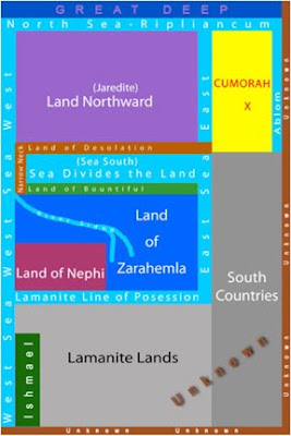
Consequently, when someone creates a map of the Land of Promise, this “internal map” should be compared against the scriptural record to see if the creator followed Mormon’s description of the geography or whether the creator’s own ideas are reflected in the map.
 Actually, most maps created by Book of Mormon scholars and theorists are flawed and can easily be measured against the scriptural record. But the important thing here is to evaluate Nasbaum’s own “internal map” against his criteria of “to show that the modeler understands the text and whether a bias virus has infected it.”
 Let’s take a look at Nasbaum’s internal map (shown above):
1. There is nothing in the scriptural record to say that the “Great Deep” bordered the northern part of the Jaredite Lands or Land Northward. The term “great deep” is used only three times in the Ether account (2:25; 7:27; 8:9), the first has to do with not being able to cross without the Lord’s help, and the other two have to do with a recollection that their fathers were brought across it.
2. We do not know how large Ripliancum was. It may have been the Sea North mentioned in Helaman 3:8, but we do not know this, nor that it covered the entire northern area of the Land Northward as shown.
3. Cumorah and Ablom were not beyond or east of the Sea East as shown. Ether tell us: ”and passed by the hill of Shim, and came over by the place where the Nephites were destroyed, and from thence eastward, and came to a place which was called Ablom, by the seashore” (Ether 9:3). Obviously, the Land of Cumorah and the Land of Ablom were both to the west of that seashore, with Ablom east of Cumorah.
4. We do not know that the Sea South is the Sea that divides the land as shown. “And they built a great city by the narrow neck of land, by the place where the sea divides the land” (Ether 10:20). We do not know if this sea was the South Sea mentioned in Helaman 3:8. This is merely an assumption on Nasbaum’s part. The term “sea that divides the land” is only used once in all the Book of Mormon, and is given no directional reference. It is used only to show that between the Land Northward and the Land Southward, there was a narrow neck and a city was built there where the sea divides the land. This is further described by Mormon “And now, it was only the distance of a day and a half's journey for a Nephite, on the line Bountiful and the land Desolation, from the east to the west sea; and thus the land of Nephi and the land of Zarahemla were nearly surrounded by water, there being a small neck of land between the land northward and the land southward” (Alma 22:32). The point is, there is no reference that the Sea South mentioned in Helaman 3:8 is the same as the “sea that divides the land” mentioned in Ether 10:20.
5. The narrow neck of land has been arbitrarily placed to the left (west) in Nasbaum’s internal map. We do not know if it was toward the middle or to the right (east) of the “sea that divides the land.” On the other hand, since Hagoth built himself several “exceedingly large” ships (Alma 63:5,7-8,10), he would have needed some type of bay or inlet to protect the vessels, which would suggest that the narrow neck of land was not to the far west, but likely toward the middle or east, for the ships were launched into the West Sea (Alma 63:5).
(See the next post, “The H38 Map of the Land of Promise – Part V – The Internal Map Part II,” to see the additional points that contradict Nasbaum’s “internal map”)


No comments:
Post a Comment